Level:
Correct: 0
Incorrect: 0
Marks: 0/0
Practice
Course:
Topics:
Year 7 Maths Smart practice A mixed round aimed at your weak spots
Unit 1
Place value and the number system
Unit 2
Calculating
Unit 3
Factors, multiples and powers
Unit 4
Fractions
Unit 5
Fractions, decimals and percentages
Unit 6
Algebraic expressions
Unit 7
Equations and inequalities
Unit 8
Sequences and graphs
Unit 9
Ratio and proportion
Unit 10
Measures, perimeter, area and volume
Unit 11
Angles and shapes
Unit 12
Probability
Unit 13
Statistics
Avg
score:
–
Topics
done:
0/63

Scale drawings and maps

Practise 23 questions on Scale drawings and maps for Year 7 Maths. Tap or type your answer and find out straight away if you are right, with the Study Helper on hand if you get stuck.

  • 23 questions
  • 1–4 marks each
  • Instant marking
  • No sign-up needed
20 questions, marked as you go

Sample questions with model answers

Here are 4 of the questions in this topic, each with a model answer, an explanation of why it earns the marks and the mark scheme.

Question 1

1 mark

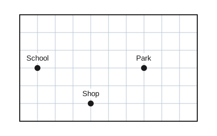
The map is drawn on a grid. Each square of the grid is 1 cm by 1 cm. The scale of the map is 1 cm represents 50 m.

What is the real distance in a straight line from the school to the park?

A map on a grid of squares, 10 squares across and 6 squares down. The school and the park are marked with dots on the same horizontal grid line, the school near the left edge and the park to its right. A shop is marked with a dot lower down. The distance between the places can be found by counting squares.

Model answer

On the map the school and the park are 6 squares apart, so 6 cm.
\(6 \times 50 = 300\) m

Explanation

Count the squares between the school and the park along the grid line: 6 squares, so 6 cm on the map. Each centimetre stands for 50 m, so the real distance is \(6 \times 50 = 300\) m. A common mistake is to count the grid lines instead of the gaps between them.

Mark scheme
  1. 1 mark

    300 m

    Accept 0.3 km. Do not accept 6 cm (the map distance) or 350 m.

Question 2

2 marks

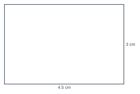
The diagram is a scale drawing of a classroom. The scale is 1 cm represents 2 m.

Work out the real length and the real width of the classroom, in metres.

Geometry diagram, drawn accurately to scale. A rectangle (its vertices are not labelled). The unlabelled side going to the right is labelled 4.5 cm. The unlabelled side going upwards is labelled 3 cm.

Model answer

Length: \(4.5 \times 2 = 9\) m
Width: \(3 \times 2 = 6\) m

Explanation

Each centimetre on the drawing stands for 2 m in the real classroom, so multiply each drawing length by 2. The 4.5 cm side is \(4.5 \times 2 = 9\) m and the 3 cm side is \(3 \times 2 = 6\) m. A common mistake is to add 2 instead of multiplying.

Mark scheme
  1. 1 mark

    One correct real length: 9 (m) or 6 (m); or the correct answer 9 m and 6 m with no working

    Implied by \(4.5 \times 2\) or \(3 \times 2\).

  2. 1 mark

    Length 9 m and width 6 m

    Both needed. The question gives the unit, so 9 and 6 are fine. Do not accept 6.5 and 5 (adding 2). A correct answer with no working scores full marks.

Question 3

3 marks

A map has the scale 2 cm represents 5 km.

Two towns are 9 cm apart on the map. Work out the real distance between the towns.

A road is 30 km long. How long is the road on the map?

Model answer

2 cm represents 5 km, so 1 cm represents \(5 \div 2 = 2.5\) km.
Towns: \(9 \times 2.5 = 22.5\) km
Road: 10 km is 4 cm, so 30 km is \(3 \times 4 = 12\) cm

Explanation

This scale does not start with 1 cm, so first find what 1 cm stands for: \(5 \div 2 = 2.5\) km. The towns are \(9 \times 2.5 = 22.5\) km apart. For the road, 10 km is 4 cm on the map, and 30 km is 3 times as far, so it is 12 cm. A common mistake is to treat the scale as if 1 cm represented 5 km.

Mark scheme
  1. 1 mark

    1 cm represents 2.5 km; or the correct answers 22.5 km and 12 cm with no working

    Or another correct way of using the scale, e.g. 4 cm represents 10 km.

  2. 1 mark

    22.5 km

    Do not accept 45 km (from \(9 \times 5\)) or 3.6 km.

  3. 1 mark

    12 cm

    Do not accept 6 cm (from \(30 \div 5\)) or 15 cm. A correct answer with no working scores full marks.

Question 4

4 marks

A logo is 8 cm wide and 5 cm tall. Nina enlarges the logo so that it is 20 cm wide.

She wants to print the enlarged logo on a card that is 30 cm wide and 12 cm tall.

What is the scale factor of the enlargement? How tall is the enlarged logo? Will it fit on the card?

Model answer

Scale factor = \(20 \div 8 = 2.5\)
Enlarged height = \(5 \times 2.5 = 12.5\) cm
Width: 20 cm is less than 30 cm, so the width fits.
Height: 12.5 cm is more than 12 cm, so it does not fit.
No, the logo will not fit on the card.

Explanation

First find the scale factor of the enlargement: \(20 \div 8 = 2.5\). The height must be multiplied by the same scale factor, so it becomes \(5 \times 2.5 = 12.5\) cm. The card is wide enough, but it is only 12 cm tall, so the logo is half a centimetre too tall. A common mistake is to add 12 cm to the height because 12 cm was added to the width.

Mark scheme
  1. 1 mark

    Scale factor \(20 \div 8 = 2.5\)

    Or 4 cm becomes 10 cm, or 1 cm becomes 2.5 cm.

  2. 1 mark

    Enlarged height \(5 \times 2.5 = 12.5\) cm

    Follow through from their scale factor.

  3. 1 mark

    Compares with the card: the width, 20 cm, fits in 30 cm, but the height, 12.5 cm, is more than 12 cm

    The height comparison is the one that matters.

  4. 1 mark

    No, it will not fit, because the enlarged logo is 12.5 cm tall and the card is only 12 cm tall

    Needs the correct height. "No" alone scores 0. Do not accept answers that add 12 cm to the height (17 cm). Any complete correct method with this conclusion scores all 4 marks.

Ready to try the rest? Tap or type your answers and see straight away how you did.

Topic notes

Scale drawings and maps

The big idea

A scale drawing shows a real object with every length divided (or multiplied) by the same number, so the shape stays the same. Maps and plans of rooms are scale drawings. The scale tells you how lengths on the drawing match real lengths, for example "1 cm represents 5 m".

Using a scale

  • From the drawing to real life: multiply by the scale.
  • From real life to the drawing: divide by the scale.

Real lengths are usually much bigger than the drawing, so check that your answer makes sense.

A plan of a swimming pool uses the scale 1 cm represents 5 m. Find the real length and width of the pool.

Geometry diagram, drawn accurately to scale. A rectangle (the pool) (its vertices are not labelled) (shaded). The unlabelled side going to the right is labelled 5 cm. The unlabelled side going upwards is labelled 2.5 cm. The text "Pool" is written inside the shape.
The plan of the pool. Scale: 1 cm represents 5 m.

Length: 5 cm on the plan, so \(5 \times 5 = 25\) m.

Width: 2.5 cm on the plan, so \(2.5 \times 5 = 12.5\) m.

A map uses the scale 1 cm represents 3 km. A canal is 21 km long and a lake is 4.5 km across. How long should each be on the map?

Real life to the map, so divide by 3.

Canal: \(21 \div 3 = 7\) cm. Lake: \(4.5 \div 3 = 1.5\) cm.

If the scale uses two different units, such as 1 cm represents 50 cm, change the real length into the same unit first. A wardrobe 1.8 m wide is 180 cm, so on the plan it is \(180 \div 50 = 3.6\) cm wide.

Scale factors

When a drawing is enlarged, every length is multiplied by the same number, called the scale factor. The shape stays the same, and so do the angles. Never add the same amount to every length: that changes the shape.

A drawing of a door is 2 cm wide and 5 cm tall. It is enlarged so that it is 3 cm wide. Ben says the new height is 6 cm, because 1 cm was added to the width. Find the correct height.

Scale factor: \(3 \div 2 = 1.5\)

Height: \(5 \times 1.5 = 7.5\) cm.

Ben's door, 3 cm by 6 cm, would look too wide for its height.

Geometry diagram, drawn accurately to scale. A rectangle (the drawing) (its vertices are not labelled) (shaded). A rectangle (the enlargement) (its vertices are not labelled) (shaded). The unlabelled side going to the right is labelled 2 cm. The unlabelled side going downwards is labelled 5 cm. The unlabelled side going to the right is labelled 3 cm. The unlabelled side going upwards is labelled 7.5 cm.
The door and its enlargement with scale factor 1.5. Both lengths are multiplied by 1.5.

Stretch: scales written as a ratio

A map scale such as \(1 : 10{,}000\) means 1 cm on the map is 10,000 cm in real life (any unit works, as long as both sides use the same one). Change the answer into metres (divide by 100) or kilometres (divide by 100,000) so it makes sense. On this map, a lake 3.5 cm across is \(3.5 \times 10{,}000 = 35{,}000\) cm, which is 350 m.

Remember

  • Drawing to real life: multiply. Real life to drawing: divide.
  • Change lengths into the units of the scale before you start.
  • In an enlargement, every length is multiplied by the scale factor.

Common mistakes

  • Multiplying when you should divide: a real distance changed into a map distance must get smaller.
  • Forgetting to change units: with 1 cm represents 50 cm, change 1.8 m into 180 cm before you divide.
  • Measuring straight across when a route goes through another place: measure each part and add.
  • Adding the same amount to every length in an enlargement instead of multiplying.
  • Giving the answer to a ratio scale in the wrong unit: 35,000 cm is 350 m, not 35,000 m.

Top tip

Say the scale as a sentence before you start ("1 cm on the map is 3 km in real life"), then ask yourself: should my answer be bigger or smaller than the number I started with?

Study Helper Hints first, answers after you try

Stuck on this one? Ask for a hint and I’ll point you in the right direction, without giving the answer away. Once you’ve checked your answer, I’ll show you how the marks are awarded.