UK rock types and how geology shaped the landscape
Practise 26 exam-style questions on UK rock types and how geology shaped the landscape for Edexcel GCSE Geography B (Paper 2). Write your answer as you would in the exam and get it marked in seconds against the mark scheme, point by point, with the Study Helper on hand if you get stuck.
26 questions
1–8 marks each
Instant marking
No sign-up needed
20 questions, marked as you go
Sample questions with model answers
Here are 4 of the questions in this topic, each with a model answer, an explanation of why it earns the marks and the mark scheme an examiner would use.
Question 1
1 mark
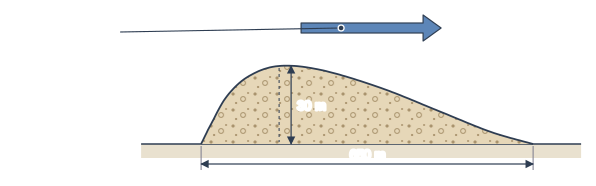
Figure 1 shows the side view of a landform found in some lowland areas of northern England and Scotland. It is made of till (boulder clay).
Identify the landform shown in Figure 1.
Model answer
A drumlin.
Explanation
A drumlin is a smooth, egg-shaped hill of till deposited and shaped by moving ice: its steep, blunt end faces the direction the ice came from and its long, tapering end points the way the ice moved. A common error is to call it a moraine, which is a ridge of material dropped at the edge or snout of a glacier.
Mark scheme
1 mark
Drumlin
Accept drumlin (including minor misspellings such as drumlen). Do not accept moraine, terminal moraine, esker, erratic or roche moutonnee. All other answers are incorrect.
Question 2
2 marks
State two characteristics of slate.
Model answer
Slate is a metamorphic rock formed from mudstone. It splits into thin, flat sheets.
Explanation
Any two features of the rock itself score: how it formed, how it splits, its grain size, hardness, permeability or colour. Naming where slate is found or what it is used for does not describe a characteristic.
Mark scheme
1 mark
Any one valid characteristic, e.g. it is a metamorphic rock / formed from mudstone or shale changed by heat and pressure / splits into thin, flat sheets / fine-grained / hard and resistant to erosion / impermeable / dark grey or blue-grey
Award 1 mark for each characteristic, up to 2 marks. Accept 'splits easily into thin layers, so it is used for roofing'. Do not credit uses alone (e.g. 'used for roofs'), places alone (e.g. 'found in Snowdonia') or 'it is a rock'.
1 mark
A second, different valid characteristic from the list above
The two characteristics must be different; do not credit 'hard' and 'resistant to erosion' as two separate characteristics.
Question 3
3 marks
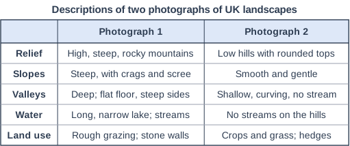
Figure 1 describes two photographs of UK landscapes. The descriptions were written for this course.
Compare the landscapes shown in Photograph 1 and Photograph 2.
Model answer
The landscape in Photograph 1 is much higher and more rugged than in Photograph 2, with steep, rocky slopes and scree instead of smooth, gentle slopes. Photograph 1 has a deep, flat-floored valley containing a long lake and streams, whereas the valley in Photograph 2 is shallow and has no stream. Both are used for grazing sheep, but Photograph 2 also has fields of crops, so it is farmed more intensively.
Explanation
Each mark needs a comparison that refers to both photographs, such as relief, slopes, rock, water or land use. Explaining why the landscapes differ (rock type, glaciation) earns nothing on a 'Compare' question.
Mark scheme
3 marks
Award 1 mark for each valid comparative point, up to 3 marks, e.g. Photograph 1 is higher and more rugged than Photograph 2 / Photograph 1 has steep, rocky slopes whereas Photograph 2 has smooth, gentle slopes / bare rock and scree show in Photograph 1 but no rock shows in Photograph 2 / Photograph 1 has a deep, flat-floored valley whereas the valley in Photograph 2 is shallow / Photograph 1 has a lake and streams whereas there are no streams on the hills in Photograph 2 / both are used for grazing sheep (similarity) / Photograph 2 has crops but Photograph 1 only rough grazing / stone walls in Photograph 1 but hedges in Photograph 2
Award marks for comparative statements (whereas, but, more, less, both), not for separate descriptions of each photograph. Do not credit data lifts directly from the figure, e.g. copying one row without comparing. Do not credit explanation, e.g. 'because Photograph 1 is made of granite' or 'because it was glaciated'. Similarities are credited as well as differences.
Question 4
4 marks
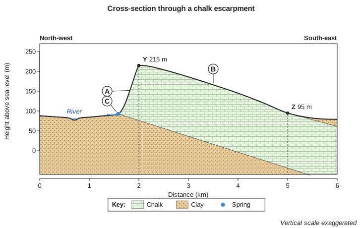
Figure 1 is a cross-section through a chalk escarpment.
Using Figure 1, explain why the slope labelled A is much steeper than the slope labelled B.
Model answer
The chalk layer in Figure 1 is tilted, dipping gently towards the south-east. Slope B follows the top of this tilted layer, so it is a long, gentle dip slope. Slope A cuts across the edge of the chalk layer, where it rests on clay. The clay is softer than the chalk, so it is eroded more quickly at the foot of the slope, and springs at the junction wash material away, undercutting the chalk above. This keeps slope A steep as the escarpment slowly retreats north-westwards.
Explanation
Good answers link each slope to the geology shown: the gentle slope follows the dip of the chalk, and the steep slope is the exposed edge of the chalk kept steep by erosion of the weaker clay below. Describing the steepness of the slopes without explaining it earns no marks.
Mark scheme
1 mark
A basic reason, e.g. the chalk layers are tilted (dip) gently to the south-east, so slope B follows the top of the chalk layer / at A the edge of the tilted chalk is exposed / the clay beneath the chalk at A is softer and eroded more quickly
Mark as (1+1)+(1+1) or 1+(1+1+1). Examples: The chalk layer dips gently to the south-east (1), so the gentle slope B follows the slope of the rock layer (the dip slope) (1). At A the land cuts across the edge of the tilted chalk (1), and the soft clay at the foot of the slope is eroded faster than the chalk above, undercutting it so the scarp stays steep (1). Springs at the junction of the chalk and clay (1) wash away material at the foot of slope A, keeping it steep (1). Chalk is more resistant than the clay (1) so it stands up as a steep edge above the clay vale (1). Accept any other appropriate response.
1 mark
Development of the reason
Accept any appropriate development of the first reason.
1 mark
A second reason, or further development of the first
Evidence from Figure 1 (e.g. the chalk-clay boundary sloping down to the south-east; Y at 215 m; the clay vale at about 90 m) may be used to support either reason. Readings from Figure 1 within half an axis interval (plus or minus 25 m) of the heights given are acceptable.
1 mark
Development of the second reason, or further development
Do not credit description of the two slopes without explanation, e.g. 'A rises 125 m in 0.5 km'.
Ready to try the rest? Every answer you write is marked against the mark scheme, so you can see exactly where the marks are.
Ctrl + Enter to check
Study HelperHints first, answers after you try
Stuck on this one? Ask for a hint and I’ll point you in the right direction, without giving the answer away. Once you’ve checked your answer, I’ll show you how the marks are awarded.