
Level:
Correct: 0
Incorrect: 0
Marks: 0/0
Exam Practice
Course:
Topics:
Edexcel GCSE Geography B (Paper 2) Smart practice A mixed round aimed at your weak spots
Unit 4
Topic 4: The UK's evolving physical landscape
Unit 5
Topic 5: The UK's evolving human landscape
Unit 6
Topic 6: Geographical investigations
Avg
score:
–
Topics
done:
0/28

Storm hydrographs and physical factors in river basins

Practise 26 exam-style questions on Storm hydrographs and physical factors in river basins for Edexcel GCSE Geography B (Paper 2). Write your answer as you would in the exam and get it marked in seconds against the mark scheme, point by point, with the Study Helper on hand if you get stuck.

  • 26 questions
  • 1–8 marks each
  • Instant marking
  • No sign-up needed
20 questions, marked as you go

Sample questions with model answers

Here are 4 of the questions in this topic, each with a model answer, an explanation of why it earns the marks and the mark scheme an examiner would use.

Question 1

1 mark

Identify which one of the following drainage basins is most likely to have the shortest lag time after heavy rain.

Choose your answer.

  • A An elongated basin on permeable chalk with gentle slopes
  • B A circular basin on permeable sandstone with gentle slopes
  • C An elongated basin on impermeable slate with steep slopes
  • D A circular basin on impermeable granite with steep slopes

Model answer

D

Explanation

Impermeable rock stops water percolating into the ground, steep slopes speed up surface runoff, and in a circular basin water from all parts reaches the river at about the same time, so D gives the shortest lag. C is the closest distractor: it differs only in shape.

Mark scheme
  1. 1 mark

    D (A circular basin on impermeable granite with steep slopes)

    Accept the letter or the option written out; do not credit more than one answer. A is incorrect: permeable rock, gentle slopes and an elongated shape all slow water down, giving a long lag time. B is incorrect: the circular shape helps, but permeable rock and gentle slopes let water soak in and move slowly. C is incorrect: impermeable rock and steep slopes give rapid runoff, but in an elongated basin water from the far end arrives later than in a circular basin.
Question 2

2 marks

Explain one reason why a drainage basin with clay soils usually responds more quickly to heavy rainfall than a drainage basin with sandy soils.

Model answer

Clay soils have very small pore spaces, so rain cannot infiltrate quickly. More of it runs over the surface into the river, so discharge rises sooner and the lag time is shorter.

Explanation

The first mark is for a property of clay or sandy soil that controls infiltration, the second for linking it to faster surface runoff and a shorter lag. Answers that confuse soil with rock type, or give no reason, do not reach 2 marks.

Mark scheme
  1. 1 mark

    Identifies a valid reason, e.g. clay soils have small pore spaces / a low infiltration rate / become saturated (waterlogged) quickly, whereas sandy soils have large pores that let water infiltrate

    Examples: Clay soils have tiny pore spaces so water infiltrates very slowly (1) and the rain runs off the surface into the river quickly (1). Sandy soils have large pores so rain soaks in easily (1) and moves slowly through the soil as throughflow, delaying the peak (1). Clay soils soon become waterlogged (1) so further rain becomes surface runoff (1). Accept any other appropriate response.

  2. 1 mark

    Develops the reason, e.g. so more rain becomes surface runoff and reaches the river quickly, giving a shorter lag time / steeper rising limb

    The development must explain the faster response (more or quicker surface runoff, shorter lag time, higher peak). Do not credit 'clay is impermeable' alone for both marks.

Question 3

3 marks

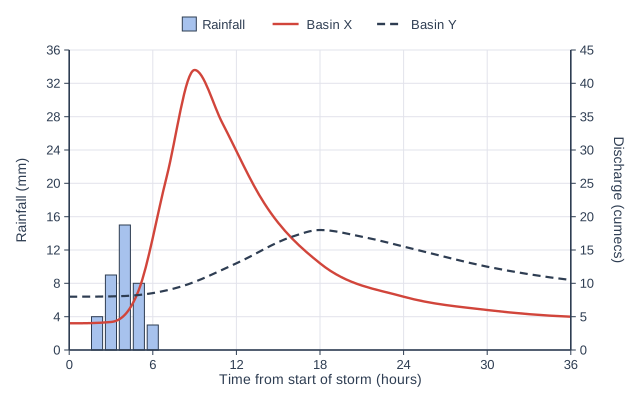
Study Figure 1, which shows storm hydrographs for two drainage basins of similar size, X and Y, after the same storm (data written for this course).

Compare the hydrograph for Basin X with the hydrograph for Basin Y.

Storm hydrograph. Rainfall is drawn as blue bars rising from the time axis, read on the left axis (Rainfall in mm, 0 to 36, numbered every 4); river discharge is drawn as two curves, read on the right axis ("Discharge (cumecs)", 0 to 45, numbered every 5). Time is "Time from start of storm (hours)" along the bottom, 0 to 36, numbered every 6. A key shows Rainfall (bars), Basin X (solid red line) and Basin Y (dashed line). Rainfall bars (centred on their times): 2 h 4 mm, 3 h 9 mm, 4 h 15 mm, 5 h 8 mm, 6 h 3 mm. "Basin X" (solid) discharge (a smooth curve through these points): 0 h 4, 3 h 4.2, 5 h 9, 7 h 26, 9 h 42, 11 h 34, 14 h 22, 18 h 13, 24 h 8, 30 h 6, 36 h 5 cumecs. "Basin Y" (dashed) discharge (a smooth curve through these points): 0 h 8, 4 h 8.1, 8 h 9.5, 12 h 13, 16 h 17, 18 h 18, 21 h 17, 25 h 15, 30 h 12.5, 36 h 10.5 cumecs.

Model answer

Basin X has a much higher peak discharge than Basin Y, about 42 cumecs compared with about 18 cumecs. Basin X also has a shorter lag time, about 5 hours compared with 14 hours for Basin Y, and its rising and falling limbs are much steeper. Basin Y has a higher base flow than Basin X (about 8 cumecs against 4 cumecs).

Explanation

Each mark needs a statement that refers to both basins, such as 'higher than' or 'shorter than'; data makes the comparison precise. Reasons for the differences are not credited because the command word is Compare.

Mark scheme
  1. 1 mark

    A valid comparative point, e.g. Basin X has a much higher peak discharge than Basin Y (about 42 cumecs against about 18 cumecs, more than twice as high)

    Award 1 mark for each different comparative point, up to 3. Valid comparisons: higher peak discharge in X (about 42 against about 18 cumecs); shorter lag time in X (about 5 hours against about 14 hours) / X peaks about 9 hours earlier (treat these as one point); steeper rising limb in X; steeper falling limb in X / X falls back towards its base flow sooner; Y has the higher base flow (about 8 against about 4 cumecs); Y's discharge stays higher than X's at the end of the period (after about 16 hours). Readings within half a gridline (plus or minus 2.5 cumecs on the discharge scale and 3 hours on the time scale) of the values given are acceptable, and so are lag times worked from such readings. Do not credit explanation (e.g. reasons such as rock type). Do not credit statements about one basin only, or data lifted for each basin without a comparison.

  2. 1 mark

    A second, different comparative point, e.g. Basin X has a shorter lag time (about 5 hours against about 14 hours)

    Must be a different comparison from the one already credited, using the list above.

  3. 1 mark

    A third, different comparative point, e.g. Basin X has steeper rising and falling limbs / Basin Y has a higher base flow (about 8 against 4 cumecs)

    Must be different from both of the other comparisons credited.

Question 4

4 marks

Explain how a period of very heavy rainfall can increase the sediment load of an upland river.

Model answer

Very heavy rain raises the river's discharge and velocity, so the river has much more energy. It erodes its bed and banks more quickly by hydraulic action and abrasion, and it can pick up and carry larger stones as well as fine particles. The rain also saturates the soil on the steep valley sides, making it heavier and weaker, so slopes can slump or slide and drop large amounts of soil and rock straight into the channel, adding further to the load.

Explanation

The first mark is for an effect of the rain (more energy in the river, or saturated slopes, or soil washed off by runoff). Further marks come from linking each step to more sediment entering or being carried by the river. Saying only that the river gets bigger or floods does not explain the extra load.

Mark scheme
  1. 1 mark

    Identifies a relevant effect of the rain, e.g. it raises the river's discharge and velocity / it saturates the valley sides / rainsplash and surface runoff wash soil off the slopes

    Award one mark for identifying an effect of the heavy rain and up to three further marks for linked development. Example chains: Heavy rain raises the river's discharge and velocity (1), giving it more energy (1), so it erodes its bed and banks by hydraulic action and abrasion (1) and can pick up and carry larger particles, so the load increases (1). The rain saturates the soil on steep valley sides (1), making it heavier and weaker (1), so the slopes slump or slide (1), dropping large amounts of soil and rock straight into the channel (1). Raindrops dislodge soil particles on bare slopes (1) and surface runoff carries them downhill (1) into streams, where they are carried in suspension (1). Accept any other appropriate response.

  2. 3 marks

    Up to three further marks for linked development, explaining how more sediment enters or is carried by the river

    Each development mark must add a new linked step. Answers may combine routes (e.g. more energy and more supply from slopes) if each step is linked. Do not credit 'the river floods' or 'there is more water' without linking to erosion, transport or sediment supply.

Ready to try the rest? Every answer you write is marked against the mark scheme, so you can see exactly where the marks are.

Study Helper Hints first, answers after you try

Stuck on this one? Ask for a hint and I’ll point you in the right direction, without giving the answer away. Once you’ve checked your answer, I’ll show you how the marks are awarded.