
Level:
Correct: 0
Incorrect: 0
Marks: 0/0
Exam Practice
Course:
Topics:
Edexcel GCSE Geography B (Paper 2) Smart practice A mixed round aimed at your weak spots
Unit 4
Topic 4: The UK's evolving physical landscape
Unit 5
Topic 5: The UK's evolving human landscape
Unit 6
Topic 6: Geographical investigations
Avg
score:
–
Topics
done:
0/28

River flood risk and flood management

Practise 27 exam-style questions on River flood risk and flood management for Edexcel GCSE Geography B (Paper 2). Write your answer as you would in the exam and get it marked in seconds against the mark scheme, point by point, with the Study Helper on hand if you get stuck.

  • 27 questions
  • 1–8 marks each
  • Instant marking
  • No sign-up needed
20 questions, marked as you go

Sample questions with model answers

Here are 4 of the questions in this topic, each with a model answer, an explanation of why it earns the marks and the mark scheme an examiner would use.

Question 1

1 mark

Study Figure 1, which shows part of an OS map of an imaginary area around the town of Pelling (written for this course). Point A is on farmland upstream of Pelling, where a flood storage area has been proposed. Point B is on farmland downstream of the town.

Using the scale, state the straight-line distance from A to B in kilometres.
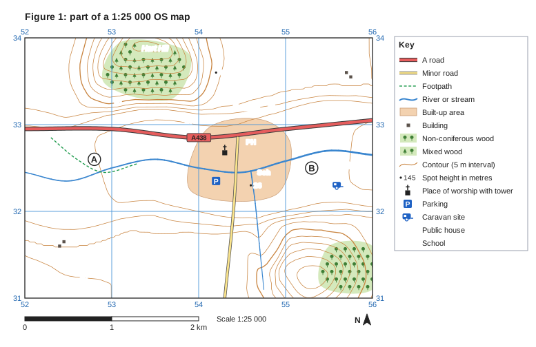
Figure 1: part of a 1:25 000 OS map. Ordnance Survey map extract at a scale of 1:25 000. Blue grid lines divide it into 4 by 3 squares, each 1 km across; the eastings 52, 53, 54, 55, 56 are printed along the top and bottom (increasing to the east) and the northings 31, 32, 33, 34 up both sides (increasing to the north). Brown contour lines show the height of the land every 5 m, with every 50 m line drawn thicker; heights printed on contour lines: 25 m, 30 m, 35 m, 40 m, 50 m. Spot heights (a dot with the height in metres): 26 in the centre of the map; 47 in the north of the map. Water (blue): a river runs between the west edge and the east edge; a stream runs between the south-east of the map and the centre of the map. Roads and paths: the A438 (A road) runs between the west edge and the east edge; a minor road runs between the centre of the map and the south edge; a footpath (green dashed lines). Land use: a built-up area (shaded orange) in the centre of the map; 4 separate buildings (small black squares); mixed woodland (green with tree symbols) in the north of the map; non-coniferous woodland (green with tree symbols) in the south-east of the map. Symbols: place of worship with tower in the centre of the map; "Sch" (school) in the east of the map; caravan site in the east of the map; parking in the centre of the map; "PH" (public house) in the centre of the map. Names printed: "Pelling" in the north of the map; "Hart Hill" in the north of the map; "R. Sallow" in the west of the map; "Low Fm" in the south-west of the map; "Hart Fm" in the north-east of the map. Letters in circles mark places: A in the west of the map; B in the east of the map. A key beside the map explains: A road, minor road, footpath, river or stream, built-up area, building, non-coniferous wood, mixed wood, contour (5 m interval), spot height in metres, place of worship with tower, parking, caravan site, PH = public house, Sch = school. Below the map: a scale bar marked 0, 1 and 2 km (1 km is the width of one grid square) and a north arrow pointing to the top of the map.

Model answer

2.5 km

Explanation

On a 1:25 000 map each grid square is 1 km across, so A to B is about two and a half squares, or 2.5 km; the scale bar gives the same result. A common error is to measure along the winding river instead of in a straight line.

Mark scheme
  1. 1 mark

    2.5 km

    Accept 2.4 to 2.6 km. Accept 2,400 to 2,600 m if the unit is given as metres. Do not credit a distance measured along the river or the road, or an answer in grid squares without units.
Question 2

2 marks

Explain one disadvantage of flood plain retention as a way of managing flood risk.

Model answer

Fields beside the river are deliberately allowed to flood, so farmers can lose their crops or grazing land for weeks. They lose income and may need to be paid compensation.

Explanation

A disadvantage needs a reason why it is a problem, such as lost income or limited protection. Saying it is expensive is usually wrong, because this method is normally cheaper than walls or embankments.

Mark scheme
  1. 1 mark

    Identifies a valid disadvantage, e.g. farmland is flooded / it needs a large area of land / it may not hold enough water in an extreme flood / compensation must be paid / land cannot be built on

    Examples: Fields beside the river are flooded on purpose (1) so farmers lose crops or grazing and income, and may need compensation (1). It needs a large area of flood plain (1) which may not be available where towns have already built on it (1). The storage space can fill up in a very large flood (1) so towns downstream may still flood (1). Accept any other appropriate response.

  2. 1 mark

    Develops the disadvantage

    The development must explain why it is a problem. Do not credit 'it is expensive' without explanation (flood plain retention is usually cheaper than hard engineering).

Question 3

2 marks

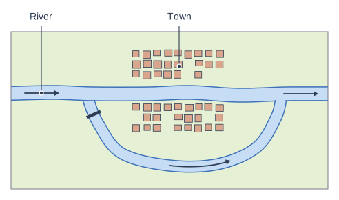
Study Figure 1, which shows a flood relief channel built to protect a town.

Explain one disadvantage of this method of managing flood risk.

Diagram of a flood relief channel (plan view). A plan view of a flood relief channel. A river flows from left to right through a town (small buildings on both banks). Upstream of the town a second channel, the flood relief channel, leaves the river through a sluice gate (thick bar across its entrance), curves round below the town and rejoins the river downstream. When the river is high, the sluice gate is opened and excess water is diverted along the relief channel (arrow), away from the town. The label "Town" points to the built-up area of small buildings on both banks of the main river; the label "River" points to the main river flowing from left to right through the built-up area.

Model answer

The water diverted around the town rejoins the river downstream. This can make the flood peak higher for places below the outlet, so they may flood more often even though the town is protected.

Explanation

A disadvantage needs a reason why it matters, such as cost or moving the problem downstream. Describing how the channel works is not a disadvantage.

Mark scheme
  1. 1 mark

    Identifies a valid disadvantage, e.g. it is expensive to build (land, digging, sluice gates) / water rejoins the river downstream, which may raise flood risk there / it takes up a large area of land / the sluice gates must be maintained and operated

    Examples: Digging a new channel and buying the land is very expensive (1), so the scheme is only affordable where many properties are protected (1). The diverted water rejoins the river below the town (1) so places downstream may get a higher flood peak (1). The channel takes up a large area of land (1) which could otherwise be farmed or built on (1). Credit local detail, e.g. some villages downstream of the Jubilee River relief channel blamed it for flooding in 2003 and 2014, although the Environment Agency says it does not raise their risk (1). Accept any other appropriate response.

  2. 1 mark

    Develops the disadvantage

    The development must explain why the disadvantage is a problem or who it affects.

Question 4

4 marks

Explain two reasons why soft engineering is often chosen to manage flood risk in rural areas.

Model answer

Firstly, rural areas have few homes at risk, so building expensive flood walls or embankments would cost more than the damage they would prevent. Soft engineering is much cheaper, so it gives better value for money.

Secondly, rural rivers have open farmland beside them, which can be allowed to flood and store water. This protects towns downstream and can create wetland habitats for wildlife.

Explanation

Each reason needs a feature of rural areas or of soft engineering (1) and an explanation of why it suits rural places (1). A reason that is true of everywhere, such as 'it is natural', needs explaining to gain the second mark.

Mark scheme
  1. 1 mark

    Identifies a first reason, e.g. it is cheaper / few properties are at risk so hard engineering would not be good value / there is space on the flood plain / it creates wildlife habitats / it works with natural processes and lasts longer / it reduces risk for towns downstream

    Examples: Rural areas have few properties at risk (1), so expensive walls and embankments would cost more than the damage they prevent and would fail a cost-benefit test (1). There is open farmland beside rural rivers (1), so it can be used to store floodwater without damaging buildings (1). Soft engineering such as river restoration creates wetlands (1), which increases wildlife and can attract visitors (1). Storing water in rural areas upstream (1) lowers the flood peak for towns downstream (1). Accept any other appropriate response.

  2. 1 mark

    Develops the first reason

    The development must explain why the reason makes soft engineering suitable in rural areas.

  3. 1 mark

    Identifies a second, different reason

    The two reasons must be different (e.g. cost and environmental benefits).

  4. 1 mark

    Develops the second reason

    As for the first reason.

Ready to try the rest? Every answer you write is marked against the mark scheme, so you can see exactly where the marks are.

Study Helper Hints first, answers after you try

Stuck on this one? Ask for a hint and I’ll point you in the right direction, without giving the answer away. Once you’ve checked your answer, I’ll show you how the marks are awarded.