Practise 26 exam-style questions on Coastal fieldwork: enquiry questions and methods for Edexcel GCSE Geography B (Paper 2). Write your answer as you would in the exam and get it marked in seconds against the mark scheme, point by point, with the Study Helper on hand if you get stuck.
26 questions
1–8 marks each
Instant marking
No sign-up needed
20 questions, marked as you go
Sample questions with model answers
Here are 4 of the questions in this topic, each with a model answer, an explanation of why it earns the marks and the mark scheme an examiner would use.
Question 1
1 mark
Before choosing sites, a group of students read the Shoreline Management Plan for their area. It gives one stretch of coast the policy 'no active intervention'.
Identify what the students should expect to find on this stretch of coast.
Choose your answer.
A New defences being built to protect the coast
B No new defences, so the coast is left to erode naturally
C The line of defences moved inland to create salt marsh
D Defences built further out to sea to gain new land
Model answer
B
Explanation
Shoreline Management Plans give each stretch of coast one of four policies: hold the line, advance the line, managed realignment or no active intervention. 'No active intervention' means no money is spent on defences, so natural processes continue. Knowing the policy helps students choose managed and unmanaged sites to compare.
Mark scheme
1 mark
B (No new defences, so the coast is left to erode naturally)
Accept the letter or the option written out; do not credit more than one answer. A is incorrect: building or maintaining defences is 'hold the line'. C is incorrect: moving the line of defence inland is managed realignment. D is incorrect: building defences seawards is 'advance the line'.
Question 2
2 marks
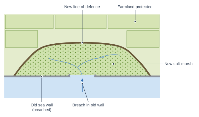
Figure 1 shows a managed realignment scheme on a stretch of coast.
Suggest one qualitative method that students could use to judge how successful the scheme has been, and explain why it would be useful.
Model answer
They could interview farmers who own land behind the new embankment. They could say whether their fields have flooded since the old sea wall was breached, which would show whether the new line of defence is protecting the farmland as intended.
Explanation
One mark is for a qualitative method, such as interviews or annotated sketches, and one for explaining what it would show about the success of the scheme. Good answers link the method to the scheme's aims, such as protecting farmland or creating salt marsh. Measurements and counts are quantitative, so they do not answer the question.
Mark scheme
1 mark
Suggests a suitable qualitative method, e.g. interviews or questionnaires with open questions / annotated field sketches / annotated photographs / a written description of the salt marsh
Examples: Interview farmers and residents behind the new embankment (1) to find out whether their land and homes have flooded since the scheme was built (1). Draw annotated field sketches of the new salt marsh (1) to record how much vegetation and wildlife has developed, showing whether it is becoming a natural defence (1). Take photographs from the same viewpoints as photographs taken before the scheme (1) to show how the coast has changed (1). Interview visitors or bird-watchers using the area (1) to find out whether the scheme has improved the area for recreation and wildlife (1). Accept any other appropriate response. Do not credit quantitative methods (e.g. measuring the height of the marsh, counting birds) or secondary data.
1 mark
Explains why the method would help judge the success of the scheme
The development must explain what the method would show about whether the scheme has met its aims, e.g. protecting farmland or homes, or creating salt marsh as a natural defence.
Question 3
2 marks
You have carried out your own fieldwork investigating the impact of coastal management on coastal processes and communities.
Explain one way in which the coastal management at your fieldwork location influenced where you chose to collect your data.
Model answer
We placed one site on each side of three of the groynes. This let us measure the height of the beach on the updrift and downdrift side of each groyne, so we could see whether the groynes were trapping sediment moved by longshore drift.
Explanation
The first mark is for how the management affected where data were collected, such as sites either side of groynes or beyond the end of a sea wall. The second is for what that choice allowed the student to find out. General reasons for choosing a location, such as being close to school, do not answer this question.
Mark scheme
1 mark
Identifies a way the management affected the choice of sites
Answers will vary with the centre's fieldwork; credit any valid enquiry, location and method. Do not penalise the absence of a named fieldwork location. Examples: We put sites on both sides of each groyne (1) so we could measure whether sediment built up on the updrift side, showing the groyne was trapping longshore drift (1). We measured profiles in front of the sea wall and on the beach beyond the end of the wall (1) to compare a managed and an unmanaged beach (1). We chose a site just downdrift of the last groyne (1) because the beach there might be starved of sediment, which would show a negative effect of the management (1). We interviewed people in the houses closest to the new rock armour (1) because they were the community most affected by the scheme (1). Accept any other appropriate response.
1 mark
Develops the point, explaining why sites were placed there
The development must explain what the choice allowed the student to find out about the management.
Question 4
4 marks
You have carried out your own fieldwork investigating the impact of coastal management on coastal processes and communities.
Explain two ways in which you planned your data collection so that your results would show the effect of the coastal management rather than the effect of other factors.
Model answer
1. We measured beach profiles on the part of the beach with groynes and on the part beyond the last groyne, less than 1 km away. Because both parts face the same direction and get the same waves, a difference between them was more likely to be caused by the groynes. 2. We checked a geology map and chose sites where the cliffs were all glacial till. This meant that differences in the beach or sediment were not caused by the cliffs being made of different rock.
Explanation
Each way earns 1 mark for how the student controlled other factors and 1 for explaining why that mattered. A fair investigation compares managed and unmanaged sites that are alike in other ways, such as geology, aspect and timing. Describing methods without saying how they isolated the effect of the management does not earn the development marks.
Mark scheme
1 mark
First way: identifies a valid way of isolating the effect of the management
Answers will vary with the centre's fieldwork; credit any valid enquiry, location and method. Do not penalise the absence of a named fieldwork location. Examples: We compared a managed stretch with an unmanaged stretch nearby (1) so we could see what the beach would be like without the defences (1). We chose sites with the same geology and facing the same direction, using a geology map (1) so differences were not caused by rock type or wave exposure (1). We measured on both sides of the same groynes on the same day (1) so the tide and weather were the same for both sides (1). We collected all the data at the same state of the tide (1) so the width of the beach was not affected by the water level (1). Accept any other appropriate response.
1 mark
Develops the first way
The development must explain how this stopped another factor affecting the results.
1 mark
Second way: identifies a different valid way
The two ways must be different.
1 mark
Develops the second way
As for the first way.
Ready to try the rest? Every answer you write is marked against the mark scheme, so you can see exactly where the marks are.
Ctrl + Enter to check
Study HelperHints first, answers after you try
Stuck on this one? Ask for a hint and I’ll point you in the right direction, without giving the answer away. Once you’ve checked your answer, I’ll show you how the marks are awarded.