A major UK city: decline, decentralisation and growth
Practise 26 exam-style questions on A major UK city: decline, decentralisation and growth for Edexcel GCSE Geography B (Paper 2). Write your answer as you would in the exam and get it marked in seconds against the mark scheme, point by point, with the Study Helper on hand if you get stuck.
26 questions
1–12 marks each
Instant marking
No sign-up needed
20 questions, marked as you go
Sample questions with model answers
Here are 4 of the questions in this topic, each with a model answer, an explanation of why it earns the marks and the mark scheme an examiner would use.
Question 1
1 mark
Identify which one of the following is an example of decentralisation in a UK city.
Choose your answer.
A An insurance company moves its offices from the CBD to a business park beside a motorway junction
B A factory in the inner city closes because its goods can be made more cheaply abroad
C Old warehouses beside a canal are converted into flats for young professionals
D A university builds new student halls of residence close to the city centre
Model answer
A
Explanation
Decentralisation is the movement of shops, offices and other services away from the CBD to the edge of the city, for example to out-of-town shopping centres, retail parks and business parks. The other options describe deindustrialisation, regeneration or gentrification, and studentification.
Mark scheme
1 mark
A (An insurance company moves its offices from the CBD to a business park beside a motorway junction)
Accept the letter or the option written out; do not credit more than one answer. B is incorrect: a factory closing because of cheaper production abroad is deindustrialisation (linked to globalisation). C is incorrect: converting warehouses into flats for young professionals is regeneration or gentrification, which brings people back to the centre. D is incorrect: new student halls near the centre are studentification.
Question 2
2 marks
Explain one way in which the growth of e-commerce has affected shops in the centres of UK cities.
Model answer
Many people now buy clothes and electronics online instead of in the city centre, so fewer shoppers visit city-centre stores. Sales fall, and some chains close branches, which leaves empty shop units on the high street.
Explanation
The first mark is for an effect on city-centre shops and the second for developing it, for example explaining the result of lower footfall. Positive effects, such as click-and-collect, are also creditable.
Mark scheme
1 mark
Identifies a way, e.g. fewer shoppers visit city-centre shops / chain stores close branches / more empty shops / shops change to services or leisure / click-and-collect
Examples: People buy clothes, electronics and books online instead of in the city centre (1), so footfall and sales fall and some chain stores close their branches, leaving empty units (1). Online retailers have lower costs than shops paying high rents and business rates (1), so city-centre shops struggle to compete on price (1). Some city-centre units have been converted to cafes, gyms or flats (1) because there is less demand for traditional shops (1). Some shops now offer click-and-collect (1), which brings some customers back into the centre (1). Accept any other appropriate response.
1 mark
Develops the way
Do not credit a definition of e-commerce alone.
Question 3
3 marks
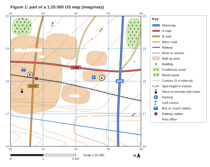
Study Figure 1, which is part of a 1:25 000 OS map of an imaginary area on the eastern edge of Hollinford, a UK city. The map was written for this course.
Compare the land use in grid square 4218 with the land use in grid square 4519.
Model answer
Square 4218 is almost entirely built-up, as it is part of Hollinford, whereas square 4519 has no built-up land and is mostly farmland and coniferous woodland. Square 4218 has services such as a railway station, a bus station and a post office, but square 4519 has none. Both squares contain main transport routes, but 4218 has an A road, a B road and the railway, while 4519 has the M71 motorway.
Explanation
Each mark needs a comparative statement using map evidence from both squares (built-up versus farmland and woodland, services versus none, different types of route). Find each square by its bottom-left corner: 4218 is inside the built-up area of Hollinford and 4519 is in the north-east of the map.
Mark scheme
1 mark
A first valid comparative statement, e.g. square 4218 is almost entirely built-up, whereas square 4519 is mainly farmland and woodland
Award one mark for each comparative point, up to 3. Map evidence: 4218 is about 100% built-up (part of Hollinford), with the A486, the B4120, the railway, a railway station, a bus station and a post office. 4519 has no built-up area; it is about half coniferous woodland, with open farmland, the M71 motorway and a minor road. Creditable comparisons: 4218 is built-up whereas 4519 is rural (farmland and woodland) (1). 4218 has services such as a railway station, bus station and post office, but 4519 has none (1). 4218 has woodland in none of the square, whereas about half of 4519 is coniferous woodland (1). Both squares have main transport routes, but 4218 has an A road, a B road and a railway while 4519 has the M71 motorway and a minor road (1). 4218 is inside the built-up area of Hollinford, whereas 4519 is in the countryside beyond the edge of the city (1). Accept any other appropriate comparison. Estimates of how much of each square is built-up or wooded need only be approximate.
1 mark
A second, different comparative statement
Do not credit two separate descriptions without a comparison (e.g. '4218 has a station. 4519 has a motorway.').
1 mark
A third, different comparative statement
Do not credit explanation of the differences.
Question 4
4 marks
Explain two ways in which new transport links can lead to growth in parts of a city.
Model answer
First, a new rail line makes an area much quicker to reach from the rest of the city. Businesses then choose to open offices there because their workers and customers can travel easily, so new jobs are created.
Second, developers build new homes near the new stations because people want to live where they can commute quickly. For example, new housing has been built near stations on the Elizabeth line in London, so the population of those areas has grown.
Explanation
Each way needs a link between better transport and growth (businesses moving in, new housing, rising investment) and a development explaining the result. Two ways must be clearly different, not the same idea in two forms.
Mark scheme
1 mark
Identifies a first way, e.g. improved accessibility attracts businesses and jobs / new homes are built near stations / land and property values rise, attracting investment / people can commute from further away
Examples: A new rail or tram line makes an area quicker to reach (1), so businesses open offices there and new jobs are created (1). Developers build new homes near the new stations (1) because people want to live where they can commute easily, so the population of the area grows (1). Property values rise near new stations (1), which encourages more investment in shops and services (1). Examples: the Elizabeth line (opened 2022) in London; the DLR and Jubilee line extension to Canary Wharf; Metrolink in Manchester. Accept any other appropriate response.
1 mark
Develops the first way
The development should explain how the transport link leads to economic or population growth.
1 mark
Identifies a second, different way
The two ways must be different (e.g. attracting businesses and attracting residents).
1 mark
Develops the second way
Allow any other appropriate development.
Ready to try the rest? Every answer you write is marked against the mark scheme, so you can see exactly where the marks are.
Ctrl + Enter to check
Study HelperHints first, answers after you try
Stuck on this one? Ask for a hint and I’ll point you in the right direction, without giving the answer away. Once you’ve checked your answer, I’ll show you how the marks are awarded.