Level:
Correct: 0
Incorrect: 0
Marks: 0/0
Exam Practice
Course:
Topics:
Edexcel GCSE Geography B (Paper 2) Smart practice A mixed round aimed at your weak spots
Unit 4
Topic 4: The UK's evolving physical landscape
Unit 5
Topic 5: The UK's evolving human landscape
Unit 6
Topic 6: Geographical investigations
Avg
score:
–
Topics
done:
0/28

Coastal landscapes of erosion: geology and processes

Practise 30 exam-style questions on Coastal landscapes of erosion: geology and processes for Edexcel GCSE Geography B (Paper 2). Write your answer as you would in the exam and get it marked in seconds against the mark scheme, point by point, with the Study Helper on hand if you get stuck.

  • 30 questions
  • 1–8 marks each
  • Instant marking
  • No sign-up needed
20 questions, marked as you go

Sample questions with model answers

Here are 4 of the questions in this topic, each with a model answer, an explanation of why it earns the marks and the mark scheme an examiner would use.

Question 1

1 mark

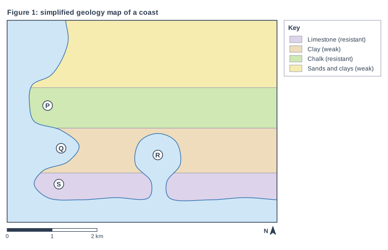
Study Figure 1, which is a simplified geology map of an imaginary stretch of coast (written for this course).

Identify the letter that marks a landform formed where the sea has broken through a band of resistant rock that runs parallel to the coast, and has then eroded the weaker rock behind it.

Choose your answer.

  • A P
  • B Q
  • C R
  • D S
Figure 1: simplified geology map of a coast. Map of a local area, 6 km from west to east and 4.5 km from south to north, with north at the top. The sea (pale blue) lies to the south-west; the coastline runs from the north edge to the east edge, passing through the south of the map. Areas: the limestone (resistant) shown purple, in the south of the map, in the sea; the clay (weak) shown tan, in the centre of the map; the chalk (resistant) shown green, in the centre of the map; the sands and clays (weak) shown yellow, in the north of the map. Letters in circles: P is in a circle in the west of the map; Q is in a circle in the west of the map; R is in a circle in the centre of the map; S is in a circle in the south-west of the map. The key (beside the map) shows: limestone (resistant), clay (weak), chalk (resistant), sands and clays (weak). Below the map: a scale bar marked 0, 1 and 2 km and a north arrow pointing to the top.

Model answer

C - R

Explanation

On the south coast the bands of rock run parallel to the coast (a concordant coastline), so the resistant limestone protects the clay behind it until the sea breaks through at a weakness and erodes a cove, as at R. P, Q and S are on the west coast, where the bands meet the coast at right angles (a discordant coastline) and form headlands and bays. A common error is to choose the bay at Q, which is also eroded in weak rock but did not need a breach in resistant rock first.

Mark scheme
  1. 1 mark

    C (R, the cove)

    Accept the letter or the option written out; do not credit more than one answer. R marks a cove on the south coast, where the band of resistant limestone runs parallel to the coast and the sea has broken through it at a narrow entrance and eroded the weak clay behind. A is incorrect: P is a headland of resistant chalk on the west coast, where the bands of rock meet the coast at right angles. B is incorrect: Q is a bay on the west coast, where the weak clay meets the coast directly, so the sea did not have to break through resistant rock first. D is incorrect: S is a headland of resistant limestone, which has not been broken through.
Question 2

2 marks

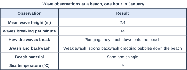
Figure 1 shows observations made by a student during one hour at a beach in January (data written for this course). The student concluded that the waves were destructive.

State two pieces of evidence from Figure 1 that support this conclusion.

Wave observations at a beach, one hour in January. Table with columns "Observation", "Result". Observation: Mean wave height (m); Result: 2.4 | Observation: Waves breaking per minute; Result: 14 | Observation: How the waves break; Result: Plunging: they crash down onto the beach | Observation: Swash and backwash; Result: Weak swash; strong backwash dragging pebbles down the beach | Observation: Beach material; Result: Sand and shingle | Observation: Sea temperature (°C); Result: 9.

Model answer

The mean wave height was 2.4 m, which is high. The backwash was stronger than the swash and dragged pebbles back down the beach.

Explanation

Destructive waves are high, steep and frequent, plunge onto the beach and have a backwash stronger than the swash, so they remove sediment. Each mark needs a different observation from Figure 1 that shows one of these characteristics; the beach material and the sea temperature do not show the type of wave.

Mark scheme
  1. 1 mark

    One piece of evidence from Figure 1, e.g. the waves are high (2.4 m) / many waves break each minute (14) / the waves plunge (crash down) onto the beach / the swash is weak and the backwash strong / the backwash drags pebbles down the beach (sediment is removed)

    Award 1 mark for each different piece of evidence from Figure 1, up to 2. The figures need not be quoted, but the evidence must come from Figure 1. 'Weak swash' and 'strong backwash' count as one piece of evidence. Do not credit the beach material or the sea temperature, which do not show the type of wave, or characteristics with no support in Figure 1. Accept any other appropriate response drawn from Figure 1.

  2. 1 mark

    A second, different piece of evidence from Figure 1

Question 3

2 marks

Explain one reason why a single severe storm can cause more cliff retreat than several years of calm weather.

Model answer

Storm waves are much higher and more powerful than the waves in calm weather, and a storm surge can raise the sea level so that they reach the foot of the cliff. Hydraulic action and abrasion then undercut the cliff in a few hours, so a large section of it can collapse at once.

Explanation

Cliff retreat is not steady: much of it happens in short, high-energy events. One mark is for a feature of the storm (bigger waves, a surge, loss of the beach) and one for explaining how it causes rapid erosion or collapse. A common error is to describe the storm without linking it to the cliff.

Mark scheme
  1. 1 mark

    Identifies a reason, e.g. storm waves are much higher and more powerful / a storm surge raises the sea level so waves reach the cliff foot / storm waves remove the beach that protects the cliff / storm waves undercut the cliff so it collapses suddenly

    Examples: Storm waves are much higher and carry far more energy than calm-weather waves (1) so hydraulic action and abrasion remove more rock from the cliff foot in a few hours (1). A storm surge raises the sea level (1) so waves reach above the beach and attack the foot of the cliff, which calm-weather waves do not reach (1). Destructive storm waves drag the beach away from the cliff foot (1) leaving the cliff exposed to direct wave attack (1). Storm waves undercut the cliff (1) so a large section collapses at once and several metres can be lost in one event (1). Accept any other appropriate response.

  2. 1 mark

    Develops the reason, linking it to rapid erosion or collapse of the cliff

    The development must explain why the storm causes a large amount of retreat. Do not credit 'storms are stronger' repeated as the development.

Question 4

4 marks

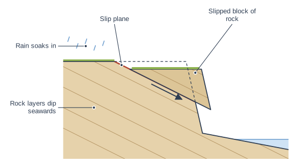
Figure 1 is a cross-section of a cliff in which the layers of rock dip (slope) down towards the sea.

Explain how the rock structure shown in Figure 1 makes this cliff likely to experience mass movement.

Cross-section of a cliff. Cross-section of a cliff made of layers of rock that slope down towards the sea: land on the left, the beach and sea on the right. Raindrops fall on the land. A wedge-shaped block of rock has moved down a straight, sloping line, which is exposed behind it; the block's front now overhangs the lower cliff. A straight arrow on the block points down the slope, parallel to the line, and a dashed outline shows the block's earlier position. The label "Rain soaks in" points to the raindrops above the land on the left; the label "Rock layers dip seawards" points to the parallel lines in the rock, sloping down towards the sea; the label "Slip plane" points to the straight, sloping line along which the block has moved, exposed behind the block; the label "Slipped block of rock" points to the wedge-shaped block of rock that has moved down the sloping line, its front now overhanging the lower cliff.

Model answer

The layers of rock dip down towards the sea, so the bedding planes between them slope seawards and act as planes of weakness. Gravity can pull a block of rock down along one of these sloping planes. Rain soaks into the cliff and seeps along the bedding planes, lubricating them and making the rock heavier, so friction is reduced. When waves undercut the base of the cliff, the layers above lose their support and a block slides down the slip plane onto the beach.

Explanation

Rock structure matters as well as rock type: layers that dip towards the sea give ready-made slip planes for sliding. The best answers link the structure to the processes (gravity, lubrication by water, undercutting by waves).

Mark scheme
  1. 1 mark

    Identifies a feature of the structure, e.g. the bedding planes slope down towards the sea

    Award marks for each valid point and its development, up to 4 in total. Examples: The layers of rock (bedding planes) slope towards the sea (1) so blocks of rock can slide down along them, with gravity pulling them seawards (1). The bedding planes are lines of weakness between the layers (1) along which a block can break away as a slide (1). Rain soaks into the cliff and seeps along the bedding planes (1), lubricating them and adding weight, so friction is reduced and blocks slide (1). Waves erode the base of the cliff (1) removing support from the layers above, so they slide down the slip plane (1). Accept any other appropriate response.

  2. 3 marks

    Up to 3 further marks for development, e.g. blocks slide down the sloping bedding planes; water lubricates the planes and adds weight; undercutting by waves removes support

    Development marks must link to the structure: points about rain or waves are credited when they explain how water or undercutting makes blocks move along the sloping bedding planes.

Ready to try the rest? Every answer you write is marked against the mark scheme, so you can see exactly where the marks are.

Study Helper Hints first, answers after you try

Stuck on this one? Ask for a hint and I’ll point you in the right direction, without giving the answer away. Once you’ve checked your answer, I’ll show you how the marks are awarded.