River erosion, transport, deposition and landforms
Practise 28 exam-style questions on River erosion, transport, deposition and landforms for Edexcel GCSE Geography B (Paper 2). Write your answer as you would in the exam and get it marked in seconds against the mark scheme, point by point, with the Study Helper on hand if you get stuck.
28 questions
1–8 marks each
Instant marking
No sign-up needed
20 questions, marked as you go
Sample questions with model answers
Here are 4 of the questions in this topic, each with a model answer, an explanation of why it earns the marks and the mark scheme an examiner would use.
Question 1
1 mark
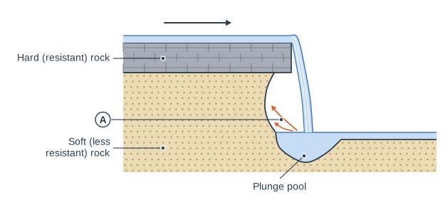
Figure 1 shows a cross-section through a waterfall.
Name one process of erosion shown by the arrows labelled A.
Model answer
Hydraulic action
Explanation
The arrows show water splashing back from the plunge pool against the soft rock: the force of the water (hydraulic action) and the rocks it carries (abrasion) wear the soft rock away, undercutting the hard rock above. 'Undercutting' describes the result, not the process.
Mark scheme
1 mark
Hydraulic action / abrasion (corrasion)
The arrows show splashback and swirling water from the plunge pool eroding the soft rock behind the falling water. Accept either hydraulic action or abrasion (corrasion), or a clear description of either (e.g. 'the force of the water hitting the rock' or 'rocks thrown against the soft rock'). Do not credit 'undercutting' or 'erosion' on its own, which do not name a process, or attrition, which wears down the load rather than the rock face.
Question 2
2 marks
Explain one reason why interlocking spurs form in the upper course of a river.
Model answer
In the upper course the river uses most of its energy to erode vertically, so it cannot erode sideways through the hillsides. It therefore winds around them, leaving spurs of land that stick out from alternate sides of the valley and interlock.
Explanation
The first mark is for vertical rather than lateral erosion (or the river avoiding resistant rock) and the second for explaining how the river winding round the hillsides leaves spurs on alternate sides. Describing what interlocking spurs look like does not explain them.
Mark scheme
1 mark
Identifies a reason, e.g. the river erodes mainly vertically and has little energy for lateral (sideways) erosion
Examples: In the upper course the river erodes mainly downwards (vertically) (1) and does not have the energy to erode sideways through the hillsides, so it winds around them, leaving spurs that interlock (1). The river flows around areas of harder, more resistant rock (1) because it cannot erode through them, so these stick out as spurs from alternate sides of the valley (1). Accept any other appropriate response.
1 mark
Develops the reason, e.g. the river winds around the projecting hillsides, which are left as spurs on alternate sides of the valley
Do not credit a description of interlocking spurs with no reason.
Question 3
3 marks
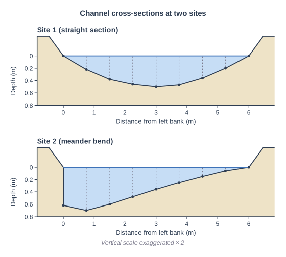
Figure 1 shows channel cross-sections measured by a group of students at a straight section of a river (Site 1) and at a meander bend (Site 2) (data written for this course). At Site 2 the left bank is on the outside of the bend.
Compare the channel cross-section at Site 1 with the channel cross-section at Site 2.
Use data from Figure 1 in your answer.
Model answer
The cross-section at Site 1 is roughly symmetrical, whereas at Site 2 it is asymmetrical. Site 2 is deeper, about 0.7 m at its deepest compared with 0.5 m at Site 1. The deepest point at Site 1 is in the middle of the channel, but at Site 2 it is right next to the left bank, which is a vertical cliff about 0.6 m deep, while the right side slopes up gently.
Explanation
Each mark needs a comparison of the two sites, and full marks need data such as depths or distances from the bank. Explaining why the bend is deeper on the outside is not asked for and earns nothing.
Mark scheme
1 mark
First comparative point, e.g. Site 1 is symmetrical whereas Site 2 is asymmetrical
Max 2 if no data from Figure 1 is used. Award 1 mark for each comparative point, up to 3 marks. Points: Site 1 is roughly symmetrical whereas Site 2 is asymmetrical (1); Site 2 is deeper, with a maximum depth of about 0.7 m compared with 0.5 m at Site 1 (1); the deepest point at Site 1 is in the middle (about 3 m from the left bank) whereas at Site 2 it is close to the left bank (about 0.75 m) (1); at Site 2 the left bank is a vertical cliff about 0.6 m deep below the water, whereas at Site 1 both banks slope gently from 0 m (1); the right side of Site 2 is shallower and more gently sloping than at Site 1 (e.g. 0.06 m against 0.2 m deep 0.75 m from the right bank) (1); both channels are the same width, 6 m (1).
1 mark
Second comparative point
Do not credit explanation (e.g. 'because the fastest flow is on the outside of the bend'). Do not credit separate descriptions of each site with no comparison.
1 mark
Third comparative point
Accept depths within 0.1 m and distances within 0.5 m of those given (half a scale interval either side). Accept any other appropriate response.
Question 4
4 marks
Explain one reason why a river deposits sediment on the inside of a meander bend and one reason why it deposits sediment where it enters the sea.
Model answer
Inside of the bend: the fastest flow swings to the outside of the bend, so the water on the inside is shallow and slow. Friction with the bed is greater there, so the river has too little energy to carry its load and deposits sand and gravel, building a slip-off slope. River mouth: when the river meets the sea, its flow is checked by the sea water, so its velocity falls sharply. It no longer has the energy to carry its load, so the sediment is dropped. In salt water, tiny clay particles also stick together and sink.
Explanation
Each half earns 1 mark for the reason and 1 for linking it to a loss of energy (or to flocculation) that makes the river drop its load. A common error is to give the same general reason, 'the river slows down', for both places without explaining why it slows down in each.
Mark scheme
1 mark
Inside of the bend: reason identified, e.g. the water there is shallow and slow-flowing
Examples (inside of the bend): The fastest flow swings to the outside of the bend, so the water on the inside is shallow and slow (1); friction with the bed is greater there, so the river has too little energy to carry its load and drops sand and gravel, building a slip-off slope (point bar) (1). Water flowing round the bend in a corkscrew motion (helicoidal flow) carries sediment across the bed from the outer bank (1) and drops it on the inside, where the flow is weakest (1). Accept any other appropriate response.
1 mark
Development: links the slow flow / low energy on the inside of the bend to deposition
Do not credit 'the river is slower' without saying why it is slower on the inside of the bend or why this leads to deposition.
1 mark
River mouth: reason identified, e.g. the river's velocity falls sharply where it meets the sea
Examples (river mouth): When the river meets the sea its flow is checked by the still or incoming tidal water (1), so its velocity falls sharply and it no longer has the energy to carry its load, which is dropped (1). In salt water tiny clay particles stick together (flocculate) (1), becoming heavy enough to sink to the bed (1). The gradient is very gentle near the mouth (1), so the river has little energy to carry its load (1). Accept any other appropriate response.
1 mark
Development: links the loss of energy (or flocculation) at the mouth to deposition
Each reason must be explained for its own place. Do not credit 'the river gets tired' or 'the river stops' without explanation.
Ready to try the rest? Every answer you write is marked against the mark scheme, so you can see exactly where the marks are.
Ctrl + Enter to check
Study HelperHints first, answers after you try
Stuck on this one? Ask for a hint and I’ll point you in the right direction, without giving the answer away. Once you’ve checked your answer, I’ll show you how the marks are awarded.