Practise 30 exam-style questions on Weather hazards in the UK for AQA GCSE Geography (Paper 1). Write your answer as you would in the exam and get it marked in seconds against the mark scheme, point by point, with an AI tutor on hand if you get stuck.
30 questions
1–12 marks each
Instant marking
No sign-up needed
20 questions, marked as you go
Sample questions with model answers
Here are 4 of the questions in this topic, each with a model answer, an explanation of why it earns the marks and the mark scheme an examiner would use.
Question 1
1 mark
Give one way in which people in the UK are warned about extreme weather.
Model answer
The Met Office issues yellow, amber and red weather warnings.
Explanation
Warnings are a key management strategy because they give people time to prepare, change plans or evacuate. The colour shows the level of risk: in July 2022 the Met Office issued its first ever red warning for extreme heat.
Mark scheme
1 mark
Met Office weather warnings (yellow, amber or red) / Environment Agency flood warnings / heat-health alerts / forecasts and warnings on TV, radio, websites, apps or text messages
Any one valid method. Accept 'weather forecasts'.
Question 2
2 marks
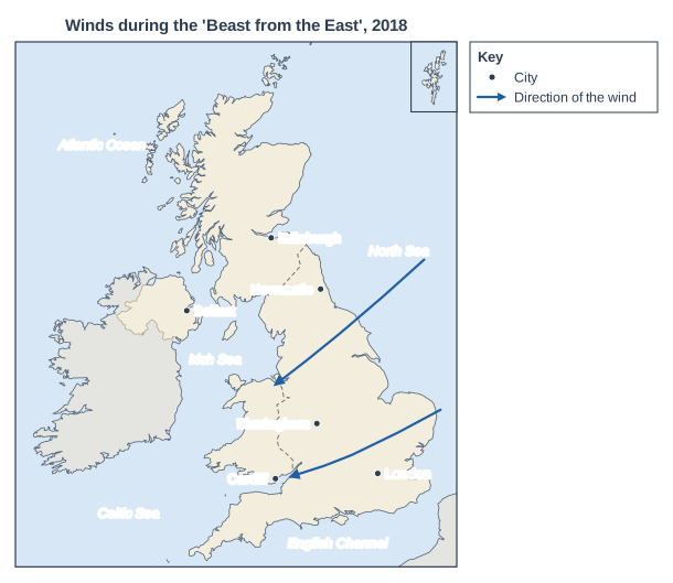
Figure 1 shows the direction of the winds that brought very cold weather to the UK in late February and early March 2018, an event known as the 'Beast from the East'.
State the direction the winds came from and suggest why the air was so cold.
Model answer
The winds came from the east. The air had travelled from Russia and Siberia, where the land is extremely cold and snow-covered in winter, so it was bitterly cold by the time it reached the UK.
Explanation
Wind direction is the direction the wind comes from: the arrows start over the North Sea and point west, so the winds are easterly. Normally the UK's winds come from the Atlantic, which is mild in winter; easterly winds instead bring cold air from the continent.
Mark scheme
1 mark
From the east / north-east (easterly winds)
Do not accept 'towards the west' or 'from the west'.
1 mark
The air came from Russia / Siberia / mainland Europe, which is very cold in winter (snow-covered land), so the air was very cold and only crossed a short stretch of sea
Accept 'polar continental air'.
Question 3
4 marks
Suggest why weather in the UK may be becoming more extreme.
Model answer
The main reason is likely to be climate change. As average temperatures rise, heatwaves become hotter and more frequent, which is why the UK reached 40 °C for the first time in 2022. Warmer air can hold more water vapour, so when depressions arrive the rain can be heavier, increasing the risk of flooding. Some scientists also suggest that the jet stream may become wavier and slower, so that weather patterns stay in place for longer, giving long periods of rain or long hot, dry spells. Natural variations in the climate also mean some years are unusually extreme.
Explanation
Suggest questions reward reasoned ideas. 'Global warming' on its own is Level 1; Level 2 answers explain how warming changes the weather, such as warmer air holding more moisture and causing heavier rain.
Mark scheme
4 marks
Levels of response (4 marks). Level 2 (3-4 marks): clear suggestions linking climate change (and/or other factors) to specific changes in UK weather, such as hotter summers or heavier rainfall, with the processes explained. Level 1 (1-2 marks): basic suggestions, e.g. 'because of global warming', with little explanation of how this affects the weather. 0 marks: nothing worthy of credit.
Indicative content (not a checklist; credit other valid points): climate change is raising average temperatures, so heatwaves are hotter and more frequent and records are broken (e.g. 40.3 °C in 2022); warmer air can hold more water vapour (about 7% more for each 1 °C), so when it rains, rainfall can be heavier, increasing flooding; warmer seas provide more energy and moisture to storms and depressions; some scientists suggest changes to the jet stream may make it wavier or slower, so weather patterns get 'stuck', giving long spells of rain or long heatwaves and droughts; natural variations (e.g. in the North Atlantic) also cause unusual years; better instruments, more weather stations and more media coverage may also make extreme events seem more common.
Question 4
6 marks
Using a named example, explain the causes of a recent extreme weather event in the UK.
Model answer
Storm Desmond struck Cumbria on 5-6 December 2015. It was a deep depression that brought a long stream of very warm, moist air from the subtropical Atlantic towards the UK on strong south-westerly winds. When this moist air reached Cumbria it was forced to rise over the mountains of the Lake District. As it rose it cooled and the water vapour condensed, producing torrential relief rainfall that continued for more than a day. Honister Pass received 341.4 mm of rain in 24 hours, a UK record.
Conditions on the ground made the flooding worse. November 2015 had already been very wet, so the soil was saturated and could not absorb any more water. The rain therefore ran off the steep, rocky slopes very quickly into rivers such as the Eden, the Kent and the Derwent. These rivers rose rapidly and burst their banks, flooding towns including Carlisle, Kendal, Keswick and Appleby. In Carlisle the water even overtopped flood defences that had been built after earlier floods in 2005.
Explanation
A Level 3 answer explains the weather (the depression, the moist south-westerly air, relief rainfall) and the conditions that turned the rain into a flood (saturated ground, steep slopes, rivers that could not cope), with accurate details of the named event.
Mark scheme
6 marks
Levels of response (6 marks). Level 3 (5-6 marks): detailed, well-developed explanation of the physical causes of a named recent UK extreme weather event (and any human factors that made it worse), with the causes clearly linked; detailed, accurate place-specific knowledge. Level 2 (3-4 marks): clear explanation of some causes with some links and some place-specific detail. Level 1 (1-2 marks): basic statements about causes, e.g. 'it rained a lot', with little explanation; generic. 0 marks: nothing worthy of credit.
Indicative content (not a checklist; credit other valid points): Somerset Levels floods (winter 2013-14): a series of depressions from the Atlantic, driven by a strong jet stream, gave the wettest winter on record; the ground became saturated, so rain ran straight into rivers; high tides and storm surges stopped the rivers Parrett and Tone draining to the sea; the Levels are flat and low-lying, some land close to sea level, so water could not drain away; the rivers had not been dredged for about 20 years, so silt reduced the amount of water they could carry. Storm Desmond (Cumbria, December 2015): a deep depression brought a long stream of warm, moist air from the subtropics on strong south-westerly winds; the air was forced to rise over the Cumbrian mountains, giving heavy relief rainfall (a record 341.4 mm in 24 hours at Honister Pass); the ground was already saturated after a wet November, and steep slopes sent water quickly into rivers such as the Eden, Kent and Derwent. 'Beast from the East' (2018): a sudden warming high above the Arctic disrupted the usual circulation; high pressure over Scandinavia drove very cold easterly winds from Russia and Siberia; the air picked up moisture over the North Sea and dropped it as snow; Storm Emma moving up from the south met the cold air, giving heavy snow and blizzards in the south-west and Wales. July 2022 heatwave: high pressure brought clear skies and drew a plume of very hot air north from North Africa and Spain; dry ground heated quickly; climate change made such extreme temperatures much more likely. Credit any appropriate named example.
Ready to try the rest? Every answer you write is marked against the mark scheme, so you can see exactly where the marks are.
Ctrl + Enter to check
AI TutorHints first, answers after you try
Hi! Stuck? Ask me for a hint and I’ll help you work it out. Once you’ve checked your answer I can explain exactly where the marks are.