Practise 32 exam-style questions on Glacial landforms for AQA GCSE Geography (Paper 1). Write your answer as you would in the exam and get it marked in seconds against the mark scheme, point by point, with an AI tutor on hand if you get stuck.
32 questions
1–12 marks each
Instant marking
No sign-up needed
20 questions, marked as you go
Sample questions with model answers
Here are 4 of the questions in this topic, each with a model answer, an explanation of why it earns the marks and the mark scheme an examiner would use.
Question 1
1 mark
Which one of the following types of moraine forms where two glaciers join?
A Terminal moraine B Lateral moraine C Medial moraine D Ground moraine
Give the letter of the correct answer.
Model answer
C – medial moraine.
Explanation
When two valley glaciers meet, the lateral moraines along their touching edges join together and are carried down the middle of the combined glacier as a medial moraine. Terminal moraine forms at the snout, lateral moraine along the sides and ground moraine across the valley floor.
Mark scheme
1 mark
C (medial moraine)
Accept the letter or the option written out; do not accept more than one answer.
Question 2
2 marks
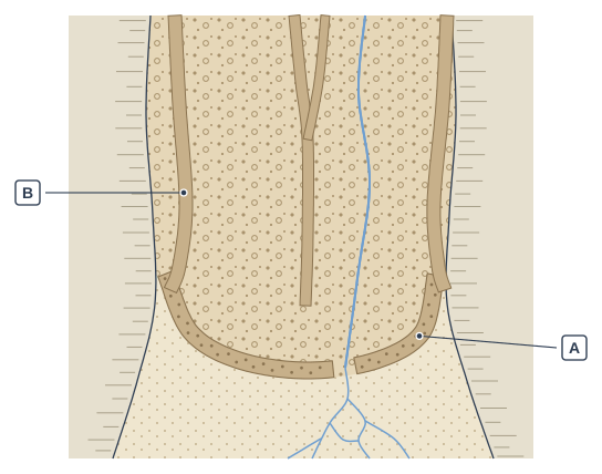
Figure 1 is a plan view of a valley after a glacier has melted.
Name the types of moraine labelled A and B.
Model answer
A is terminal moraine. B is lateral moraine.
Explanation
Terminal moraine (A) is the curved ridge across the valley marking the furthest point the glacier reached. Lateral moraine (B) is the ridge along the side of the valley, made of debris that fell onto the edges of the glacier from the valley sides.
Mark scheme
1 mark
A: terminal moraine
Accept end moraine.
1 mark
B: lateral moraine
Question 3
4 marks
Explain how erratics are formed and why they are useful to geographers.
Model answer
Erratics are rocks that have been moved by ice. A piece of rock is plucked from the bedrock, or falls onto the glacier after freeze-thaw weathering, and is then carried along by the ice, sometimes for many kilometres. When the ice melts, the rock is dropped, often on bedrock of a completely different type. Erratics are useful because a boulder that does not match the local rock shows that the area was once covered by ice. By matching the erratic to the place where that rock type is found, geographers can work out the direction in which the ice moved and how far it carried material. For example, the Norber erratics in the Yorkshire Dales are dark sandstone boulders resting on limestone.
Explanation
Cover both parts: formation (erosion, transport by ice, deposition when it melts) and usefulness (evidence of glaciation and of the direction of ice movement). A named example such as the Norber erratics strengthens the answer.
Mark scheme
4 marks
Levels of response (4 marks). Level 2 (3-4 marks): clear explanation of how erratics are eroded, transported and deposited by ice, and of how they provide evidence of past glaciation and ice movement; linked points; accurate terminology; may use a named example. Level 1 (1-2 marks): basic statements, e.g. 'a rock moved by a glacier'; little explanation of why they are useful. 0 marks: nothing worthy of credit.
Indicative content (not a checklist; credit other valid points): formation: rock is broken off by plucking or falls onto the glacier after freeze-thaw weathering; the glacier carries it, sometimes many kilometres, on, in or beneath the ice; ice can carry very large boulders without sorting them; when the ice melts the rock is deposited, often on bedrock of a different type; usefulness: an erratic of a different rock type from the local bedrock shows the area was once covered by ice; by matching the erratic to its source rock, geographers can work out the direction the ice moved and how far it travelled; examples: the Norber erratics in the Yorkshire Dales (dark sandstone boulders resting on limestone); Shap granite erratics carried from Shap in Cumbria across northern England.
Question 4
6 marks
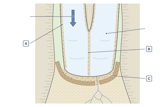
Figure 1 is a plan view of a valley glacier.
Using Figure 1, explain the formation of the types of moraine labelled A, B and C.
Model answer
All moraines are made of unsorted debris carried and deposited by the glacier.
Lateral moraine (A) forms along the edges of the glacier. Freeze-thaw weathering breaks rock off the steep valley sides, and it falls onto the edges of the ice; the glacier also erodes its own sides. This debris is carried along as a band at the edge of the glacier and is left as a ridge along the valley side when the ice melts.
Medial moraine (B) forms where two glaciers join. In Figure 1, a tributary glacier joins the main glacier from the top right. The lateral moraines on the edges where the two glaciers meet merge into one band of debris, which is carried down the middle of the combined glacier and is left as a ridge along the middle of the valley when the ice melts.
Terminal moraine (C) forms at the snout. Here the ice melts and deposits the debris it has been carrying, and when the glacier advances it also bulldozes material in front of it. If the snout stays in the same place for a long time, a large ridge of debris builds up across the valley. This terminal moraine marks the furthest point the glacier reached.
Explanation
For each type of moraine, explain where the debris comes from, how it is carried and where it is deposited. Medial moraine needs two glaciers joining, and terminal moraine marks the maximum advance - linking these to the figure is what reaches Level 3.
Mark scheme
6 marks
Levels of response (6 marks). Level 3 (5-6 marks): detailed, well-developed explanation of the formation of lateral (A), medial (B) and terminal (C) moraine, with accurate sources of debris and processes of transport and deposition for each; effective use of Figure 1; accurate terminology. Level 2 (3-4 marks): clear explanation of two types of moraine, or of all three with less detail; some use of Figure 1. Level 1 (1-2 marks): basic statements, e.g. naming the moraines or saying 'debris is dropped by the glacier'; little explanation. 0 marks: nothing worthy of credit.
Indicative content (not a checklist; credit other valid points): moraine is unsorted debris (till) carried and deposited by a glacier; A lateral moraine: freeze-thaw weathering of the valley sides breaks off rock, which falls onto the edges of the glacier; the glacier also erodes its sides; this debris is carried along the edges of the ice as a band; when the ice melts it is left as a ridge along the valley side; B medial moraine: where a tributary glacier joins the main glacier (top right in Figure 1), their touching lateral moraines merge; the combined band is carried down the middle of the glacier; when the ice melts it is left as a ridge along the middle of the valley floor; C terminal moraine: at the snout the glacier melts and deposits the debris it carries; as it advances it also bulldozes material ahead of it; where the snout stays in the same position for a long time, debris builds up into a ridge across the valley; it marks the furthest point the glacier reached; recessional moraines form where the snout paused as the glacier retreated; ground moraine is spread across the valley floor between them.
Ready to try the rest? Every answer you write is marked against the mark scheme, so you can see exactly where the marks are.
Ctrl + Enter to check
AI TutorHints first, answers after you try
Hi! Stuck? Ask me for a hint and I’ll help you work it out. Once you’ve checked your answer I can explain exactly where the marks are.