OS maps: grid references, scale, distance and direction
Practise 30 exam-style questions on OS maps: grid references, scale, distance and direction for AQA GCSE Geography (Paper 1). Write your answer as you would in the exam and get it marked in seconds against the mark scheme, point by point, with an AI tutor on hand if you get stuck.
30 questions
1–6 marks each
Instant marking
No sign-up needed
20 questions, marked as you go
Sample questions with model answers
Here are 4 of the questions in this topic, each with a model answer, an explanation of why it earns the marks and the mark scheme an examiner would use.
Question 1
1 mark
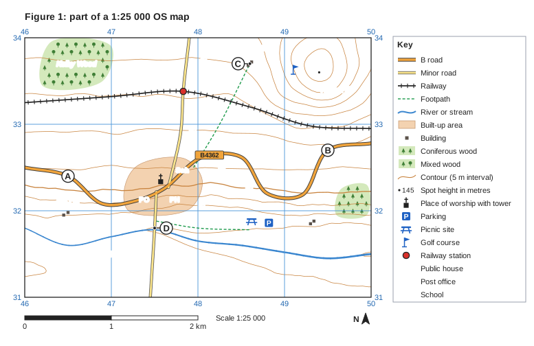
Study Figure 1, part of a 1:25 000 OS map.
What is found at grid reference 473321?
Model answer
A post office in the village of Kelby.
Explanation
Split the reference into 473 (easting 47, three tenths east) and 321 (northing 32, one tenth north). That point is the PO symbol in Kelby. Students who swap the eastings and northings, or who misjudge the tenths, often pick the public house instead.
Mark scheme
1 mark
A post office (PO), in Kelby
accept 'PO'; do not accept the public house (477321), the church or the school
Question 2
2 marks
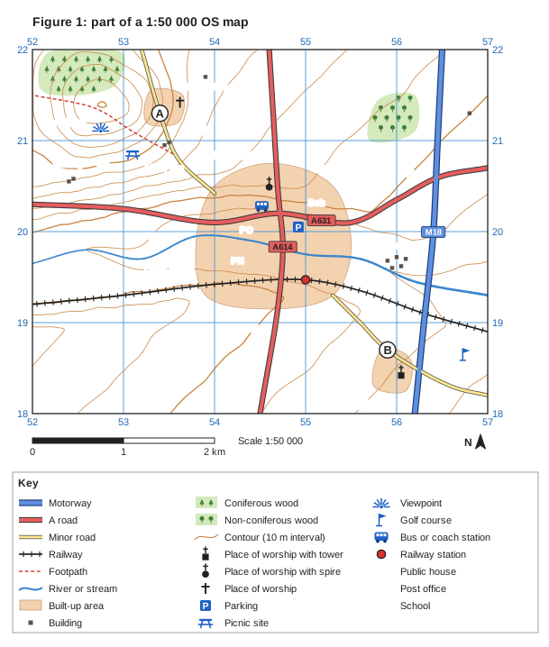
Study Figure 1, part of a 1:50 000 OS map.
Estimate the area covered by the built-up area of Haverley. Show your method.
Model answer
Each grid square is 1 km². Haverley covers parts of six squares (5319, 5320, 5419, 5420, 5519 and 5520); adding the parts together gives about 2.3 km².
Explanation
Every grid square on an OS map is 1 km by 1 km, so it covers 1 km² at any scale. Count the squares that are completely covered, then estimate and add the fractions of the partly covered squares. Answers without km² as the unit, or that simply count every square touched (6 km²), overestimate the area.
Mark scheme
1 mark
Method: counting the whole grid squares and adding the parts of squares covered by the built-up area, where each grid square is 1 km²
credit a clear description of the method or working such as 'about 1 whole square plus parts of 5 others'
1 mark
About 2.3 km²
accept 2-3 km²; units (km²) required
Question 3
3 marks
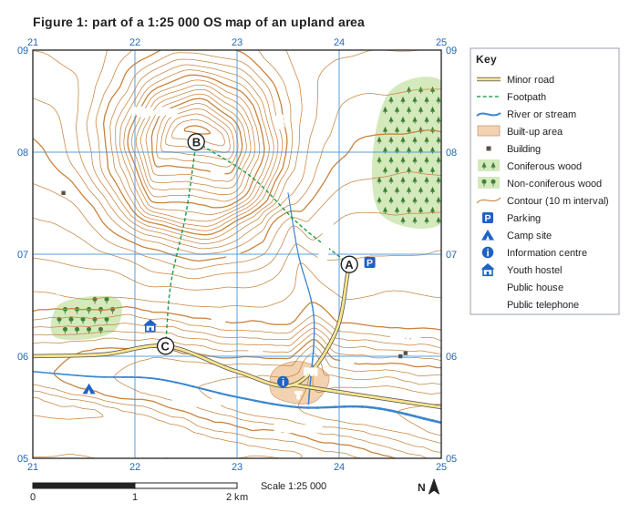
Study Figure 1, part of a 1:25 000 OS map of an upland area.
Give the six-figure grid reference of the youth hostel, the straight-line distance in kilometres from C to B, and the direction of B from C using an eight-point compass.
Model answer
The youth hostel is at 221063. The straight-line distance from C to B is 2.0 km, and B is north of C.
Explanation
Each part tests a different skill: a six-figure reference (eastings first, then northings, each with tenths), a straight-line measurement against the scale bar (4 cm = 1 km at 1:25 000), and a direction measured from the starting point C towards B.
Mark scheme
1 mark
Youth hostel: 221063
accept 220-222 for the first three figures and 062-064 for the last three
1 mark
Distance from C to B: 2.0 km (2022 m)
accept 1.9-2.1 km
1 mark
Direction of B from C: north (N)
B is on a bearing of about 009° from C; do not accept south (the reverse direction)
Question 4
4 marks
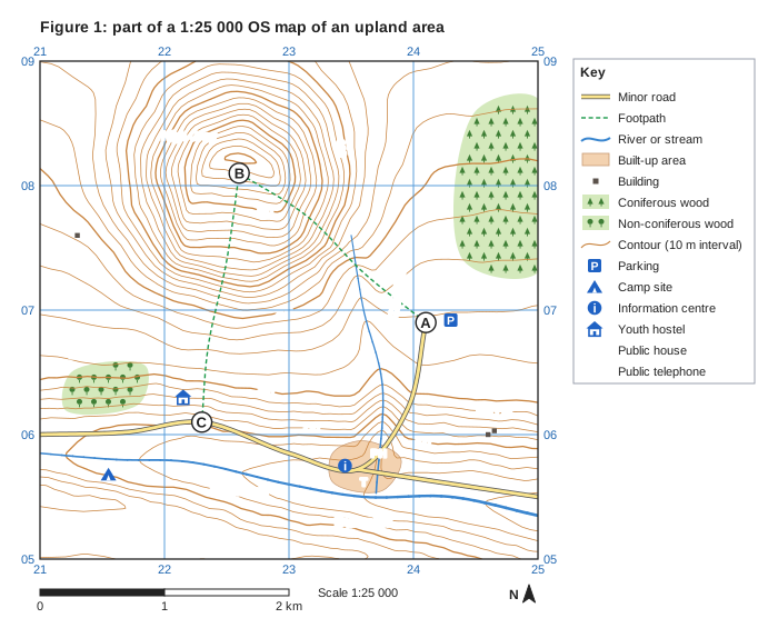
Study Figure 1, part of a 1:25 000 OS map of an upland area.
Using map evidence, suggest two reasons why the youth hostel was built where it is.
Model answer
The youth hostel at 221063 is right next to the start of the footpath up High Crag at C. This makes it an ideal base for walkers who want to climb to the summit at about 503 m, only 2 km to the north.
It is also beside the minor road along the Black Burn valley, so visitors can reach it easily by car, bike or bus, and it is only about 1.5 km from Burnside, which has a public house and an information centre for visitors.
Explanation
Youth hostels are built where walkers want to go and where they can be reached. Each reason earns a second mark when it is linked to specific map evidence, such as the footpath, the road, the summit height or the services in Burnside.
Mark scheme
1 mark
First reason, e.g. it is next to the start of the footpath up High Crag at C / it is beside the minor road along the valley / it is in the valley near the village of Burnside / it is on fairly gentle land in the sheltered valley
max 4: for each of two different reasons, 1 mark for the reason and 1 for developing it or supporting it with map evidence
1 mark
Development of the first reason, e.g. so it is an ideal base for walkers climbing High Crag (503 m), about 2 km to the north; so visitors can arrive easily by car, bike or bus and supplies can be delivered
development of the previous point
1 mark
Second, different reason
1 mark
Development of the second reason, e.g. Burnside (about 1.5 km to the east) has a public house, an information centre and a telephone for visitors; the land at about 230 m is gentle enough to build on and sheltered compared with the summit; the camp site (215056), Black Wood and Black Burn nearby offer other activities
credit other reasonable suggestions supported by map evidence
Ready to try the rest? Every answer you write is marked against the mark scheme, so you can see exactly where the marks are.
Ctrl + Enter to check
AI TutorHints first, answers after you try
Hi! Stuck? Ask me for a hint and I’ll help you work it out. Once you’ve checked your answer I can explain exactly where the marks are.