Level:
Correct: 0
Incorrect: 0
Marks: 0/0
Exam Practice
Subject:
Topics:
AQA GCSE Geography (Paper 1) Smart practice A mixed round aimed at your weak spots
Unit 1
The challenge of natural hazards
Unit 2
The living world
Unit 3
Physical landscapes in the UK
Unit 4
Geographical skills: OS maps
Avg
score:
–
Topics
done:
0/32

Coastal management

Practise 30 exam-style questions on Coastal management for AQA GCSE Geography (Paper 1). Write your answer as you would in the exam and get it marked in seconds against the mark scheme, point by point, with an AI tutor on hand if you get stuck.

  • 30 questions
  • 1–12 marks each
  • Instant marking
  • No sign-up needed
20 questions, marked as you go

Sample questions with model answers

Here are 4 of the questions in this topic, each with a model answer, an explanation of why it earns the marks and the mark scheme an examiner would use.

Question 1

1 mark

Which one of the following hard engineering strategies works by trapping sediment that is being moved by longshore drift?

A Groynes
B Sea wall
C Gabions
D Rock armour

Give the letter of the correct answer.

Model answer

A - groynes.

Explanation

Groynes are timber or rock barriers built at right angles to the beach. They trap sediment moved by longshore drift, building a wider beach that absorbs wave energy. Sea walls, gabions and rock armour protect the land directly by resisting or absorbing wave energy.

Mark scheme
  1. 1 mark

    A (groynes)

    accept the letter or the option written out; do not accept more than one answer

Question 2

2 marks

For a coastal management scheme in the UK you have studied, state two management strategies that were used.

Model answer

At Mappleton on the Holderness coast, two rock groynes were built and rock armour was placed along the foot of the cliff.

Explanation

Case-study questions need accurate detail for the scheme you name. Mappleton (1991) used rock groynes and rock armour; Medmerry (2013) used managed realignment, with new embankments inland and a breach in the old shingle bank. Generic strategies with no named place do not score.

Mark scheme
  1. 1 mark

    One strategy accurately linked to the named scheme, e.g. Mappleton: rock groynes; Medmerry: new embankments built inland; Lyme Regis: new sea wall

    max 2; 1 mark per accurate strategy; the scheme must be named and the strategies must be accurate for it; credit any appropriate named example

  2. 1 mark

    A second accurate strategy, e.g. Mappleton: rock armour (revetment) at the foot of the cliff; Medmerry: breaching the shingle bank to flood farmland (managed realignment); Lyme Regis: beach nourishment, rock armour or cliff stabilisation

Question 3

4 marks

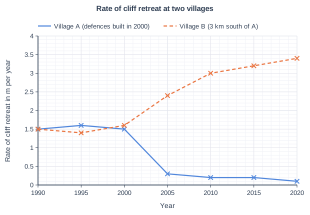
Figure 1 shows the rate of cliff retreat at two villages on a soft-rock coast, where longshore drift moves sediment from north to south. Groynes and rock armour were built at Village A in 2000. Village B is 3 km south of Village A.

Using Figure 1, describe the changes in the rate of cliff retreat at the two villages and suggest reasons for them.

Rate of cliff retreat at two villages. Line graph of rate of cliff retreat in m per year (y-axis, 0 to 4) against year (x-axis, 1990 to 2020). "Village A (defences built in 2000)" joins the points (1990, 1.5), (1995, 1.6), (2000, 1.5), (2005, 0.3), (2010, 0.2), (2015, 0.2), (2020, 0.1). "Village B (3 km south of A)" (dashed) joins the points (1990, 1.5), (1995, 1.4), (2000, 1.6), (2005, 2.4), (2010, 3), (2015, 3.2), (2020, 3.4).

Model answer

Before 2000 the cliffs at both villages retreated at about 1.5 m a year. After the defences were built at Village A in 2000, its rate of retreat fell sharply to about 0.3 m a year by 2005 and to about 0.1 m a year by 2020. At Village B the opposite happened: the rate increased to about 2.4 m a year by 2005 and about 3.4 m a year by 2020, more than twice the rate before 2000.

The rock armour at Village A absorbs wave energy at the foot of the cliffs, and the groynes trap sediment carried south by longshore drift, building a wider beach that protects the cliffs. Because the sediment is trapped at Village A, less reaches Village B, so its beach becomes narrower and its cliffs are attacked by more powerful waves. This is similar to what happened at Mappleton and Cowden on the Holderness coast.

Explanation

A Level 2 answer describes both lines with data (before and after 2000) and links the reasons together: the defences protect A, but by trapping sediment they starve B's beach, increasing erosion there. Describing the graph without suggesting reasons, or giving reasons for only one village, stays in Level 1.

Mark scheme
  1. 4 marks

    Levels of response (4 marks).
    Level 2 (3-4 marks): clear description of the changes at both villages, using data from Figure 1, with clear, linked suggestions that connect the defences at Village A to the changes at both villages.
    Level 1 (1-2 marks): basic description with little or no data, or simple, unlinked suggestions; may describe only one village.
    0 marks: nothing worthy of credit.

    Indicative content (not a checklist; credit other valid points): before 2000 both villages retreated at about 1.5 m a year; after the defences were built in 2000, retreat at Village A fell sharply to about 0.3 m a year by 2005 and about 0.1 m a year by 2020; at Village B retreat increased to about 2.4 m a year by 2005 and about 3.4 m a year by 2020, more than double the rate before 2000; suggestions: rock armour at Village A absorbs wave energy at the cliff foot; groynes trap sediment moving south by longshore drift, building a wider beach that protects Village A; less sediment reaches Village B, so its beach becomes narrower and its cliffs are exposed to more wave energy; similar to Mappleton and Cowden on the Holderness coast.

Question 4

6 marks

For a coastal management scheme in the UK you have studied, explain the effects of the scheme and the conflicts it caused.

Model answer

At Mappleton on the Holderness coast, two rock groynes and rock armour were built in 1991. The main positive effect was that the village and the B1242 coast road were protected. The groynes trapped sediment moving south by longshore drift, so a wider beach built up in front of Mappleton, absorbing wave energy, and the cliffs there became much more stable.

However, the scheme had negative effects further south. Because the groynes trapped sediment, less reached the beaches south of Mappleton. These beaches became narrower, so the cliffs were exposed to more powerful waves and erosion increased, especially at Cowden, further south, where farmland and some properties were lost.

This caused conflict. People in Mappleton were pleased that their homes and road had been saved, but landowners at Cowden felt that their land had been sacrificed to protect another village, and argued that they should also be protected or compensated. Some people questioned whether it was right to spend about £2 million of public money protecting one small village, while others argued that the coast should be left to erode naturally because the sediment also supplies beaches and Spurn Head further south. The scheme shows how protecting one place can create problems elsewhere along the coast.

Explanation

Level 3 answers explain both the positive and negative effects and link them to the conflicts: at Mappleton the same groynes that saved the village increased erosion at Cowden, creating winners and losers. Place-specific detail (dates, places, what was protected or lost) is essential for the top level.

Mark scheme
  1. 6 marks

    Levels of response (6 marks).
    Level 3 (5-6 marks): detailed, well-developed explanation of the positive and negative effects of the scheme and of the conflicts between different groups, with clear links between effects and conflicts; detailed place-specific knowledge; accurate use of terminology.
    Level 2 (3-4 marks): clear explanation of some effects and at least one conflict; some place-specific detail; may be unbalanced.
    Level 1 (1-2 marks): basic statements about effects or conflicts; generic, not place-specific.
    0 marks: nothing worthy of credit.

    Indicative content (not a checklist; credit other valid points): Mappleton: positive effects: the village and the B1242 road were protected; a wider beach built up between the groynes; cliffs at Mappleton became more stable; negative effects: the groynes trapped sediment moving south, so beaches to the south became narrower and erosion increased further south at Cowden, where farmland and properties were lost; less sediment may reach Spurn Head; conflicts: residents of Mappleton benefited, while landowners at Cowden suffered and felt they should be protected or compensated; disagreement over spending public money to protect a small village; conflict between protecting one place and allowing natural processes elsewhere. Medmerry: protects about 350 homes, a road and a sewage works from flooding; created a large RSPB nature reserve with salt marsh and mudflats, attracting birds and visitors; farmland was lost and some landowners objected; credit any appropriate named example.

Ready to try the rest? Every answer you write is marked against the mark scheme, so you can see exactly where the marks are.

AI Tutor Hints first, answers after you try

Hi! Stuck? Ask me for a hint and I’ll help you work it out. Once you’ve checked your answer I can explain exactly where the marks are.