Practise 32 exam-style questions on River landforms for AQA GCSE Geography (Paper 1). Write your answer as you would in the exam and get it marked in seconds against the mark scheme, point by point, with an AI tutor on hand if you get stuck.
32 questions
1–12 marks each
Instant marking
No sign-up needed
20 questions, marked as you go
Sample questions with model answers
Here are 4 of the questions in this topic, each with a model answer, an explanation of why it earns the marks and the mark scheme an examiner would use.
Question 1
1 mark
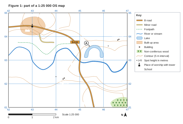
Figure 1 is part of a 1:25 000 Ordnance Survey (OS) map showing the valley of the River Wend.
Identify the landform at A.
Model answer
An ox-bow lake.
Explanation
The lake at A is horseshoe-shaped, lies on the flat flood plain right beside the meandering River Wend and has no river flowing through it - the shape of an old meander loop that has been cut off. Just writing 'lake' does not identify the landform.
Mark scheme
1 mark
Ox-bow lake
Accept oxbow lake / cut-off meander (loop) / horseshoe lake / mortlake. Do not accept 'lake', 'pond' or 'meander' on their own.
Question 2
2 marks
Define the term 'estuary'.
Model answer
An estuary is the mouth of a river where it meets the sea. It is tidal, so fresh river water mixes with salt sea water as the tide comes in and goes out.
Explanation
The key ideas are location (the river mouth, meeting the sea) and the influence of the tide. 'Where a river meets the sea' on its own earns only one mark; the second mark needs the tidal or fresh-and-salt-water idea, or its funnel shape.
Mark scheme
1 mark
The mouth of a river, where it meets the sea
1 mark
which is tidal (the water rises and falls with the tides) / where fresh river water mixes with salt sea water / which widens into a funnel shape towards the sea
Development of the first point.
Question 3
4 marks
Explain how a flood plain is formed.
Model answer
A flood plain is formed by both erosion and deposition. Meanders erode laterally on the outside of their bends, and over time they migrate across the valley and downstream. This widens the valley floor and wears away any interlocking spurs, while sediment is deposited on the inside of the bends as the meanders move. When the river floods, water spreads out over this wide valley floor, slows down and loses energy, so it deposits fine silt called alluvium. After many floods, layers of alluvium build up, creating a wide, flat and fertile flood plain.
Explanation
Many students mention only flooding and deposition, but the flood plain also needs lateral erosion by migrating meanders to widen the valley floor in the first place. Linking both processes together is what reaches Level 2.
Mark scheme
4 marks
Levels of response (4 marks). Level 2 (3-4 marks): clear explanation showing that both erosion (lateral erosion by migrating meanders widening the valley floor) and deposition (alluvium deposited during floods) form the flood plain; points are linked and developed; accurate terminology. Level 1 (1-2 marks): basic explanation with simple, unlinked points, e.g. 'the river floods and leaves silt'; may cover only erosion or only deposition. 0 marks: nothing worthy of credit.
Indicative content (not a checklist; credit other valid points): a flood plain is the wide, flat land either side of a river in its lower course; erosion: meanders erode laterally on the outside of their bends; meanders migrate across the valley and downstream, widening the valley floor and removing interlocking spurs; deposition on the inside of bends (slip-off slopes) leaves sediment behind as the meanders move; deposition: when the river floods it spreads over the land, slows down and loses energy; it deposits fine sediment (alluvium / silt); repeated flooding builds up layers of alluvium, making the flood plain flat and fertile; coarser material forms levées beside the channel.
Question 4
6 marks
For a UK river valley you have studied, describe the major landforms of erosion and deposition found along the valley.
Model answer
The River Tees rises on the slopes of Cross Fell in the North Pennines and flows east to the North Sea.
In its upper course the Tees flows in a narrow, steep-sided V-shaped valley with interlocking spurs. The most famous landform of erosion is High Force, a waterfall about 21 m high, where the river drops over a band of hard dolerite rock called the Whin Sill, which lies on top of softer limestone and shale. Below High Force is a steep-sided gorge about 700 m long, showing how far the waterfall has retreated upstream. Low Force is a smaller waterfall further downstream.
In its middle and lower course the valley becomes much wider. The river forms large meanders, with river cliffs on the outside of the bends and slip-off slopes on the inside, for example around Yarm and Stockton-on-Tees, where there are also ox-bow lakes. The river flows across a wide flood plain with levées, some of which have been raised artificially.
At its mouth the Tees forms an estuary at Teesmouth, near Middlesbrough. Here landforms of deposition dominate: wide mudflats such as Seal Sands, which are exposed at low tide, and salt marshes along their edges.
Explanation
This question rewards accurate, located detail: name the landforms and say where they are along the valley, from source to mouth. A balanced answer covers erosional landforms (waterfall, gorge, interlocking spurs) and depositional ones (flood plain, levées, estuary mudflats), with meanders and ox-bow lakes in between.
Mark scheme
6 marks
Levels of response (6 marks). Level 3 (5-6 marks): detailed description of several landforms of both erosion and deposition, located accurately along the named valley (upper, middle and lower course); detailed place-specific knowledge (named places, features or figures); accurate terminology. Level 2 (3-4 marks): clear description of some landforms of erosion and deposition with some place-specific detail; may be unbalanced, e.g. mainly erosion, or locations may be vague. Level 1 (1-2 marks): basic description of landforms with little or no place-specific detail; could apply to any river. 0 marks: nothing worthy of credit.
Indicative content (not a checklist; credit other valid points): River Tees: source on the slopes of Cross Fell in the North Pennines; upper course: narrow, steep-sided V-shaped valley with interlocking spurs; Cauldron Snout cascade; High Force waterfall, about 21 m high, where the river flows over the hard dolerite of the Whin Sill on top of softer limestone and shale; a gorge about 700 m long downstream of High Force; Low Force, a smaller waterfall further downstream; middle and lower course: the valley widens with meanders, river cliffs and slip-off slopes; large meanders and ox-bow lakes on the flood plain near Yarm and Stockton-on-Tees; wide flood plain with levées (some raised artificially); estuary at Teesmouth/Middlesbrough with mudflats (Seal Sands) and salt marsh. River Severn: source on Plynlimon in the Cambrian Mountains; V-shaped valley in the upper course; meander almost encircling Shrewsbury; wide flood plain near Tewkesbury and Gloucester; estuary with one of the largest tidal ranges in the world and extensive mudflats. Credit any appropriate named example.
Ready to try the rest? Every answer you write is marked against the mark scheme, so you can see exactly where the marks are.
Ctrl + Enter to check
AI TutorHints first, answers after you try
Hi! Stuck? Ask me for a hint and I’ll help you work it out. Once you’ve checked your answer I can explain exactly where the marks are.