Level:
Correct: 0
Incorrect: 0
Marks: 0/0
Exam Practice
Subject:
Topics:
AQA GCSE Geography (Paper 1) Smart practice A mixed round aimed at your weak spots
Unit 1
The challenge of natural hazards
Unit 2
The living world
Unit 3
Physical landscapes in the UK
Unit 4
Geographical skills: OS maps
Avg
score:
–
Topics
done:
0/32

The UK's physical landscapes

Practise 20 exam-style questions on The UK's physical landscapes for AQA GCSE Geography (Paper 1). Write your answer as you would in the exam and get it marked in seconds against the mark scheme, point by point, with an AI tutor on hand if you get stuck.

  • 20 questions
  • 1–12 marks each
  • Instant marking
  • No sign-up needed
20 questions, marked as you go

Sample questions with model answers

Here are 4 of the questions in this topic, each with a model answer, an explanation of why it earns the marks and the mark scheme an examiner would use.

Question 1

1 mark

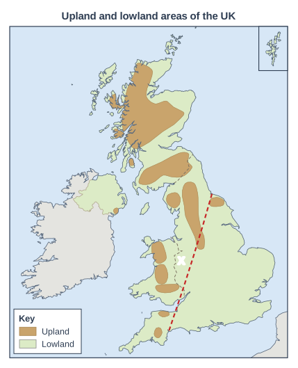
Figure 1 shows the upland and lowland areas of the UK. The dashed line labelled X divides the UK into two parts.

Name the line labelled X.

Map of the United Kingdom and Ireland, titled "Upland and lowland areas of the UK". The UK is drawn in green (lowland) with the uplands in brown. France and the Republic of Ireland are shown in grey. Dashed lines mark the borders between the countries of the UK. The Shetland Islands are shown in a separate box in the top right corner. Upland areas (brown): the Scottish Highlands (Grampian Mountains and North-West Highlands) in Scotland, the Southern Uplands in Scotland, the Lake District (Cumbrian Mountains) in England, the Pennines in England, the North York Moors in England, Snowdonia in Wales, the Cambrian Mountains in Wales, the Brecon Beacons in Wales, Dartmoor in England, Exmoor in England and the Mourne Mountains in Northern Ireland. The rest of the land is lowland (green); the uplands are mainly in the north and west of the UK and the lowlands in the south and east. Lines drawn: a dashed line labelled X, starting towards the right of the map (about 75% of the way across from the left and 50% of the way down) and ending towards the bottom of the map (about 55% of the way across from the left and 90% of the way down). The key (in a box on the map) shows: "Upland" and "Lowland".

Model answer

The Tees-Exe line.

Explanation

The Tees-Exe line runs from the mouth of the River Tees in north-east England to the mouth of the River Exe in Devon. It roughly divides upland Britain, to the north and west, from lowland Britain, to the south and east.

Mark scheme
  1. 1 mark

    The Tees-Exe line

    Accept 'Tees to Exe line' or 'line from the River Tees to the River Exe'. Do not accept 'the upland-lowland divide' without naming the line.

Question 2

2 marks

Name two rivers in the UK that flow into the North Sea.

Model answer

The River Thames and the River Tyne.

Explanation

Many of the UK's major rivers flow east to the North Sea, because the land generally slopes from the higher north and west down to the lower south and east. Rivers such as the Severn and Mersey flow west, into the Bristol Channel and the Irish Sea.

Mark scheme
  1. 1 mark

    Any one of: Thames, Tyne, Tees, Wear, Tweed, Tay, Spey, Dee (Aberdeen), Forth, Yorkshire Ouse, Trent (via the Humber), Great Ouse (via the Wash), Humber

    max 2; 1 mark for each correctly named river. Do not accept the Severn, Mersey, Clyde, Wye, Exe or Dee (Wales and Chester). Accept 'Dee' alone only if it is clear it is the Scottish Dee.

  2. 1 mark

    A second, different river from the list above

Question 3

4 marks

Explain why upland areas in the west of the UK receive more rainfall than lowland areas in the east.

Model answer

The UK's prevailing winds blow from the south-west, bringing moist air from the Atlantic Ocean. The first land this air reaches is the uplands of the west, such as the Lake District and Snowdonia. The air is forced to rise over the high ground, and as it rises it cools, so the water vapour condenses into clouds and falls as heavy relief rainfall, often more than 2000 mm a year. By the time the air has crossed the uplands and descends towards the east, it has lost much of its moisture and is warming, so few clouds form. Lowland areas in the east therefore lie in a rain shadow and receive only about 600 mm a year.

Explanation

The full chain for relief rainfall is: moist south-westerly winds → forced to rise over uplands → cooling → condensation → rain, then descent and a rain shadow in the east. Level 2 needs most of these steps linked together. Simply saying 'it is higher, so it rains more' is Level 1.

Mark scheme
  1. 4 marks

    Levels of response (4 marks).
    Level 2 (3-4 marks): clear explanation of relief rainfall, with linked points showing how prevailing winds, uplift and condensation produce high rainfall in the western uplands and a rain shadow in the east; accurate terminology.
    Level 1 (1-2 marks): basic explanation with simple, unlinked points (e.g. 'mountains get more rain').
    0 marks: nothing worthy of credit.

    Indicative content (not a checklist; credit other valid points): the prevailing winds in the UK blow from the south-west, off the Atlantic Ocean; the air has picked up moisture over the ocean; the first land it meets is the uplands in the west (e.g. the Lake District, Snowdonia, the Scottish Highlands); the air is forced to rise over the high land; as it rises it cools and the water vapour condenses to form clouds; this gives heavy relief (orographic) rainfall, often over 2000 mm a year (parts of the Lake District receive over 3000 mm); after crossing the uplands the air descends, warms and has lost much of its moisture, so the east lies in a rain shadow (often about 600 mm a year); the east is also further from the Atlantic.

Question 4

6 marks

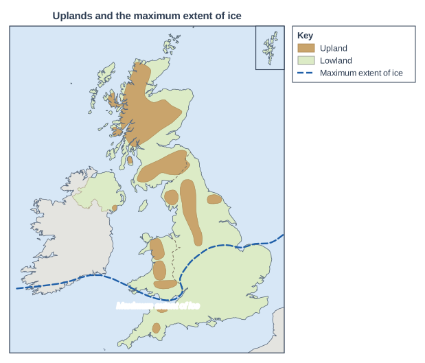
Figure 1 shows the upland areas of the UK and the maximum extent of ice in the last glacial period.

Using Figure 1 and your own knowledge, explain how glaciation has contributed to the diversity of landscapes in the UK.

Map of the United Kingdom and Ireland, titled "Uplands and the maximum extent of ice". The UK is drawn in green (lowland) with the uplands in brown. France and the Republic of Ireland are shown in grey. Dashed lines mark the borders between the countries of the UK. The Shetland Islands are shown in a separate box in the top right corner. Upland areas (brown): the Scottish Highlands (Grampian Mountains and North-West Highlands) in Scotland, the Southern Uplands in Scotland, the Lake District (Cumbrian Mountains) in England, the Pennines in England, the North York Moors in England, Snowdonia in Wales, the Cambrian Mountains in Wales, the Brecon Beacons in Wales, Dartmoor in England, Exmoor in England and the Mourne Mountains in Northern Ireland. The rest of the land is lowland (green); the uplands are mainly in the north and west of the UK and the lowlands in the south and east. A thick dashed blue line labelled "Maximum extent of ice" runs from southern Ireland across the Bristol Channel and south Wales, past the Severn estuary, across the Midlands (near Birmingham) to the Wash and the north Norfolk coast. It marks the approximate southern limit of the ice sheet at the last glacial maximum: land to the north (Scotland, northern England, most of Wales, Northern Ireland and most of Ireland) was covered by ice, while southern England was not. The key (to the right of the map) shows: "Upland", "Lowland" and "Maximum extent of ice".

Model answer

Figure 1 shows that during the last glacial period, ice covered the UK north of a line running from south Wales and the Severn estuary, across the Midlands near Birmingham, to the Wash. Scotland, northern England, most of Wales and Northern Ireland were all under ice, and almost all the upland areas were covered, except Dartmoor and Exmoor in the south-west.

In the uplands, glaciers eroded the land deeply, creating rugged landscapes that are very different from those further south. In the Lake District, Snowdonia and the Scottish Highlands there are corries, sharp arêtes and pyramidal peaks, and the valleys were widened and deepened into U-shaped troughs, often with ribbon lakes and hanging valleys. In lowland areas covered by ice, glaciers deposited thick layers of till (boulder clay), forming gently rolling landscapes such as those of Holderness, which often have fertile soils.

South of the ice limit, there was no glacial erosion. These landscapes were shaped instead by rivers and by weathering in very cold conditions near the ice, producing gentle features such as the rolling chalk downs with their dry valleys. Glaciation therefore adds to the contrast created by geology: the north and west have rugged, glaciated uplands, while the south and east have softer, gentler lowland landscapes.

Explanation

Level 3 answers use the map to say where the ice reached, then explain glacial erosion in the uplands and deposition in some lowlands, contrasting both with the unglaciated south. Named examples (the Lake District, Holderness, the chalk downs) add precision. Answers that just list glacial landforms without linking them to the diversity of UK landscapes stay in Level 2.

Mark scheme
  1. 6 marks

    Levels of response (6 marks).
    Level 3 (5-6 marks): detailed, well-developed explanation of how glacial erosion and deposition shaped landscapes north of the ice limit, contrasted with landscapes to the south; effective use of Figure 1 and accurate examples.
    Level 2 (3-4 marks): clear explanation with some development; some use of Figure 1 or examples.
    Level 1 (1-2 marks): basic statements about ice or glaciers with little explanation or use of Figure 1.
    0 marks: nothing worthy of credit.

    Indicative content (not a checklist; credit other valid points): Figure 1 shows ice covered the UK north of a line from south Wales and the Severn estuary, through the Midlands near Birmingham, to the Wash and north Norfolk; Scotland, northern England, most of Wales and Northern Ireland were covered; almost all the upland areas were under ice (except Dartmoor and Exmoor in the south-west); glacial erosion in the uplands created rugged landscapes with corries, aretes, pyramidal peaks, U-shaped valleys, hanging valleys and ribbon lakes (e.g. the Lake District, Snowdonia, the Scottish Highlands); glacial deposition left till (boulder clay), drumlins and moraines in lowland areas (e.g. Holderness, parts of East Anglia), often giving fertile farmland; south of the ice limit there was no glacial erosion - landscapes were shaped by rivers, weathering and freeze-thaw in cold (periglacial) conditions, e.g. the rolling chalk downs with dry valleys; this creates a contrast between the rugged north and west and the gentler south and east, adding to the effect of geology.

Ready to try the rest? Every answer you write is marked against the mark scheme, so you can see exactly where the marks are.

AI Tutor Hints first, answers after you try

Hi! Stuck? Ask me for a hint and I’ll help you work it out. Once you’ve checked your answer I can explain exactly where the marks are.