Level:
Correct: 0
Incorrect: 0
Marks: 0/0
Exam Practice
Subject:
Topics:
AQA GCSE Geography (Paper 1) Smart practice A mixed round aimed at your weak spots
Unit 1
The challenge of natural hazards
Unit 2
The living world
Unit 3
Physical landscapes in the UK
Unit 4
Geographical skills: OS maps
Avg
score:
–
Topics
done:
0/32

River valleys and fluvial processes

Practise 30 exam-style questions on River valleys and fluvial processes for AQA GCSE Geography (Paper 1). Write your answer as you would in the exam and get it marked in seconds against the mark scheme, point by point, with an AI tutor on hand if you get stuck.

  • 30 questions
  • 1–12 marks each
  • Instant marking
  • No sign-up needed
20 questions, marked as you go

Sample questions with model answers

Here are 4 of the questions in this topic, each with a model answer, an explanation of why it earns the marks and the mark scheme an examiner would use.

Question 1

1 mark

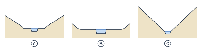
Figure 1 shows cross-sections of a river valley at three points along its course, labelled A, B and C.

Which cross-section shows the lower course of the river? Give the letter.

Diagram of cross profiles of a river valley. 3 cross-sections of a valley side by side, drawn to the same scale: the first shows a wider valley with gentler sides, with a wider strip of water and a narrow flat strip of land either side of it; the second shows a very wide valley with low, gentle sides and a wide flat floor, with a large strip of water in the middle; the third shows a narrow valley with steep sides that meet at the bottom, with a tiny strip of water in the bottom. Label A points to the caption under the first cross-section (from the left), which shows a wider valley with gentler sides, with a wider strip of water and a narrow flat strip of land either side of it; label B points to the caption under the second cross-section (from the left), which shows a very wide valley with low, gentle sides and a wide flat floor, with a large strip of water in the middle; label C points to the caption under the third cross-section (from the left), which shows a narrow valley with steep sides that meet at the bottom, with a tiny strip of water in the bottom.

Model answer

B.

Explanation

Cross-section B has a very wide, flat floor (a flood plain), low and gentle valley sides and a wide, deep channel, which are the features of the lower course. C, with steep sides meeting at the bottom and a tiny channel, is the upper course, and A, with a wider valley and a small flood plain, is the middle course.

Mark scheme
  1. 1 mark

    B

    do not accept more than one letter

Question 2

2 marks

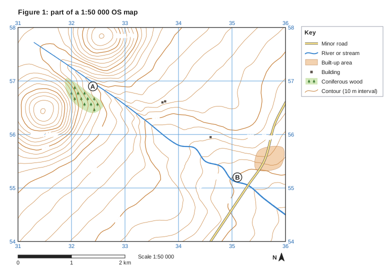
Figure 1 is part of an OS map showing the valley of the River Wend.

In which direction does the River Wend flow? Use evidence from Figure 1 to support your answer.

Figure 1: part of a 1:50 000 OS map. Ordnance Survey map extract at a scale of 1:50 000. Blue grid lines divide it into 5 by 4 squares, each 1 km across; the eastings 31, 32, 33, 34, 35, 36 are printed along the top and bottom (increasing to the east) and the northings 54, 55, 56, 57, 58 up both sides (increasing to the north). Brown contour lines show the height of the land every 10 m, with every 50 m line drawn thicker; heights printed on contour lines: 50 m, 100 m, 130 m, 150 m, 200 m. Water (blue): a river runs between the north-west of the map and the east edge. Roads and paths: a minor road runs between the south edge and the east edge. Land use: a built-up area (shaded orange) in the east of the map; 3 separate buildings (small black squares); coniferous woodland (green with tree symbols) in the north-west of the map. Names printed: "Wendford" in the east of the map; "Black Moor" in the west of the map; "Hare Fell" in the north of the map; "River Wend" in the south-east of the map. Letters in circles mark places: A in the north-west of the map; B in the south-east of the map. A key beside the map explains: minor road, river or stream, built-up area, building, coniferous wood, contour (10 m interval). Below the map: a scale bar marked 0, 1 and 2 km (1 km is the width of one grid square) and a north arrow pointing to the top of the map.

Model answer

The River Wend flows south-east. It starts in high land between Black Moor and Hare Fell, where the land is over 200 m, and flows down to land below 50 m near B, so the contour heights fall towards the south-east.

Explanation

Rivers always flow downhill, so the direction comes from the heights shown by the contours: the river runs from the 200 m contours in the north-west to below 50 m in the south-east. Where contours cross a valley they make V shapes that point upstream, which is another clue.

Mark scheme
  1. 1 mark

    South-east (from the north-west to the south-east)

    accept 'south-eastwards'; do not accept 'east' or 'south' alone

  2. 1 mark

    Evidence: the river flows from high land (Black Moor and Hare Fell, over 250 m) down to low land (below 50 m near B) / contour heights fall towards the south-east (e.g. 200 m in the north-west, 50 m near B) / the contours bend into Vs pointing upstream (north-west)

    any one valid piece of map evidence; the evidence must be consistent with the direction given

Question 3

4 marks

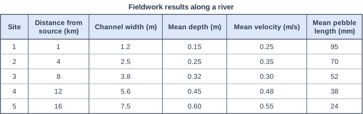
Figure 1 shows fieldwork results from five sites along a river.

Describe how the river channel and its load change downstream. Use data from Figure 1 in your answer.

Fieldwork results along a river. Table with columns "Site", "Distance from source (km)", "Channel width (m)", "Mean depth (m)", "Mean velocity (m/s)", "Mean pebble length (mm)". Site: 1; Distance from source (km): 1; Channel width (m): 1.2; Mean depth (m): 0.15; Mean velocity (m/s): 0.25; Mean pebble length (mm): 95 | Site: 2; Distance from source (km): 4; Channel width (m): 2.5; Mean depth (m): 0.25; Mean velocity (m/s): 0.35; Mean pebble length (mm): 70 | Site: 3; Distance from source (km): 8; Channel width (m): 3.8; Mean depth (m): 0.32; Mean velocity (m/s): 0.30; Mean pebble length (mm): 52 | Site: 4; Distance from source (km): 12; Channel width (m): 5.6; Mean depth (m): 0.45; Mean velocity (m/s): 0.48; Mean pebble length (mm): 38 | Site: 5; Distance from source (km): 16; Channel width (m): 7.5; Mean depth (m): 0.60; Mean velocity (m/s): 0.55; Mean pebble length (mm): 24.

Model answer

The channel gets wider and deeper downstream: its width increases from 1.2 m at Site 1 to 7.5 m at Site 5, and its mean depth from 0.15 m to 0.60 m. The mean velocity generally increases, from 0.25 m/s to 0.55 m/s, although Site 3 is an anomaly, with a velocity of 0.30 m/s, slower than Site 2. The load becomes smaller, with mean pebble length falling from 95 mm to 24 mm.

Explanation

Each trend needs data to support it, ideally the first and last values or a calculation such as 'over six times as wide'. Spotting the velocity anomaly at Site 3 shows careful reading of the table. 'Describe' does not need reasons, which would be credited in an 'explain' question.

Mark scheme
  1. 1 mark

    Channel width increases downstream, e.g. from 1.2 m at Site 1 to 7.5 m at Site 5 (over six times as wide)

    max 4; 1 mark per trend; max 2 if no data are used

  2. 1 mark

    Mean depth increases downstream, e.g. from 0.15 m to 0.60 m (four times as deep)

  3. 1 mark

    Mean velocity generally increases downstream, e.g. from 0.25 m/s to 0.55 m/s

  4. 1 mark

    Velocity is an anomaly at Site 3: 0.30 m/s, slower than Site 2 (0.35 m/s)

  5. 1 mark

    Mean pebble length decreases downstream, e.g. from 95 mm to 24 mm

Question 4

6 marks

Compare the processes operating in the upper course of a river with those operating in the lower course.

Model answer

Erosion differs between the two courses. In the upper course vertical erosion is dominant: the river is high above sea level and uses its large, angular boulders to abrade the bed, while hydraulic action attacks cracks, so the valley is deepened into a V-shape. In the lower course the river is close to sea level, so vertical erosion is limited and lateral erosion is dominant, mainly on the outside of meander bends. Attrition happens along the whole river, which is why the load is smaller and rounder in the lower course than in the upper course.

Transportation also changes. In the upper course the load is coarse, so much of it is moved by traction and saltation, and mainly during high flows after heavy rain. In the lower course the total load is greater but much finer, so most of it is carried in suspension and solution.

Deposition is limited in the upper course, where only large boulders are dropped as flood waters fall. In contrast, deposition is common in the lower course: on the inside of meander bends, across the flood plain during floods and at the river mouth.

These differences are caused by changes in energy. The upper course has a steep gradient, but much of the river's energy is lost to friction in its shallow, rocky channel. The lower course has a gentle gradient, but a greater discharge and a smoother, more efficient channel, so it can carry a large, fine load, while its closeness to sea level means it erodes sideways rather than downwards.

Explanation

'Compare' needs paired points: for each process, say how the upper course differs from the lower course, using words such as 'whereas' and 'in contrast'. Level 3 answers cover erosion, transportation and deposition and explain the differences in terms of energy, gradient and load. Two separate descriptions without linking stay in Level 1.

Mark scheme
  1. 6 marks

    Levels of response (6 marks).
    Level 3 (5-6 marks): detailed comparison of erosion, transportation and deposition in the upper and lower courses, with paired points using comparative language, and explanation of the differences in terms of energy, gradient, discharge and load; accurate use of a wide range of terminology.
    Level 2 (3-4 marks): clear comparison of some processes with some explanation; may be unbalanced or cover only erosion and transport.
    Level 1 (1-2 marks): basic statements, mostly separate descriptions of each course with little direct comparison.
    0 marks: nothing worthy of credit.

    Indicative content (not a checklist; credit other valid points): erosion: vertical erosion is dominant in the upper course, whereas lateral erosion is dominant in the lower course; abrasion by large, angular boulders and hydraulic action cut down the bed in the upper course, while in the lower course erosion is mainly on the outside of meander bends; attrition happens along the whole river, so the load becomes smaller and rounder downstream; transportation: in the upper course large material is moved by traction and saltation, mostly during high flows, whereas in the lower course the load is larger in total but finer, carried mainly in suspension and solution; deposition: little deposition in the upper course apart from boulders as floods fall, whereas there is much deposition in the lower course, on the inside of bends, on the flood plain during floods and at the mouth; energy: the upper course is high above sea level with a steep gradient but much energy is lost to friction in the shallow, rough channel, whereas the lower course has a gentle gradient but more discharge and a more efficient channel; credit reference to resulting landforms (V-shaped valley versus flood plain).

Ready to try the rest? Every answer you write is marked against the mark scheme, so you can see exactly where the marks are.

AI Tutor Hints first, answers after you try

Hi! Stuck? Ask me for a hint and I’ll help you work it out. Once you’ve checked your answer I can explain exactly where the marks are.