Practise 34 exam-style questions on Coastal landforms for AQA GCSE Geography (Paper 1). Write your answer as you would in the exam and get it marked in seconds against the mark scheme, point by point, with an AI tutor on hand if you get stuck.
34 questions
1–12 marks each
Instant marking
No sign-up needed
20 questions, marked as you go
Sample questions with model answers
Here are 4 of the questions in this topic, each with a model answer, an explanation of why it earns the marks and the mark scheme an examiner would use.
Question 1
1 mark
State the name given to a damp hollow between sand dunes, where the water table is at or near the surface.
Model answer
A dune slack.
Explanation
Dune slacks are low-lying hollows within a dune system where the water table reaches or nearly reaches the surface, so they are often damp or flooded in winter. They support wetland plants such as reeds and rushes, unlike the dry dunes around them.
Mark scheme
1 mark
Dune slack
accept 'slack'
Question 2
2 marks
For a section of UK coastline you have studied, name one landform of erosion and one landform of deposition found there.
Model answer
On the Dorset coast near Swanage, Old Harry Rocks are stacks, a landform of erosion, and Studland Bay has a sandy beach and sand dunes, landforms of deposition.
Explanation
The specification asks you to know a section of UK coastline well enough to identify its major landforms of erosion and deposition. The marks need real, accurate landforms for the coastline you name - for Holderness, for example, the chalk caves and stacks of Flamborough Head (erosion) and Spurn Head spit (deposition).
Mark scheme
1 mark
A correctly named landform of erosion on the chosen coastline, e.g. Old Harry Rocks (stacks), Durdle Door (arch), Lulworth Cove (cove), Flamborough Head (headland with caves, arches and stacks)
the landform must be accurate for the coastline named; accept a landform type with its location, e.g. 'chalk stacks at Handfast Point'; credit any appropriate named example
1 mark
A correctly named landform of deposition on the chosen coastline, e.g. Studland Bay beach and sand dunes, Spurn Head (spit), Chesil Beach, Hurst Castle spit
Question 3
4 marks
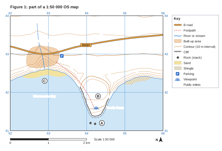
Figure 1 is part of an OS map of a stretch of coast.
Use evidence from Figure 1 to show that this stretch of coast has landforms of both erosion and deposition.
Model answer
Erosion: there are cliffs around the headland of Kestle Down, from about 638421 to 646417, and two stacks just offshore at 641412 and 642411. The headland itself juts out about 1 km into the sea at B.
Deposition: there is a sandy beach in Westcombe Bay, from about 623424 to 634424, and a shingle beach east of the headland, from about 649422 to 657423.
Explanation
'Use evidence from the map' means naming a landform and locating it with a grid reference, a name or a letter. The cliff symbol and the rock (stack) symbol show erosion; the sand and shingle symbols show deposition. Listing landforms without saying where they are on the map does not count as evidence.
Mark scheme
1 mark
Cliffs around Kestle Down / from about 638421 to 646417 (landform of erosion)
max 4; 1 mark for each landform correctly identified with map evidence (a grid reference, place name or letter); max 3 if only landforms of erosion or only landforms of deposition are given; accept 6-figure references within one in the third and sixth figures, or correct 4-figure squares
1 mark
Stacks just offshore at 641412 and 642411, near A (landform of erosion)
accept square 6441
1 mark
A headland (Kestle Down, at B) jutting about 1 km south into the sea (landform of erosion)
1 mark
A bay (Westcombe Bay, at C / square 6242) (landform of erosion)
1 mark
A sand beach in Westcombe Bay, from about 623424 to 634424 (landform of deposition)
accept squares 6242 / 6342
1 mark
A shingle beach east of the headland, from about 649422 to 657423 (landform of deposition)
accept square 6542
Question 4
6 marks
Using a named example of a section of UK coastline, identify and describe its major landforms of erosion and deposition.
Model answer
The Dorset coast around Swanage has a wide range of landforms. Between Studland and Durlston Head it is a discordant coastline, with bands of hard and soft rock meeting the sea at right angles.
Landforms of erosion: Swanage Bay has been eroded into soft sands and clays, between two headlands of more resistant rock. To the north is Handfast Point, a chalk headland with steep white cliffs, caves and arches. Just off its tip is Old Harry, a tall chalk stack, with the low stump of Old Harry's Wife beside it. To the south of the bay are the limestone headlands of Peveril Point and Durlston Head. Further west, the coast is concordant: at Lulworth Cove the sea has broken through a narrow gap in the limestone and eroded a rounded cove in the softer rocks behind, and nearby Durdle Door is a limestone arch.
Landforms of deposition: Swanage Bay itself has a sandy beach, sheltered by the headlands. North of Handfast Point, Studland Bay has a wide, gently sloping sandy beach backed by a large sand dune system, with embryo dunes near the sea and older, vegetated dunes and heathland further inland. Further west still is Chesil Beach, a shingle beach about 29 km long with the Fleet lagoon behind it.
Explanation
'Identify and describe' means naming each landform, saying where it is and what it is like. Level 3 needs several accurately located landforms of both erosion and deposition from one coastline. A list of generic landforms ('there are stacks and beaches') with no place names is Level 1.
Mark scheme
6 marks
Levels of response (6 marks). Level 3 (5-6 marks): detailed description of several landforms of both erosion and deposition, accurately located on the named coastline; detailed place-specific knowledge; accurate use of a wide range of terminology. Level 2 (3-4 marks): clear description of some landforms with some place-specific detail; may be unbalanced, e.g. mostly erosion or mostly deposition. Level 1 (1-2 marks): basic description, simple statements naming landforms with little or no location or detail; generic, not place-specific. 0 marks: nothing worthy of credit.
Indicative content (not a checklist; credit other valid points): Dorset coast around Swanage: discordant coast; Swanage Bay in soft sands and clays between headlands of resistant rock; Handfast Point (chalk) with caves, arches, the stack Old Harry and the stump Old Harry's Wife; Peveril Point and Durlston Head (limestone headlands); Studland Bay to the north with a wide sandy beach and sand dunes showing succession and a lagoon (Little Sea) behind; further west on the concordant coast, Lulworth Cove (rounded cove behind a narrow entrance in limestone), Stair Hole (an early-stage cove) and Durdle Door (limestone arch); Chesil Beach, a shingle barrier beach about 29 km long with the Fleet lagoon behind it. Holderness coast: about 60 km of boulder clay cliffs between Flamborough Head and Spurn Head, retreating rapidly with slumping; Flamborough Head, a chalk headland with caves, arches and stacks; beaches at resorts such as Hornsea and Withernsea; Spurn Head, a spit about 5 km long with a recurved end and salt marsh behind it in the Humber estuary; credit any appropriate named example.
Ready to try the rest? Every answer you write is marked against the mark scheme, so you can see exactly where the marks are.
Ctrl + Enter to check
AI TutorHints first, answers after you try
Hi! Stuck? Ask me for a hint and I’ll help you work it out. Once you’ve checked your answer I can explain exactly where the marks are.