Level:
Correct: 0
Incorrect: 0
Marks: 0/0
Exam Practice
Subject:
Topics:
AQA GCSE Geography (Paper 1) Smart practice A mixed round aimed at your weak spots
Unit 1
The challenge of natural hazards
Unit 2
The living world
Unit 3
Physical landscapes in the UK
Unit 4
Geographical skills: OS maps
Avg
score:
–
Topics
done:
0/32

OS maps: relief, contours, gradient and landscape features

Practise 30 exam-style questions on OS maps: relief, contours, gradient and landscape features for AQA GCSE Geography (Paper 1). Write your answer as you would in the exam and get it marked in seconds against the mark scheme, point by point, with an AI tutor on hand if you get stuck.

  • 30 questions
  • 1–6 marks each
  • Instant marking
  • No sign-up needed
20 questions, marked as you go

Sample questions with model answers

Here are 4 of the questions in this topic, each with a model answer, an explanation of why it earns the marks and the mark scheme an examiner would use.

Question 1

1 mark

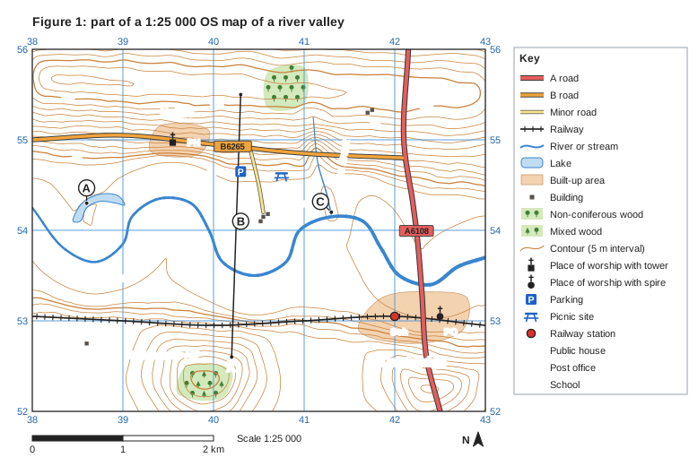
Study Figure 1, part of a 1:25 000 OS map of a river valley.

Name the river landform at A.

Figure 1: part of a 1:25 000 OS map of a river valley. Ordnance Survey map extract at a scale of 1:25 000. Blue grid lines divide it into 5 by 4 squares, each 1 km across; the eastings 38, 39, 40, 41, 42, 43 are printed along the top and bottom (increasing to the east) and the northings 52, 53, 54, 55, 56 up both sides (increasing to the north). Brown contour lines show the height of the land every 5 m, with every 50 m line drawn thicker; heights printed on contour lines: 40 m, 50 m, 90 m, 100 m. Water (blue): a river runs between the west edge and the east edge; a stream runs between the north of the map and the centre of the map; a lake in the west of the map. Roads and paths: the A6108 (A road) runs between the north edge and the south edge; the B6265 (B road) runs between the west edge and the north-east of the map; a minor road runs between the north of the map and the centre of the map; a railway runs between the west edge and the east edge. Land use: a built-up area (shaded orange) in the south-east of the map; a built-up area (shaded orange) in the north-west of the map; 6 separate buildings (small black squares); non-coniferous woodland (green with tree symbols) in the north of the map; mixed woodland (green with tree symbols) in the south of the map. Symbols: railway station in the south-east of the map; place of worship with spire in the south-east of the map; "Sch" (school) in the south-east of the map; "PO" (post office) in the south-east of the map; place of worship with tower in the north-west of the map; "PH" (public house) in the north of the map; picnic site in the centre of the map; parking in the centre of the map. Names printed: "Tarnbridge" in the south-east of the map; "Holme" in the north-west of the map; "River Tarne" in the west of the map; "Moss Brook" in the north-east of the map; "Coldharbour Hill" in the south-west of the map; "Ings Fm" in the centre of the map; "Ridge Fm" in the north-east of the map. Letters in circles mark places: A in the west of the map (a dot marks the exact place); B in the centre of the map; C in the centre of the map (a dot marks the exact place). A straight line X–Y is drawn from X in the south of the map to Y in the north of the map. A key beside the map explains: A road, B road, minor road, railway, river or stream, lake, built-up area, building, non-coniferous wood, mixed wood, contour (5 m interval), place of worship with tower, place of worship with spire, parking, picnic site, railway station, PH = public house, PO = post office, Sch = school. Below the map: a scale bar marked 0, 1 and 2 km (1 km is the width of one grid square) and a north arrow pointing to the top of the map.

Model answer

An ox-bow lake.

Explanation

A is a crescent-shaped lake on the flat flood plain beside the meandering River Tarne, but it is not connected to the river. This horseshoe shape shows a former meander that has been cut off from the main channel.

Mark scheme
  1. 1 mark

    Ox-bow lake

    accept 'oxbow lake' or 'cut-off meander'; do not accept 'lake' or 'meander' on its own

Question 2

2 marks

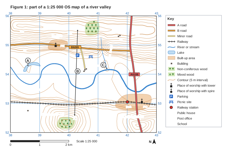
Study Figure 1, part of a 1:25 000 OS map of a river valley.

Describe the shape of the land along the line from X to Y.

Figure 1: part of a 1:25 000 OS map of a river valley. Ordnance Survey map extract at a scale of 1:25 000. Blue grid lines divide it into 5 by 4 squares, each 1 km across; the eastings 38, 39, 40, 41, 42, 43 are printed along the top and bottom (increasing to the east) and the northings 52, 53, 54, 55, 56 up both sides (increasing to the north). Brown contour lines show the height of the land every 5 m, with every 50 m line drawn thicker; heights printed on contour lines: 40 m, 50 m, 90 m, 100 m. Water (blue): a river runs between the west edge and the east edge; a stream runs between the north of the map and the centre of the map; a lake in the west of the map. Roads and paths: the A6108 (A road) runs between the north edge and the south edge; the B6265 (B road) runs between the west edge and the north-east of the map; a minor road runs between the north of the map and the centre of the map; a railway runs between the west edge and the east edge. Land use: a built-up area (shaded orange) in the south-east of the map; a built-up area (shaded orange) in the north-west of the map; 6 separate buildings (small black squares); non-coniferous woodland (green with tree symbols) in the north of the map; mixed woodland (green with tree symbols) in the south of the map. Symbols: railway station in the south-east of the map; place of worship with spire in the south-east of the map; "Sch" (school) in the south-east of the map; "PO" (post office) in the south-east of the map; place of worship with tower in the north-west of the map; "PH" (public house) in the north of the map; picnic site in the centre of the map; parking in the centre of the map. Names printed: "Tarnbridge" in the south-east of the map; "Holme" in the north-west of the map; "River Tarne" in the west of the map; "Moss Brook" in the north-east of the map; "Coldharbour Hill" in the south-west of the map; "Ings Fm" in the centre of the map; "Ridge Fm" in the north-east of the map. Letters in circles mark places: A in the west of the map (a dot marks the exact place); B in the centre of the map; C in the centre of the map (a dot marks the exact place). A straight line X–Y is drawn from X in the south of the map to Y in the north of the map. A key beside the map explains: A road, B road, minor road, railway, river or stream, lake, built-up area, building, non-coniferous wood, mixed wood, contour (5 m interval), place of worship with tower, place of worship with spire, parking, picnic site, railway station, PH = public house, PO = post office, Sch = school. Below the map: a scale bar marked 0, 1 and 2 km (1 km is the width of one grid square) and a north arrow pointing to the top of the map.

Model answer

From X at about 88 m the land slopes down gently to a wide, flat valley floor at about 37 m, which is about 1.4 km wide and is crossed by the River Tarne. It then rises gently up the northern valley side to about 106 m at Y, so the cross-section is a wide, shallow valley with a flat floor.

Explanation

Where contours are absent the land is flat: here a broad flood plain. Strong answers describe the shape (flat floor, gentle sides) and support it with heights and distances read from the contours.

Mark scheme
  1. 1 mark

    A wide, flat valley floor (flood plain) about 1.4 km wide at about 37-42 m, crossed by the River Tarne

    max 2; 1 mark for each accurate descriptive point; credit use of heights and distances

  2. 1 mark

    Gently sloping valley sides rising to about 88 m at X and about 106 m at Y

    credit 'gentle slopes' with any evidence, e.g. steepest about 1 in 10

  3. 1 mark

    The overall shape is a wide, shallow, flat-floored valley; the northern side (towards Y) rises higher than the southern side (towards X)

Question 3

3 marks

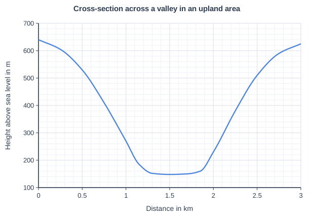
Figure 1 is a cross-section drawn across a valley in an upland area of the UK.

Identify the type of valley shown. Use evidence from Figure 1 to support your answer.

Cross-section across a valley in an upland area. Line graph of height above sea level in m (y-axis, 100 to 700) against distance in km (x-axis, 0 to 3). The line is a smooth curve through (0, 640), (0.25, 605), (0.5, 530), (0.75, 410), (1, 270), (1.15, 185), (1.3, 152), (1.5, 148), (1.7, 150), (1.85, 160), (2, 230), (2.25, 380), (2.5, 510), (2.75, 590), (3, 625).

Model answer

It is a glacial trough (a U-shaped valley). It has a wide, flat floor about 0.5 km across at about 150 m, and very steep sides: on the left the land falls from about 530 m to about 185 m in only about 0.65 km. The valley is nearly 500 m deep, from about 640 m at the top down to about 148 m on the floor.

Explanation

The shape of a cross-section tells you which process formed the valley: a flat floor with steep sides is the U-shape left by a glacier, whereas a river valley in the uplands is a narrow V. Quoting heights and distances from the graph gives the evidence.

Mark scheme
  1. 1 mark

    A glacial trough / U-shaped valley

    accept 'a valley eroded by a glacier'; do not accept 'V-shaped valley' or 'river valley'

  2. 1 mark

    Evidence: a wide, flat valley floor, about 0.5-0.6 km wide (from about 1.3 km to 1.85 km), at about 150 m

    max 2 for evidence; credit evidence with data even if the valley type is wrong

  3. 1 mark

    Evidence: very steep valley sides, e.g. falling about 345 m (from about 530 m to 185 m) in about 0.65 km on the left-hand side

  4. 1 mark

    Evidence: a deep valley, nearly 500 m deep (from about 640 m and 625 m at the edges down to about 148 m)

Question 4

4 marks

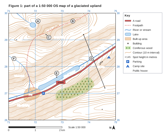
Study Figure 1, part of a 1:50 000 OS map of a glaciated upland.

Using map evidence, describe the drainage of the area shown.

Figure 1: part of a 1:50 000 OS map of a glaciated upland. Ordnance Survey map extract at a scale of 1:50 000. Blue grid lines divide it into 4 by 4 squares, each 1 km across; the eastings 71, 72, 73, 74, 75 are printed along the top and bottom (increasing to the east) and the northings 26, 27, 28, 29, 30 up both sides (increasing to the north). Brown contour lines show the height of the land every 10 m, with every 50 m line drawn thicker; heights printed on contour lines: 140 m, 150 m, 350 m, 370 m, 380 m, 420 m. Spot heights (a dot with the height in metres): 432 in the south-east of the map; 454 in the north-west of the map. Water (blue): a river runs between the east edge and the centre of the map; a river runs between the south-west of the map and the west edge; a stream runs between the north-west of the map and the north edge; a stream runs between the west edge and the south-west of the map; a lake in the centre of the map; a lake in the north-west of the map. Roads and paths: the A5091 (A road) runs between the east edge and the west edge; 2 footpaths (red dashed lines). Land use: a built-up area (shaded orange) in the south-west of the map; 3 separate buildings (small black squares); coniferous woodland (green with tree symbols) in the south of the map. Symbols: "PH" (public house) in the south-west of the map; parking in the south-west of the map; camp site in the east of the map. Names printed: "Grey Pike" in the north of the map; "Skell Water" in the centre of the map; "Skellside" in the south-west of the map; "Waterfall" in the west of the map; "Gill Fm" in the east of the map; "Skelldale" in the north-east of the map. Letters in circles mark places: A in the north-west of the map; B in the north of the map; C in the north of the map (a dot marks the exact place); D in the east of the map; E in the centre of the map (a dot marks the exact place); F in the west of the map. A straight line X–Y is drawn from X in the south-east of the map to Y in the north-east of the map. A key beside the map explains: A road, footpath, river or stream, lake, built-up area, building, coniferous wood, contour (10 m interval), spot height in metres, parking, camp site, PH = public house. Below the map: a scale bar marked 0, 1 and 2 km (1 km is the width of one grid square) and a north arrow pointing to the top of the map.

Model answer

The main river, Skell Beck, enters the map at the east edge and flows south-west along the floor of Skelldale into Skell Water, a ribbon lake about 1.5 km long with its surface at about 133 m. It flows out of the western end of the lake and off the west edge of the map. Raise Gill flows south-east from a hanging valley, drops over a waterfall at about 714276 and joins Skell Beck at about 717270. In the north-west, Blea Beck drains Blea Tarn, a small corrie lake at about 383 m, and flows north-west off the map. The streams are fairly straight, and the high ridge of Grey Pike has no streams on it.

Explanation

Drainage means the rivers, streams and lakes and how they are arranged. Describe where each river flows, its direction, the lakes it passes through and where tributaries join, using grid references; in a glaciated area the lakes (tarns, ribbon lakes) and waterfalls from hanging valleys are distinctive.

Mark scheme
  1. 1 mark

    Skell Beck, the main river, enters at the east edge (about 750288) and flows south-west along the floor of Skelldale

    max 4; 1 mark for each accurate descriptive point using map evidence

  2. 1 mark

    Skell Beck flows into and out of a long ribbon lake, Skell Water (about 1.5 km long, surface about 133 m), then leaves the map at the west edge (about 710268)

  3. 1 mark

    Raise Gill enters from the west edge, flows south-east through the hanging valley, drops by a waterfall (about 714276) and joins Skell Beck at a confluence at about 717270

    credit the steep fall of Raise Gill (about 220 m in 1.7 km)

  4. 1 mark

    Blea Beck drains Blea Tarn, a small corrie lake at about 383 m (719295), and flows north-west off the north edge

  5. 1 mark

    The streams have fairly straight courses with no meanders, and there are few streams on the high ridges and peak, which act as a watershed

    credit other accurate points

Ready to try the rest? Every answer you write is marked against the mark scheme, so you can see exactly where the marks are.

AI Tutor Hints first, answers after you try

Hi! Stuck? Ask me for a hint and I’ll help you work it out. Once you’ve checked your answer I can explain exactly where the marks are.