
Level:
Correct: 0
Incorrect: 0
Marks: 0/0
Exam Practice
Course:
Topics:
Avg
score:
–
Topics
done:
0/20

Threats to the taiga

Practise 27 exam-style questions on Threats to the taiga for Edexcel GCSE Geography B (Paper 3). Write your answer as you would in the exam and get it marked in seconds against the mark scheme, point by point, with the Study Helper on hand if you get stuck.

  • 27 questions
  • 1–8 marks each
  • Instant marking
  • No sign-up needed
20 questions, marked as you go

Sample questions with model answers

Here are 4 of the questions in this topic, each with a model answer, an explanation of why it earns the marks and the mark scheme an examiner would use.

Question 1

1 mark

Study Figure 1, which shows the pH of rainfall measured at sites around a nickel smelter in an imaginary area of taiga. The map was written for this course. The lower the pH, the more acidic the rain.

Calculate the range of the pH values measured at the sites shown in Figure 1.
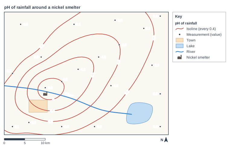
pH of rainfall around a nickel smelter. Map of a local area, 40 km from west to east and 30 km from south to north, with north at the top. Areas: the town shown pale orange, in the south-west of the map; the lake shown blue, in the south-east of the map. Lines: River (a river, blue, named) runs from the west edge to the south-east of the map, passing through the south of the map. Symbols: the nickel smelter in the west of the map (580 m from River). Isoline map of pH of rainfall: red isolines join places with equal values, drawn every 0.4 and labelled 4, 4.4, 4.8 and 5.2. The 4 isoline is a closed loop in the west of the map (the value 3.8 is inside it); the 4.4 isoline is a closed loop in the centre of the map (the values 3.8, 4.0 and 4.2 are inside it); the 4.8 isoline is a closed loop in the centre of the map, enclosing the town (the values 3.8, 4.0, 4.2 and 4.5 are inside it); the 5.2 isoline is a line from the north edge to the west edge, passing through the north, north-west and west of the map, a line from the north edge to the south edge, passing through the north-east, east, south-east and south of the map and a line from the west edge to the south edge, passing through the south-west of the map. Measured values printed beside dots: 3.8 in the west of the map; 4.0 in the centre of the map; 4.2 in the centre of the map; 4.5 in the centre of the map; 4.8 in the north-east of the map; 5.1 in the north-east of the map; 5.3 in the north-east of the map; 5.0 in the south-west of the map; 5.1 in the south-west of the map; 5.2 in the west of the map; 5.0 in the south of the map; 5.3 in the south of the map; 5.5 in the east of the map; 5.3 in the east of the map; 5.5 in the north-west of the map; 5.1 in the north of the map; 4.9 in the centre of the map; 5.0 in the west of the map; 5.6 in the south-east of the map; 5.0 in the north-east of the map. The key (beside the map) shows: [pH of rainfall], isoline (every 0.4), measurement (value), town, lake, river, nickel smelter. Below the map: a scale bar marked 0, 5 and 10 km and a north arrow pointing to the top.

Model answer

5.6 − 3.8 = 1.8

Explanation

The range is the highest value minus the lowest value. The most acidic rain (pH 3.8) falls beside the smelter and the least acidic (pH 5.6) falls in the far south-east of the map. Each fall of 1 on the pH scale means the rain is ten times more acidic, so a range of 1.8 is a very large difference.

Mark scheme
  1. 1 mark

    1.8 (5.6 − 3.8)

    Correct answer with no working scores the mark. The highest value measured is 5.6 (in the south-east of the map) and the lowest is 3.8 (beside the smelter). Do not credit '3.8 to 5.6' (the lowest and highest values, not the range) or an answer that uses isoline values instead of the measured values (e.g. 5.2 − 4.0 = 1.2).
Question 2

2 marks

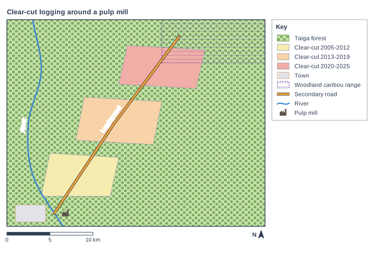
Study Figure 1, which shows the areas of taiga that have been clear-cut (clear-felled) to supply a pulp mill. The map shows an imaginary area and was written for this course.

Using your own knowledge, explain one reason why the taiga is often logged by clear-felling rather than by cutting only selected trees.

Clear-cut logging around a pulp mill. Map of a local area, 30 km from west to east and 24 km from south to north, with north at the top. Areas: the taiga forest shown green with tree symbols, covering the whole map; the clear-cut 2005-2012 shown yellow, in the south-west of the map; the clear-cut 2013-2019 shown orange, in the centre of the map; the clear-cut 2020-2025 shown red, in the north of the map; the woodland caribou range shown purple hatching with a dotted purple outline, in the north-east of the map; the town shown grey, in the south-west of the map. Lines: River (a river, blue, named) runs from the north edge to the south edge, passing through the west of the map; Logging road (secondary road) runs from the south-west of the map to the north of the map, passing through the centre of the map. Symbols: the pulp mill in the south-west of the map (inside the taiga forest; 1 km from River; beside Logging road (secondary road)). The key (beside the map) shows: taiga forest, clear-cut 2005-2012, clear-cut 2013-2019, clear-cut 2020-2025, town, woodland caribou range, secondary road, river, pulp mill. Below the map: a scale bar marked 0, 5 and 10 km and a north arrow pointing to the top.

Model answer

The taiga is made up of large stands of only a few species of conifer, such as spruce and pine, which are all useful for timber or pulp. This means it is cheapest to cut every tree in an area with large machines, rather than searching for a few valuable trees.

Explanation

One mark is for the reason and one for explaining why it makes clear-felling worthwhile. Unlike a tropical rainforest, where only a few trees in each hectare are valuable, the taiga has large stands of a few useful conifer species. Answers that describe the damage clear-felling causes do not answer the question.

Mark scheme
  1. 1 mark

    Identifies a valid reason, e.g. the forest is made up of a few species of conifer that are all useful / trees are of similar size and value / large machines can cut whole areas cheaply / pulp mills need very large volumes of wood

    Examples: The taiga is made up of large stands of only a few species of conifer (1) which are all useful for timber or pulp, so it is efficient to cut every tree rather than search for valuable ones (1). Large harvesting machines can fell and process whole areas quickly (1) which keeps the cost per tree low (1). Pulp mills need huge, steady volumes of wood (1) and clear-felling supplies this most cheaply (1). Accept any other appropriate response.

  2. 1 mark

    Develops the reason, e.g. so it is efficient to cut every tree / so costs are kept low

    Do not credit 'it is quicker' or 'it is easier' on its own. Do not credit the effects of clear-felling: the question asks why it is used.

Question 3

2 marks

Using your own knowledge, explain one way in which burning fossil fuels in places far from the taiga can still threaten it.

Model answer

Burning fossil fuels anywhere in the world releases carbon dioxide, which adds to climate change. As a result the taiga is getting hotter, drier summers and milder winters, which bring larger forest fires and allow more pests, such as bark beetles, to survive the winter.

Explanation

One mark is for identifying how pollution from burning fossil fuels reaches the taiga (climate change or long-distance acid rain) and one for explaining the damage it causes. This is an indirect threat: the forest is harmed even though no trees are cut down.

Mark scheme
  1. 1 mark

    Identifies a way, e.g. carbon dioxide adds to climate change / sulphur dioxide and nitrogen oxides from power stations are carried long distances by the wind and fall as acid rain

    Examples: Burning fossil fuels anywhere releases carbon dioxide, which adds to climate change (1) so the taiga gets hotter, drier summers and milder winters, bringing larger forest fires and more pest outbreaks (1). Sulphur dioxide and nitrogen oxides from power stations and factories are carried hundreds of kilometres by the wind (1) and fall as acid rain, which damaged forests and lakes in Scandinavia, far from where the coal was burned (1). Warming caused by fossil fuels thaws permafrost (1) so the ground subsides and trees tilt or die (1). Accept any other appropriate response.

  2. 1 mark

    Develops the way, e.g. more fires and pest outbreaks / acid rain damages trees, soils and lakes far downwind

    Do not credit effects of extracting fossil fuels in the taiga itself (e.g. oil sands mines): the question is about burning them elsewhere.

Question 4

4 marks

In parts of the taiga, such as West Siberia in Russia and northern Alberta in Canada, oil and gas are produced from thousands of wells linked by pipelines and processing plants.

Using your own knowledge, explain two ways in which pollution from oil and gas production can threaten the taiga.

Model answer

One way is through oil spills. Old wells and pipelines can leak, and the oil soaks into the soil, peat bogs and rivers. Because it is cold for much of the year, the oil breaks down very slowly, so it kills plants, fish and birds and keeps polluting the area for many years.

A second way is acid rain. Gas-processing plants and the flares at oil wells release sulphur dioxide and nitrogen oxides. These dissolve in rain and fall as acid rain, which damages conifer needles and the lichens that caribou eat, and makes lakes and streams more acidic.

Explanation

Each way needs a source of pollution (1) and an explanation of how it harms the forest, its soils, water or wildlife (1). Clearing land for wells and pipelines is not pollution, so it does not answer this question. Strong answers explain why pollution lasts a long time in the cold taiga.

Mark scheme
  1. 1 mark

    First way, e.g. oil leaks or spills from wells and pipelines / acid gases (sulphur dioxide, nitrogen oxides) from processing plants and gas flares / salty waste water spilled from pipelines / toxic waste leaking from tailings ponds / methane leaks and gas flaring adding to climate change

    In each case, award 1 mark for a way and 1 mark for further explanation, up to 4 marks. The two ways must be different. Examples: Oil leaks from old wells and pipelines (1) and soaks into soils, peat bogs and rivers, where it breaks down very slowly in the cold, killing plants, fish and birds for many years (1). Processing plants and gas flares release sulphur dioxide and nitrogen oxides (1) which fall as acid rain, damaging conifer needles and lichens and acidifying lakes (1). Very salty water pumped up with the oil can spill from pipelines (1) and the salt kills trees and other plants, leaving ground where forest cannot regrow for years (1). Waste from oil sands processing is stored in tailings ponds (1) which can leak toxic chemicals into rivers and kill birds that land on them (1). Methane leaks and gas flaring release greenhouse gases (1) which add to climate change, bringing larger fires and more pest outbreaks to the taiga (1). Accept any other appropriate response.

  2. 1 mark

    Explains the first way

  3. 1 mark

    Second way, different from the first

    Do not credit clearing forest for wells, roads or pipelines: this is not pollution. Do not credit two ways that are the same idea in different words (e.g. two different oil spills).

  4. 1 mark

    Explains the second way

Ready to try the rest? Every answer you write is marked against the mark scheme, so you can see exactly where the marks are.

Study Helper Hints first, answers after you try

Stuck on this one? Ask for a hint and I’ll point you in the right direction, without giving the answer away. Once you’ve checked your answer, I’ll show you how the marks are awarded.