Level:
Correct: 0
Incorrect: 0
Marks: 0/0
Exam Practice
Course:
Topics:
Avg
score:
–
Topics
done:
0/20

Decision-making: mines, wind and reindeer in Lapland

Practise 25 exam-style questions on Decision-making: mines, wind and reindeer in Lapland for Edexcel GCSE Geography B (Paper 3). Write your answer as you would in the exam and get it marked in seconds against the mark scheme, point by point, with the Study Helper on hand if you get stuck.

  • 25 questions
  • 1–16 marks each
  • Instant marking
  • No sign-up needed
20 questions, marked as you go

Sample questions with model answers

Here are 4 of the questions in this topic, each with a model answer, an explanation of why it earns the marks and the mark scheme an examiner would use.

Question 1

1 mark

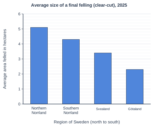
Figure 1 is a bar chart from a resource booklet (written for this course using data from the Swedish Forest Agency). It shows the average size of a final felling (a clear-cut, where all or nearly all the trees in an area are cut down) in four regions of Sweden in 2025. Northern Norrland includes Norrbotten.

Study Figure 1.

Calculate how many times larger the average final felling was in Northern Norrland than in Götaland.

Average size of a final felling (clear-cut), 2025. Bar chart of average area felled in hectares for each Region of Sweden (north to south): Northern Norrland 5.1, Southern Norrland 4.3, Svealand 3.4, Götaland 2.3.

Model answer

5.1 ÷ 2.3 = 2.217... = 2.2 times larger

Explanation

Divide the larger value by the smaller value to find how many times larger it is. A common error is to subtract (5.1 - 2.3 = 2.8 hectares), which gives the difference, not how many times larger.

Mark scheme
  1. 1 mark

    2.2 (times larger); accept answers from 2.1 to 2.4 worked from readings within the accepted ranges

    5.1 ÷ 2.3 = 2.217... Correct answer with no working scores the mark. Accept readings from 5.0 to 5.2 hectares (Northern Norrland) and from 2.2 to 2.4 hectares (Götaland), half a minor gridline either side of the bar heights. Award the mark for the answer worked correctly from the student's own readings within these ranges, given to at least two significant figures and correctly rounded: answers from 2.08 to 2.36 (2.1 to 2.4 to two significant figures), e.g. 2.2, 2.22 or 2.217 from 5.1 and 2.3. Do not credit a one-significant-figure answer such as 2. Do not accept 2.8 (the difference in hectares) or 0.5 (the ratio the wrong way round, 2.3 ÷ 5.1).

Question 2

2 marks

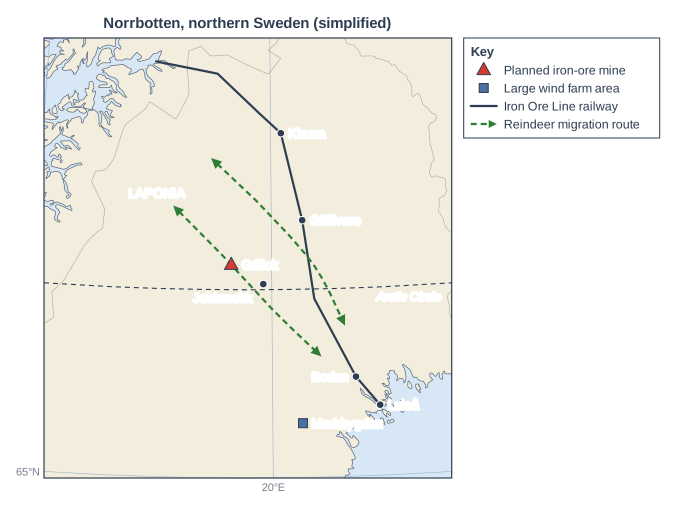
Figure 1 is a map from a resource booklet about land use in Norrbotten, the northernmost county of Sweden. The booklet was written for this course, and the reindeer migration routes on the map are simplified.

Sami reindeer herders move their herds between summer pastures in the mountains in the west and winter pastures in the forests further east. The mountains in the north-west include the Laponia World Heritage Site, most of which is national park or nature reserve.

Study Figure 1.

Using evidence from Figure 1, explain one reason why the reindeer's winter pastures in the forests are more affected by new developments than their summer pastures in the mountains.

Map of part of northern Sweden, from 15.5°E to 23.5°E and from 65°N to 68.6°N, titled "Norrbotten, northern Sweden (simplified)". North is at the top. Most of the map is land; sea is shown in the bottom right-hand corner (the coast at Luleå) and in the top left-hand corner (the coast of Norway). Lines of latitude and longitude are drawn every 5°; the two labelled on the map are 65°N, along the bottom edge, and 20°E. The Arctic Circle (66.5°N) is drawn as a dashed line and labelled. Places marked, with their latitude and longitude read from the map: dots for Kiruna, 67.9°N 20.2°E; Gällivare, 67.1°N 20.7°E; Jokkmokk, 66.6°N 19.8°E; Boden, 65.8°N 21.7°E; and Luleå, on the coast, 65.6°N 22.2°E. A red triangle (key: planned iron-ore mine) labelled Gállok, 66.8°N 19.1°E. A blue square (key: large wind farm area) labelled Markbygden, 65.5°N 20.6°E. The word LAPONIA is printed at about 67.4°N 17.5°E. A solid dark line (key: Iron Ore Line railway) runs through these points in order: the coast of Norway at 68.4°N 17.4°E, 68.4°N 18.8°E, Kiruna, Gällivare, 66.5°N 20.9°E, Boden and Luleå. Two dashed green lines with arrowheads at both ends (key: reindeer migration route): the first runs through 67.3°N 17.9°E, 66.9°N 19.0°E, 66.4°N 20.0°E and 66.0°N 21.0°E, passing very close to Gállok; the second runs through 67.7°N 18.7°E, 67.3°N 19.8°E, 66.8°N 20.9°E and 66.3°N 21.5°E, crossing the railway at about 66.8°N 20.8°E.

Model answer

Figure 1 shows that most of the developments are in the forests east of the mountains. The Iron Ore Line railway runs south and then south-east from Kiruna through Gällivare and Boden to the port of Luleå, crossing a reindeer migration route south of Gällivare, and the Markbygden wind farm area and the planned mine at Gállok are also in the forest zone. New projects are built near towns, the railway and the coast, so the winter grazing land is broken up by more and more developments, while the protected mountains around Laponia in the north-west have far fewer.

Explanation

One mark is for evidence from the map, such as the railway, towns, wind farm area or planned mine lying in the forest zone, and one for explaining why this puts the winter pastures at risk (more projects, easier access, protected land in the mountains). Describing the map without explaining the risk, or answering without using the map, does not gain both marks.

Mark scheme
  1. 1 mark

    Identifies a reason using evidence from Figure 1, e.g. the Iron Ore Line railway, the towns, the Markbygden wind farm area and the planned Gállok mine are in the forest zone east of the mountains / the railway crosses a migration route south of Gällivare / Laponia, in the north-west, is protected

    Examples: Figure 1 shows the Iron Ore Line railway running south and then south-east from Kiruna through Gällivare and Boden to Luleå, and the Markbygden wind farm area in the south, all in the forest zone (1), so the winter grazing land is crossed and broken up by industry, while the mountains around Laponia have far fewer developments (1). The railway crosses the eastern migration route south of Gällivare (1), so herds moving to their winter pastures meet a barrier and may have to be moved by lorry (1). The planned mine at Gállok is outside Laponia, in the forest (1), because most new industry is not allowed in its national parks and nature reserves, so the pressure falls on the unprotected forest land (1). The towns, railway and port of Luleå are in the forest zone nearer the coast (1), so it is cheaper to build new mines, wind farms and steelworks there, close to transport links (1). Accept any other appropriate response. Do not credit reasons with no link to Figure 1 (e.g. 'there are more trees in the forest') or a description of the map with no explanation.

  2. 1 mark

    Explains why this puts the winter pastures more at risk, e.g. the grazing land and migration routes are broken up by more and more developments / herds cannot move freely / the mountains are protected, so development is pushed into the forests

    The explanation must link the developments to the loss or fragmentation of winter grazing or migration routes.

Question 3

4 marks

Figure 1 is part of a resource booklet written for this course using data from Sametinget (the Sami Parliament, 2025-2026) and a study of Swedish forest inventory data (Sandström and others, 2016).

Figure 1: Reindeer herding and the taiga in Sweden
- Sami reindeer herding is organised in 51 Sami villages (herding communities). In 2023 about 84% of Sweden's 5,100 or so reindeer owners belonged to Sami villages in Norrbotten.
- In the mountain Sami villages, herds spend the summer on mountain pastures. In autumn they are driven along ancient migration routes to winter pastures in the forest.
- In winter, reindeer feed mainly on lichens: ground lichens dug out from under the snow and lichens hanging from old trees.
- The area of lichen-rich forest in northern Sweden fell by 71% between the 1950s and the 2010s. The fall was closely linked to the loss of old, open pine forests.

Using evidence from Figure 1 and your own knowledge, explain two ways in which the taiga provides resources for Sami communities.

Model answer

The taiga provides lichens, which Figure 1 shows are the reindeer's main food in winter. Without this winter grazing the herds could not survive, so the forest supports the reindeer that give Sami families meat to eat and to sell, which provides an income.

The forest also provides wood. Sami communities use it as fuel to heat their homes during the long, cold winters and as a material for building and for making traditional handicrafts.

Explanation

Each way needs a resource from the taiga and an explanation of how Sami people use it. Using Figure 1 (lichens as winter grazing) shows the link between the forest and reindeer herding; answers that list resources without saying how they are used reach only half marks.

Mark scheme
  1. 1 mark

    Identifies a first resource or good provided by the taiga, e.g. lichens as winter grazing for reindeer (Figure 1) / wood / berries, fish or game

    Max 3 if no data or evidence from Figure 1 is used. In each case award 1 mark for a resource or good provided by the taiga and 1 further mark for explaining how Sami communities use it, up to 2 marks for each way. The two ways must be different. Examples: The forest provides lichens that reindeer eat in winter (1) so the herds survive the winter and provide meat to eat and to sell, giving herding families an income (1). Reindeer that graze the taiga provide hides and antlers (1) used for clothing, footwear and traditional handicrafts that can be sold (1). The taiga provides wood (1) used as fuel for heating during the long, cold winters and for building (1). Wild berries, fish and game from the forest, its lakes and rivers (1) add to families' food supplies (1). Accept any other appropriate response. Do not credit the same resource twice (e.g. reindeer meat eaten and reindeer meat sold).

  2. 1 mark

    Explains how the first resource is used by Sami communities

    The development must say how the resource supports Sami people (food, income, shelter, warmth, culture).

  3. 1 mark

    Identifies a second, different resource or good provided by the taiga

    As above.

  4. 1 mark

    Explains how the second resource is used by Sami communities

    As above.

Question 4

8 marks

Figure 1 is part of a resource booklet about land use in Norrbotten, northern Sweden. The views were written for this course and are not those of real people.

Figure 1: Five views about new mines and wind farms in Norrbotten
- A reindeer herder from a mountain Sami village near Jokkmokk: "Our reindeer spend the summer in the mountains near Laponia and the winter in the forest. A mine, a wind farm, a power line, a clear-cut - each one alone looks small. Together they cut our migration routes and take the lichen our herds need. We already have to move reindeer by lorry. Our culture depends on the land, not on compensation money."
- A spokesperson for a mining company: "Europe needs iron ore for the steel in wind turbines, electric cars and railways, and it is better mined here, under strict environmental laws, than imported from far away. A mine would create jobs and bring young families back to Jokkmokk. We will plan our transport around the reindeer migrations."
- An engineer at a 'fossil-free' steel plant near Luleå: "Making steel with hydrogen instead of coal could cut Sweden's carbon dioxide emissions by about a tenth. But each plant needs huge amounts of fossil-free electricity, so we need more wind farms and power lines in the north, and the iron ore has to come from somewhere."
- A member of a wilderness conservation group: "Laponia and the forests around it are among the last large wild areas in Europe. An open-pit mine less than 40 km away, with dust, heavy lorries and a tailings pond, would scar the landscape that visitors come to see and threaten wildlife. 'Green' industry should not destroy green land."
- A forest owner near Boden: "Forestry pays my bills and supplies timber, pulp and biofuel that replace oil and plastic. I already leave some old trees standing for the lichens. If clear-felling were banned in grazing areas my income would fall, but I would accept a fair deal with the herders."

Using evidence from Figure 1 and your own knowledge, assess which of the conflicts over land in Norrbotten shown in Figure 1 is likely to be the most difficult to resolve.

Model answer

Figure 1 shows several conflicts over the same land. The reindeer herder is in conflict with the mining company, with the engineer who wants more wind farms and power lines, and, over the lichens, with the forest owner. The conservation group also disagrees with the engineer about whether 'green' industry is really green.

The conflict between the forest owner and the herders looks the easiest to resolve. The forest owner already leaves some old trees standing for the lichens and says they would accept a fair deal with the herders. Selective felling in the most important winter-grazing areas, with compensation for lost income, could meet both their needs.

The conflict with the mining company is harder. The company says it would plan its transport around the reindeer migrations, which could reduce one problem. However, an open pit and a tailings pond would take land for many years, and the herder says that compensation money cannot replace the land their culture depends on.

In my judgement, the most difficult conflict to resolve is between the herders and the growing demand for wind farms, power lines and iron ore for 'fossil-free' steel. The engineer says hydrogen steel could cut Sweden's carbon dioxide emissions by about a tenth, so the pressure comes from a national and even global need, not from one company that could be persuaded to change its plans. There are also many separate projects spread across the grazing land. As the herder says, each one looks small, but together they cut the migration routes and take the lichen. Because the herders' losses are cumulative and cultural, they are very hard to compensate. The conservation group's view that 'green' industry should not destroy green land shows that this is also a clash of values.

Overall, the conflicts with the forest owner and even the mining company could be reduced by local agreements, but the conflict over the energy transition is the hardest to resolve, because it can only be eased if all the projects are planned together with the Sami villages.

Explanation

Level 3 answers use the views as evidence to identify the different conflicts and judge how far each could be resolved, considering whether losses are permanent, whether compensation or compromise is possible and how many projects are involved. Answers that simply summarise each view in turn, without judging which conflict is hardest to resolve, do not get beyond Level 2.

Mark scheme
  1. 8 marks

    Levels of response (8 marks).
    Level 3 (7-8 marks): Applies understanding to deconstruct information and provide logical connections between concepts throughout. A balanced, well-developed argument that synthesises relevant understanding coherently, leading to judgements that are supported by evidence throughout. (AO3) Uses geographical skills to obtain accurate information that supports all aspects of the argument. (AO4)
    Level 2 (4-6 marks): Applies understanding to deconstruct information and provide some logical connections between concepts. An imbalanced argument that synthesises mostly relevant understanding but not entirely coherently, leading to judgements that are supported by evidence occasionally. (AO3) Uses geographical skills to obtain accurate information that supports some aspects of the argument. (AO4)
    Level 1 (1-3 marks): Attempts to apply understanding to deconstruct information but understanding and connections are flawed. An unbalanced or incomplete argument that provides limited synthesis of understanding. Judgements are supported by limited evidence. (AO3) Uses some geographical skills to obtain information with limited relevance and accuracy, which supports few aspects of the argument. (AO4)
    0 marks: No acceptable response.

    AO3 (4 marks) / AO4 (4 marks). Answers should identify the conflicts between the groups in Figure 1 and weigh how easily each could be resolved. The assessment may offer a view of which conflict is most difficult to resolve, and why. Indicative content (not a checklist; credit other valid points): AO4 (use of evidence from Figure 1): the herder says each mine, wind farm, power line and clear-cut looks small but together they cut migration routes and take the lichen, that herds are already moved by lorry and that their culture depends on the land, not on compensation money; the mining company says Europe needs iron ore, that mining here is under strict laws, that a mine would bring jobs and young families back to Jokkmokk and that it would plan transport around the migrations; the engineer says hydrogen steel could cut Sweden's carbon dioxide emissions by about a tenth but needs more wind farms, power lines and iron ore; the conservation group says a mine less than 40 km from Laponia, with dust, lorries and a tailings pond, would scar the landscape, and that 'green' industry should not destroy green land; the forest owner relies on forestry, already leaves some old trees for the lichens and would accept a fair deal with the herders. AO3: judgement that the conflict between the forest owner and the herders may be the easiest to resolve, because the owner already leaves old trees and would accept a fair deal, so selective felling, keeping key lichen areas or compensation could meet both needs; judgement that the conflict between the mining company and the herders is harder, because timing transport around the migrations reduces one problem, but an open pit and tailings pond take land for a long time; judgement that the conflict between the herders and the demand for wind farms, power lines and ore for 'fossil-free' steel may be the hardest, because the pressure comes from a national and global need (a cut of about a tenth in emissions), the projects are many and spread across the grazing land, and the herders' losses are cumulative and cultural, which money cannot replace; judgement that the disagreement between the conservation group and the steel engineer is about values (local wilderness against the global climate), which compromise can ease but not remove; recognition that the conflicts are linked, so resolving one does not help if the others continue; recognition that planning projects together with the Sami villages and avoiding key grazing land could reduce several conflicts at once. Credit any accurate own knowledge used to support the assessment.

Ready to try the rest? Every answer you write is marked against the mark scheme, so you can see exactly where the marks are.

Study Helper Hints first, answers after you try

Stuck on this one? Ask for a hint and I’ll point you in the right direction, without giving the answer away. Once you’ve checked your answer, I’ll show you how the marks are awarded.