
Level:
Correct: 0
Incorrect: 0
Marks: 0/0
Exam Practice
Course:
Topics:
Avg
score:
–
Topics
done:
0/20

New oil and gas sources in sensitive areas

Practise 26 exam-style questions on New oil and gas sources in sensitive areas for Edexcel GCSE Geography B (Paper 3). Write your answer as you would in the exam and get it marked in seconds against the mark scheme, point by point, with the Study Helper on hand if you get stuck.

  • 26 questions
  • 1–8 marks each
  • Instant marking
  • No sign-up needed
20 questions, marked as you go

Sample questions with model answers

Here are 4 of the questions in this topic, each with a model answer, an explanation of why it earns the marks and the mark scheme an examiner would use.

Question 1

1 mark

Study Figure 1, which shows the results of a sale of oil and gas leases on the coastal plain of the Arctic National Wildlife Refuge (ANWR) in Alaska, held in June 2026 (source: Alaska Public Media). A lease gives a company the right to explore for oil and gas on a tract of land. AIDEA is an agency owned by the state of Alaska.

By law, 50% of the money from the winning bids goes to the state of Alaska. Calculate how much money the state of Alaska will receive from this sale.
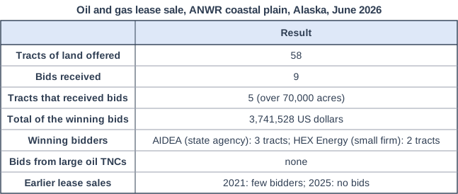
Oil and gas lease sale, ANWR coastal plain, Alaska, June 2026. Table with columns (row headings), "Result". Tracts of land offered; Result: 58 | Bids received; Result: 9 | Tracts that received bids; Result: 5 (over 70,000 acres) | Total of the winning bids; Result: 3,741,528 US dollars | Winning bidders; Result: AIDEA (state agency): 3 tracts; HEX Energy (small firm): 2 tracts | Bids from large oil TNCs; Result: none | Earlier lease sales; Result: 2021: few bidders; 2025: no bids.

Model answer

3,741,528 ÷ 2 = 1,870,764 US dollars

Explanation

Half of the total of the winning bids is 1,870,764 US dollars. This is a very small sum compared with the cost of developing an Arctic oil field, which helps to show how weak the interest in this sale was.

Mark scheme
  1. 1 mark

    1,870,764 US dollars (3,741,528 ÷ 2)

    Correct answer with no working scores full marks. Accept 1,870,764 with or without units. The answer is exact, so do not credit a rounded value such as 1.87 million, 1.9 million or 2 million US dollars.
Question 2

1 mark

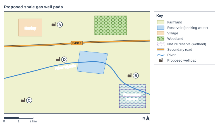
Study Figure 1, which is a map of an imaginary rural area where a company plans to extract shale gas from four well pads, labelled A, B, C and D. The map was written for this course. The River Wyndle flows from west to east, through the reservoir, which supplies drinking water.

State the compass direction of the reservoir from well pad C.

Proposed shale gas well pads. Map of a local area, 10 km from west to east and 7 km from south to north, with north at the top. Areas: the farmland shown pale yellow-green, covering the whole map; the reservoir (drinking water) shown blue, in the centre of the map; the marsh shown pale blue-green with marsh symbols, in the south-east of the map; "Fen nature reserve" (nature reserve (wetland)) shown purple hatching with a dotted purple outline, in the south-east of the map; "Hartley" (village) shown pale orange, in the north-west of the map; the woodland shown green with tree symbols, in the north-east of the map. Lines: the River Wyndle (a river, blue, named) runs from the west edge to the east edge, passing through the centre of the map; the B4310 (secondary road) runs from the west edge to the east edge, passing through the north of the map. Symbols: a proposed well pad symbol (lettered A) in the north of the map (inside the farmland); a proposed well pad symbol (lettered B) in the east of the map (inside the farmland); a proposed well pad symbol (lettered C) in the south-west of the map (inside the farmland); a proposed well pad symbol (lettered D) in the centre of the map (inside the farmland; 370 m from River Wyndle). Letters in circles: A labels a proposed well pad symbol in the north of the map; B labels a proposed well pad symbol in the east of the map; C labels a proposed well pad symbol in the south-west of the map; D labels a proposed well pad symbol in the centre of the map. The key (beside the map) shows: farmland, reservoir (drinking water), village, woodland, nature reserve (wetland), secondary road, river, proposed well pad. Below the map: a scale bar marked 0, 1 and 2 km and a north arrow pointing to the top.

Model answer

North-east

Explanation

The reservoir lies up and to the right of well pad C on the map, and north is at the top, so it is to the north-east. A common error is to give the direction the other way round (south-west), which is the direction of C from the reservoir.

Mark scheme
  1. 1 mark

    North-east (NE)

    Accept east-north-east (ENE). Do not accept north, east or south-west (the direction of C from the reservoir).

Question 3

2 marks

Identify two environmental costs that come from extracting shale gas, rather than from mining tar sands.

Choose two answers.

A Groundwater polluted by gas or fluid leaking through a faulty well casing
B Toxic tailings ponds that can leak into rivers
C Waste water containing chemicals spilled at the surface around the well
D Boreal forest, peat and soil stripped from open pits many kilometres across
E Huge volumes of river water heated and used to wash bitumen out of mined sand

Model answer

A and C

Explanation

Shale gas is produced from wells, so its water risks come from faulty well casings and from spills of the fluid and waste water at the surface. Tailings ponds, open pits and hot-water washing all belong to tar sands mining, so learn which impacts go with which source.

Mark scheme
  1. 2 marks

    A and C (Groundwater polluted by gas or fluid leaking through a faulty well casing; Waste water containing chemicals spilled at the surface around the well)

    1 mark for each correct letter. Accept the letters or the options written out. Do not credit an answer that gives more than two letters. B is incorrect: tailings ponds store the waste from processing mined tar sands. D is incorrect: open pits that strip away forest and peat are used to mine tar sands. E is incorrect: washing bitumen out of mined sand with hot water is part of tar sands processing.

Question 4

4 marks

Explain two reasons why it is difficult to restore ecosystems after tar sands have been mined.

Model answer

First, much of the land was peat bog and wetland, which built up over thousands of years. Once it has been dug away it cannot be recreated in a few decades, so its habitats and carbon store are lost.

Second, the toxic waste in tailings ponds takes decades to settle and be made safe. Until it has been cleaned up and capped, the land cannot be replanted, so the forest ecosystem cannot return for a long time.

Explanation

Each reason needs to be identified (1) and explained (1). Strong answers link the problem to the slow processes of the boreal environment, such as peat formation or slow tree growth; vague answers such as 'it costs a lot' need an explanation of why restoration is so slow or difficult.

Mark scheme
  1. 1 mark

    First reason, e.g. peat and wetlands took thousands of years to form / soil is stripped away / tailings ponds hold toxic waste for decades / cold climate and short growing season / the shape of the land and its drainage are changed

    Award 1 mark for each reason and 1 mark for its explanation, up to 2 marks per reason. The two reasons must be different. Examples: Peat bogs and wetlands built up over thousands of years (1), so they cannot be recreated quickly and their carbon store and habitats are lost (1). The soil is removed and stored in heaps (1), so it loses its structure, nutrients and organisms and new trees grow poorly (1). Tailings ponds contain fine clay and toxic water that take decades to settle (1), so the land cannot be planted for a long time (1). The growing season in the boreal forest is short (1), so replanted trees take many decades to grow into a mature forest (1). Deep pits change how water drains through the area (1), so wetlands cannot return to how they were (1). Accept any other appropriate response.

  2. 1 mark

    Explains the first reason

  3. 1 mark

    Second, different reason

  4. 1 mark

    Explains the second reason

Ready to try the rest? Every answer you write is marked against the mark scheme, so you can see exactly where the marks are.

Study Helper Hints first, answers after you try

Stuck on this one? Ask for a hint and I’ll point you in the right direction, without giving the answer away. Once you’ve checked your answer, I’ll show you how the marks are awarded.