Practise 31 exam-style questions on Tectonic hazards: impacts and management for Edexcel GCSE Geography B (Paper 1). Write your answer as you would in the exam and get it marked in seconds against the mark scheme, point by point, with the Study Helper on hand if you get stuck.
31 questions
1–8 marks each
Instant marking
No sign-up needed
20 questions, marked as you go
Sample questions with model answers
Here are 4 of the questions in this topic, each with a model answer, an explanation of why it earns the marks and the mark scheme an examiner would use.
Question 1
1 mark
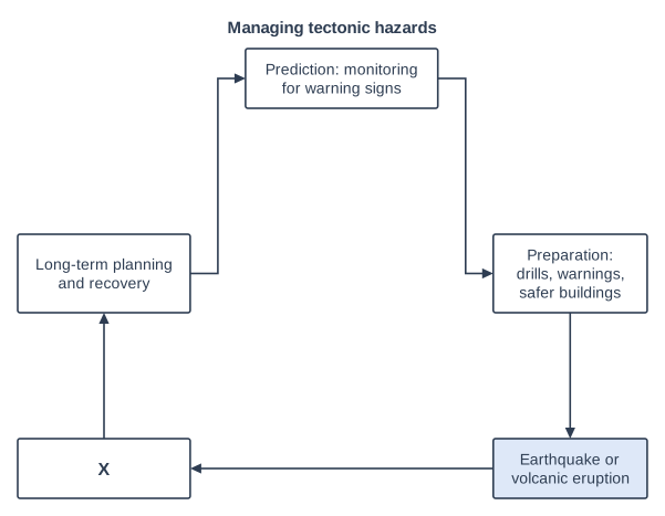
Study Figure 1, which shows how tectonic hazards can be managed.
Identify what belongs in box X.
Choose your answer.
A Monitoring the ground with seismometers
B Training and funding emergency services
C Short-term relief: rescue, shelter and emergency supplies
D Changing building codes so that new buildings are safer
Model answer
C
Explanation
Box X comes straight after the earthquake or eruption and before long-term planning and recovery, so it must be the short-term relief: rescue, shelter and emergency supplies. Reading the order of the arrows is the key to this question.
Mark scheme
1 mark
C (Short-term relief: rescue, shelter and emergency supplies)
Accept the letter or the option written out; do not credit more than one answer. A is incorrect: monitoring is prediction, which comes before the event. B is incorrect: training and funding emergency services is long-term planning. D is incorrect: new building codes are part of long-term planning and preparation. All other answers are incorrect.
Question 2
2 marks
Explain one way in which an exclusion zone around an erupting volcano can reduce the number of deaths.
Model answer
An exclusion zone means that everyone living close to the volcano is evacuated and stopped from returning. When fast-moving pyroclastic flows or lahars sweep down the slopes, nobody is there to be caught by them, so far fewer people die.
Explanation
One mark is for what the exclusion zone does (removing people from the most dangerous area) and one for explaining how this saves lives. At Merapi in 2010, widening the evacuation zone to 20 km is estimated to have saved 10,000-20,000 lives. Vague answers such as 'it keeps people safe' need developing.
Mark scheme
1 mark
Identifies a valid way, e.g. people are moved out of, and kept out of, the area most at risk from pyroclastic flows, lahars, lava flows or volcanic bombs
Examples: People living closest to the volcano are evacuated (1), so they are not there when fast-moving pyroclastic flows or lahars arrive, which they could not outrun (1). Roadblocks stop people going back to their homes or farms (1), so they are not caught by a sudden explosive eruption (1). The zone can be widened as the eruption grows (1); at Merapi, Indonesia, in 2010 the evacuation zone was extended from 15 km to 20 km, which is estimated to have saved 10,000-20,000 lives (1). Accept any other appropriate response.
1 mark
Develops the way, e.g. so people are not caught by pyroclastic flows or lahars that move too fast to escape / so people cannot return to dangerous areas
Do not credit 'it keeps people safe' without saying from what or how.
Question 3
3 marks
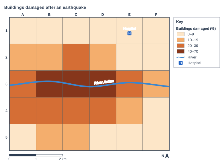
Study Figure 1, which shows the percentage of buildings damaged in each 1 km grid square of a city after an earthquake. The map was made from satellite images. The data are hypothetical and were written for this course.
Suggest one reason why the damage was greatest close to the River Arden.
Model answer
The land beside a river is often made of soft, wet sediments rather than solid rock. These sediments shake more strongly in an earthquake and can turn almost liquid (liquefaction), so buildings sink, tilt or collapse. This would explain why 40-70% of buildings were damaged in squares B3 to D3 along the River Arden.
Explanation
A Suggest question asks you to apply what you know to an unfamiliar map. The strongest reason is soft river sediments and liquefaction, which badly affected the eastern suburbs of Christchurch in 2011. One mark is for the reason and two for developing it, for example with data from the map.
Mark scheme
1 mark
Identifies a valid reason, e.g. the ground near the river is soft, wet sediment / liquefaction / the oldest buildings are near the river
Examples: The land beside a river is often made of soft, wet sediments (1), which shake more strongly than solid rock and can turn to liquid (liquefaction) during an earthquake (1), so buildings sink, tilt or collapse, as in squares B3-D3 where 40-70% were damaged (1). The oldest part of a city is often by its river (1), so these buildings were built before modern building codes (1) and are more likely to collapse when shaken (1). Areas near the river may be more crowded with buildings (1), so there were more buildings to damage and they could fall against each other (1). Accept any other appropriate response.
2 marks
Up to two further marks for linked development of the same reason (1 + 1), e.g. so the shaking is stronger / the ground loses its strength / buildings sink, tilt or collapse / use of data from Figure 1
Data from Figure 1 can support development. A second, separate reason earns no further marks. Do not credit flooding from the river unless linked to the earthquake (e.g. a damaged flood wall).
Question 4
4 marks
For a named developed country, explain two ways in which people were prepared for an earthquake or a volcanic eruption.
Model answer
In Japan, building standards introduced in 1981 require new buildings to resist strong shaking, for example with cross-bracing and rubber base isolators. This meant that relatively few buildings collapsed from the shaking in the 2011 Tohoku earthquake.
Japan also holds nationwide earthquake drills every year on 1 September, Disaster Prevention Day. Schoolchildren and workers practise taking cover and evacuating to high ground, so they know what to do when an earthquake or tsunami warning comes.
Explanation
Each way of preparing earns 1 mark and its explanation a second, ideally with detail from a named developed country such as Japan. Preparation means action taken before the hazard, so relief after the event does not count. A generic answer with no named country is limited to 3.
Mark scheme
1 mark
First way identified, e.g. buildings designed to resist earthquakes / regular earthquake drills / an early-warning system / tsunami sea walls and evacuation routes / monitoring and evacuation plans for a volcano
Max 3 if the answer is generic and makes no reference to a named developed country. Credit any appropriate named example; there is no mark for the name alone. Examples (Japan): Building standards introduced in 1981 require new buildings to resist strong shaking, using features such as cross-bracing and base isolation (1), so far fewer buildings collapsed in the 2011 Tohoku earthquake than in less prepared countries (1). Nationwide drills are held every year on 1 September, Disaster Prevention Day (1), so people know to take cover and evacuate to high ground (1). An earthquake early-warning system has sent public alerts since 2007 (1), stopping trains automatically before strong shaking arrives (1). Tsunami warnings are issued within about 3 minutes (1), so people near the coast have time to reach evacuation towers or high ground (1). Other examples: Iceland 2010, where about 700-800 people living near Eyjafjallajokull were evacuated because of the risk of floods of glacial meltwater (1), so no one was killed (1). Accept any other appropriate response.
1 mark
Explains the first way, e.g. so fewer buildings collapsed / so people knew what to do / so people had time to reach safety
1 mark
Second, different way identified
The two ways must be different. Do not credit short-term relief after the event (e.g. tents and food): the question asks about preparation.
1 mark
Explains the second way
Ready to try the rest? Every answer you write is marked against the mark scheme, so you can see exactly where the marks are.
Ctrl + Enter to check
Study HelperHints first, answers after you try
Stuck on this one? Ask for a hint and I’ll point you in the right direction, without giving the answer away. Once you’ve checked your answer, I’ll show you how the marks are awarded.