Practise 27 exam-style questions on A megacity: site, situation and structure for Edexcel GCSE Geography B (Paper 1). Write your answer as you would in the exam and get it marked in seconds against the mark scheme, point by point, with the Study Helper on hand if you get stuck.
27 questions
1–8 marks each
Instant marking
No sign-up needed
20 questions, marked as you go
Sample questions with model answers
Here are 4 of the questions in this topic, each with a model answer, an explanation of why it earns the marks and the mark scheme an examiner would use.
Question 1
1 mark
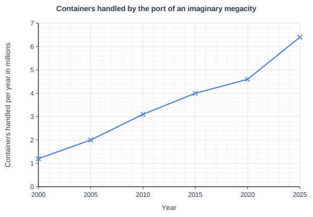
Study Figure 1, which shows the number of containers handled each year by the port of an imaginary megacity (data written for this course).
Identify the five-year period in which the number of containers handled increased the most.
Choose your answer.
A 2000-2005
B 2005-2010
C 2010-2015
D 2020-2025
Model answer
D
Explanation
The period with the largest increase is the steepest part of the line: 2020-2025 rose by 1.8 million containers. Work out each increase from the graph rather than choosing the period with the highest values. Growth in a port's trade like this is one sign of a megacity's growing global connectivity.
Mark scheme
1 mark
D (2020-2025)
Accept the letter or the option written out; do not credit more than one answer. The increase in 2020-2025 was 1.8 million (4.6 to 6.4 million), the steepest part of the line. A is incorrect: 2000-2005 rose by only 0.8 million (1.2 to 2.0 million). B is incorrect: 2005-2010 rose by 1.1 million (2.0 to 3.1 million). C is incorrect: 2010-2015 rose by 0.9 million (3.1 to 4.0 million). All other answers are incorrect.
Question 2
2 marks
Explain one way in which an international airport increases the importance of a megacity in a global context.
Model answer
An international airport gives direct flights to other world cities, so it is easier for TNCs to set up regional offices in the megacity. This brings global investment and makes the city a more important hub in the world economy.
Explanation
One mark is for a way the airport links the city to the rest of the world and the second for explaining why that makes the city more important globally (investment, TNC offices, tourism or trade). Mumbai, for example, now has two international airports: Chhatrapati Shivaji Maharaj International and Navi Mumbai International, which opened in December 2025. Vague answers such as 'more people come' need developing.
Mark scheme
1 mark
Identifies a valid way, e.g. direct flights link the city to other world cities / it attracts TNCs and business travellers / it brings international tourists / it allows high-value goods to be exported by air
Examples: Direct flights to other world cities (1) make it easier for TNCs to locate regional offices there, so more global companies invest in the city (1). It brings in large numbers of foreign tourists (1) whose spending creates jobs in hotels and services and raises the city's profile around the world (1). It allows high-value goods such as medicines to be exported quickly by air (1), linking the city's firms to global markets (1). Accept any other appropriate response.
1 mark
Develops the way, explaining how it raises the city's global importance, e.g. more global firms, investment, trade or visitors
The development must explain the link to global importance (investment, TNC offices, trade, visitors). Do not credit 'it brings more money' in isolation. Do not credit a second, different way.
Question 3
2 marks
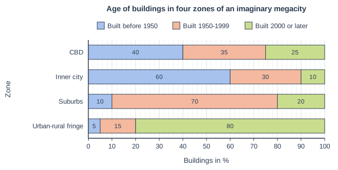
Study Figure 1, which shows the percentage of buildings built in different periods in four zones of an imaginary megacity (data written for this course).
Suggest one reason why the suburbs have the highest percentage of buildings built between 1950 and 1999.
Model answer
The megacity's population grew very quickly after 1950 as migrants arrived from rural areas. The inner city was already full, so large areas of new housing were built on farmland at the edge of the city at that time, and these areas became the suburbs.
Explanation
Building age reflects when each zone was built: the suburbs were the edge of the city during its fast growth in the second half of the twentieth century. One mark is for the reason and one for explaining how it led to most suburban buildings dating from that period. Much of Mumbai's growth after 1950, for example, was in suburbs along its railway lines.
Mark scheme
1 mark
Identifies a valid reason, e.g. the city's population grew rapidly in the second half of the 20th century / the city spread outwards onto farmland at that time / the inner city was already full, so new housing was built further out / new railways or roads let people live further from the centre
Examples: The megacity's population grew rapidly after 1950 as many migrants arrived (1), so large areas of new housing had to be built at what was then the edge of the city, and these became the suburbs (1). The inner city was already full of older housing by 1950 (1), so new homes for the growing population could only be built further out, on farmland that became the suburbs (1). New suburban railways and roads were built in this period (1), so people could live further from the centre and commute, and housing spread along them (1). Accept any other appropriate response.
1 mark
Develops the reason, explaining how it led to most suburban buildings dating from 1950-1999
Do not credit a second, different reason. Do not credit a description of the data (e.g. '70% were built in 1950-1999') as a reason.
Question 4
4 marks
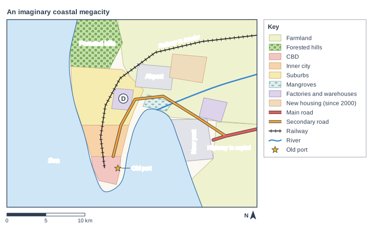
Study Figure 1, which shows an imaginary coastal megacity (written for this course). The megacity is its country's largest port.
Using Figure 1, suggest two ways in which the situation of this megacity could help it to grow.
Model answer
The railway runs from the city to the interior of the country, so farms, mines and factories inland can send their exports to the port. This creates jobs in the port and in transport, which attract migrants and make the city grow. Secondly, the highway links the new port to the capital, so companies that trade with the government and with other regions want to locate in the megacity, bringing investment and more jobs.
Explanation
Situation is the city's position in relation to other places, so use the links shown on the map: the railway to the interior, the highway to the capital, the sea and the airport. Each way earns 1 mark for the feature and 1 for explaining how it helps the city grow. Answers that use no evidence from Figure 1 are limited to 3 marks.
Mark scheme
1 mark
Identifies a first way using evidence from Figure 1, e.g. the railway links the city and its port to the interior of the country / the highway links the new port to the capital / the coastal position gives access to sea trade routes / the airport links it to other countries
Max 3 if no data or evidence from Figure 1 is used. Examples: The railway to the interior links the port to the rest of the country (1), so goods from inland farms and factories are exported through the city, creating jobs that attract migrants (1). The highway to the capital links the new port with the capital city (1), so firms that trade with the government and other regions locate in the megacity, bringing investment (1). The city is on the coast with access to the open sea (1), so it can trade with other countries and attract foreign companies (1). The airport gives international links (1), attracting tourists and TNC offices (1). Accept any other appropriate response.
1 mark
Explains how the first way helps the city to grow (jobs, trade, investment or migration)
The development must explain how the link helps the city grow. Repeating the feature in different words is not development.
1 mark
Identifies a second, different way using evidence from Figure 1
Must be a different way from the first. Do not credit the railway and the highway as two ways if both are explained in the same way (e.g. both only 'link to the interior so more trade'): no double credit. Site features (the sheltered bay, flat land) are credited only if linked to the city's position in relation to other places.
1 mark
Explains how the second way helps the city to grow
As for the first way.
Ready to try the rest? Every answer you write is marked against the mark scheme, so you can see exactly where the marks are.
Ctrl + Enter to check
Study HelperHints first, answers after you try
Stuck on this one? Ask for a hint and I’ll point you in the right direction, without giving the answer away. Once you’ve checked your answer, I’ll show you how the marks are awarded.