Plate boundaries, volcanoes and earthquake hazards
Practise 29 exam-style questions on Plate boundaries, volcanoes and earthquake hazards for Edexcel GCSE Geography B (Paper 1). Write your answer as you would in the exam and get it marked in seconds against the mark scheme, point by point, with the Study Helper on hand if you get stuck.
29 questions
1–8 marks each
Instant marking
No sign-up needed
20 questions, marked as you go
Sample questions with model answers
Here are 4 of the questions in this topic, each with a model answer, an explanation of why it earns the marks and the mark scheme an examiner would use.
Question 1
1 mark
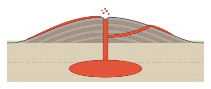
Study Figure 1, which shows a cross-section through a volcano.
Identify the type of magma most likely to have formed the volcano in Figure 1.
Choose your answer.
A Rhyolitic magma, with a very high silica content
B Basaltic magma, with a low silica content
C Basaltic magma, with a high silica content
D Andesitic magma, with a high silica content
Model answer
B
Explanation
Figure 1 shows a wide, low volcano with gentle slopes, many thin layers and long lava flows: a shield volcano. This shape forms from runny basaltic magma, which is low in silica, so lava flows a long way before it cools. Steep composite cones form from viscous andesitic magma.
Mark scheme
1 mark
B (Basaltic magma, with a low silica content)
Accept the letter or the option written out; do not credit more than one answer. A is incorrect: rhyolitic magma is very viscous and erupts explosively; it does not form wide, gently sloping cones with long lava flows. C is incorrect: basaltic magma has a low, not high, silica content. D is incorrect: andesitic magma is viscous and builds steep-sided composite volcanoes. All other answers are incorrect.
Question 2
2 marks
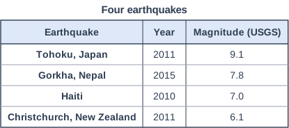
Figure 1 shows the magnitude of four earthquakes, as measured by the United States Geological Survey (USGS). Each increase of 1 in magnitude means that about 32 times more energy is released.
Calculate approximately how many times more energy was released by the Tohoku earthquake than by the Christchurch earthquake.
Show your working.
Model answer
Difference in magnitude = 9.1 - 6.1 = 3 Energy = 32 × 32 × 32 = 32,768 The Tohoku earthquake released about 33,000 times more energy.
Explanation
Because the scale is logarithmic, each step multiplies the energy by about 32, so a difference of 3 means 32 × 32 × 32 = 32,768, about 33,000 times. A common error is to multiply 32 by 3, which treats the scale as if it went up in equal steps. Another is to use 10 for each step, which gives the increase in wave amplitude rather than energy.
Mark scheme
1 mark
Method: difference in magnitude 9.1 - 6.1 = 3, so 32 × 32 × 32 (or 32³) (correct answer 32,768, about 33,000 times)
Correct answer: 32,768 times; accept it correctly rounded to at least two significant figures (32,770, 32,800 or 33,000), or 31,623 from 10 to the power 4.5 (or 31,620, 31,600 or 32,000). Correct answer with no working scores full marks (2). Award this method mark for 32 × 32 × 32 or 32³ with an arithmetic slip, or for a correct difference of 3 used with repeated multiplication by 32. Do not award the method mark for 32 × 3 = 96 (adding instead of multiplying) or for 10 × 10 × 10 = 1,000 (that is the increase in amplitude, not energy).
1 mark
32,768 (accept 32,770, 32,800 or 33,000; or 31,623, 31,620, 31,600 or 32,000 from 10 to the power 4.5)
Units are not required. Do not accept 30,000 (one significant figure), 96, 1,000 or 3,000.
Question 3
3 marks
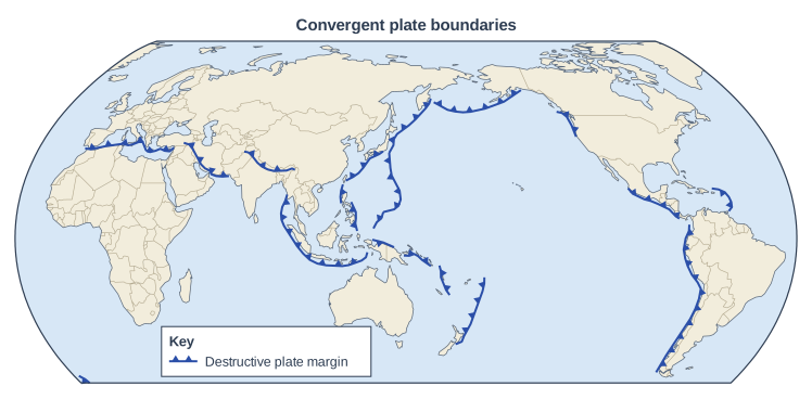
Study Figure 1, which shows the world's convergent plate boundaries.
Using Figure 1, suggest one reason why there are many convergent plate boundaries around the edges of the Pacific Ocean but very few in the Atlantic Ocean.
Model answer
The floor of the Pacific Ocean is made of oceanic plates, such as the Pacific and Nazca Plates, which are moving towards the continents and island chains around the ocean. Because oceanic crust is dense, it is subducted beneath these surrounding plates, so a ring of convergent boundaries and deep ocean trenches has formed around the edges of the Pacific. In contrast, the Atlantic Ocean is widening as its plates move apart at the Mid-Atlantic Ridge, so there is very little subduction there.
Explanation
The first mark is for a reason linked to plate movement and the development marks explain how it produces the pattern in Figure 1, such as dense oceanic crust being subducted around the Pacific, contrasted with the widening Atlantic. A Suggest question asks you to apply what you know to the figure. Describing where the boundaries are, without a reason, earns no marks.
Mark scheme
1 mark
Identifies a valid reason, e.g. the floor of the Pacific Ocean is made of oceanic plates (such as the Pacific and Nazca Plates) that are moving towards the plates around them / the Atlantic Ocean is widening as plates move apart at the Mid-Atlantic Ridge
Examples: The Pacific Ocean floor is made of oceanic plates, such as the Pacific and Nazca Plates, that are moving towards the plates around the ocean (1); this dense oceanic crust is subducted beneath the surrounding plates (1), so a ring of convergent boundaries and ocean trenches has formed around the edges of the Pacific (1). The Atlantic Ocean is getting wider as plates move apart at the Mid-Atlantic Ridge (1), so the plates on either side are moving away from each other rather than towards each other (1); the Atlantic sea floor and the continents beside it are mostly parts of the same plates, so there are no plate boundaries along most Atlantic coasts (1). Accept any other appropriate response.
2 marks
Up to two further marks for linked development of the same reason (1 + 1), e.g. the denser oceanic crust is subducted beneath the surrounding plates / this forms a ring of convergent boundaries (the Ring of Fire) / the Atlantic plates move apart so there is little subduction / evidence from Figure 1
A contrast with the other ocean can count as development of the same reason (e.g. Pacific plates are subducted whereas the Atlantic is widening). Evidence from Figure 1 (e.g. convergent boundaries along the west coasts of the Americas and around Japan, but in the Atlantic only in the Caribbean) can support development. A second, separate reason earns no further marks. Do not credit a description of the distribution with no reason, or 'the Pacific is bigger' without development.
Question 4
4 marks
Explain two reasons why the strength of the ground shaking from the same earthquake can vary from place to place.
Model answer
Places further from the epicentre feel weaker shaking, because seismic waves lose energy as they spread out and travel through the rock.
The type of ground also matters. Soft ground, such as river sediments, shakes much more than solid rock because the seismic waves are amplified as they pass into the loose material, which can even turn to liquid in a process called liquefaction.
Explanation
Each reason earns one mark and its explanation another. Distance from the epicentre and the type of ground are the two clearest reasons. Magnitude and depth do not vary within one earthquake, and building quality affects damage rather than the shaking itself.
Mark scheme
1 mark
First reason identified, e.g. distance from the epicentre
Examples: Places further from the epicentre feel weaker shaking (1) because seismic waves lose energy as they spread out and travel through the rock (1). Soft ground such as river sediments or reclaimed land shakes more than solid rock (1) because the waves are amplified as they pass into loose material, which can also turn to liquid (liquefaction) (1). Places nearer the fault that moved feel the strongest shaking (1) because that is where the energy is released (1). Accept any other appropriate response.
1 mark
Explains the first reason, e.g. because seismic waves lose energy as they spread out
1 mark
Second, different reason identified, e.g. the type of ground / rock (soft sediments or solid rock)
The two reasons must be different. Do not credit magnitude or depth as a reason: for one earthquake these are the same everywhere. Do not credit reasons about building quality or wealth: they affect damage, not the strength of the shaking.
1 mark
Explains the second reason, e.g. because soft sediments amplify the seismic waves / can liquefy
Ready to try the rest? Every answer you write is marked against the mark scheme, so you can see exactly where the marks are.
Ctrl + Enter to check
Study HelperHints first, answers after you try
Stuck on this one? Ask for a hint and I’ll point you in the right direction, without giving the answer away. Once you’ve checked your answer, I’ll show you how the marks are awarded.