Level:
Correct: 0
Incorrect: 0
Marks: 0/0
Exam Practice
Subject:
Topics:
Avg
score:
–
Topics
done:
0/21

Issue: protecting a retreating coastline

Practise 23 exam-style questions on Issue: protecting a retreating coastline for AQA GCSE Geography (Paper 3). Write your answer as you would in the exam and get it marked in seconds against the mark scheme, point by point, with an AI tutor on hand if you get stuck.

  • 23 questions
  • 1–12 marks each
  • Instant marking
  • No sign-up needed
20 questions, marked as you go

Sample questions with model answers

Here are 4 of the questions in this topic, each with a model answer, an explanation of why it earns the marks and the mark scheme an examiner would use.

Question 1

1 mark

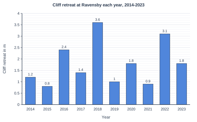
Figure 1 shows how far the cliff top at Ravensby, a village on the Holderness coast of East Yorkshire, retreated each year from 2014 to 2023.

Calculate the range of the annual cliff retreat shown in Figure 1.

Cliff retreat at Ravensby each year, 2014-2023. Bar chart of cliff retreat in m for each year: 2014 1.2, 2015 0.8, 2016 2.4, 2017 1.4, 2018 3.6, 2019 1, 2020 1.8, 2021 0.9, 2022 3.1, 2023 1.8.

Model answer

Highest = 3.6 m (2018); lowest = 0.8 m (2015). Range = 3.6 − 0.8 = 2.8 m.

Explanation

The range is the difference between the highest and lowest values, so it is a single number, not 'from 0.8 to 3.6'. A large range like this shows that erosion on this coast is very variable from year to year, mainly because some winters are much stormier and wetter than others.

Mark scheme
  1. 1 mark

    2.8 m (3.6 − 0.8)

    Units not required. Do not accept '0.8 to 3.6 m' given only as the lowest and highest values.

Question 2

2 marks

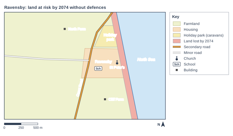
Figure 1 is a map of Ravensby, a village on the Holderness coast, showing the land that would be lost to the sea by 2074 if no defences are built. Option 1 would build a 1.2 km concrete sea wall with rock armour in front of the village and the holiday park only. The owner of Cliff Farm said: 'A wall would save the village, but my fields would still fall into the sea.'

Suggest two reasons why the owner of Cliff Farm is likely to oppose Option 1.

Ravensby: land at risk by 2074 without defences. Map of a local area, 2.4 km from west to east and 1.6 km from south to north, with north at the top. The sea (pale blue, named "North Sea") lies to the east; the coastline runs from the north edge to the south edge, passing through the east of the map. Areas: the farmland shown pale yellow-green, in the centre of the map; "Ravensby" (housing area) shown pale orange, in the centre of the map; "Holiday park" (holiday park (caravans)) shown yellow, in the north of the map; the land lost by 2074 shown red, in the east of the map. Lines: Coast Road (secondary road) runs from the north edge to the south edge, passing through the centre of the map; a minor road runs from the centre of the map to the west edge, passing through the west of the map. Symbols: the church "St Peter's" in the east of the map (inside the farmland and "Ravensby" (housing area)); the school in the centre of the map (inside the farmland and "Ravensby" (housing area)); the building "Cliff Farm" in the south of the map (inside the farmland); the building "North Farm" in the north of the map (inside the farmland). The key (beside the map) shows: farmland, housing, holiday park (caravans), land lost by 2074, secondary road, minor road, church, Sch = school, building. Below the map: a scale bar marked 0, 250 and 500 m and a north arrow pointing to the top.

Model answer

Firstly, Cliff Farm is south of the village, outside the 1.2 km stretch that the wall would protect, so his fields would keep eroding at about 1.8 m a year. Secondly, erosion could become even faster on his land just south of the end of the wall, because the wall would stop sediment from the cliffs reaching his beach, and waves could erode around the end of the defence, as happened south of Mappleton after its rock groynes were built.

Explanation

Hard engineering protects only the stretch of coast directly behind it. Because longshore drift carries sediment south along Holderness, defending one place usually starves the coast just down-drift of sediment, so erosion speeds up there. Farmland has a low value, so it is rarely protected, and landowners in England receive no compensation for land lost to erosion.

Mark scheme
  1. 1 mark

    Cliff Farm lies south of the village, outside the 1.2 km stretch the wall would protect, so the farmland would keep eroding at about 1.8 m a year

    max 2; 1 mark for each valid reason.

  2. 1 mark

    Erosion is likely to become faster on the land just south of the wall, because the defence stops sediment from the cliffs reaching the beach further south / waves erode around the end of the wall (as happened south of Mappleton)

    Accept 'terminal groyne effect' or 'outflanking' if explained.

  3. 1 mark

    The farmer would get no compensation for the farmland he loses

  4. 1 mark

    Public money would be spent protecting the village and holiday park rather than helping farmers / his land is not valuable enough to be protected

Question 3

4 marks

Monitoring at Ravensby, a village on the Holderness coast of East Yorkshire, shows that the boulder clay cliff top retreated by only 0.8 m in 2015 but by 3.6 m in 2018.

Suggest reasons why the amount of cliff retreat at Ravensby varies so much from year to year.

Model answer

One reason is that some winters are much stormier than others. In a stormy year strong north-easterly winds blow over a long fetch across the North Sea, creating large destructive waves that erode the foot of the cliff by hydraulic action and abrasion, especially if storm surges or high spring tides let the waves reach the cliff. A second reason is rainfall. In a very wet year the boulder clay becomes saturated, heavier and weaker, so large slumps occur that can remove several metres of cliff top in one go. In a drier, calmer year, such as 2015 may have been, the slumped material at the foot of the cliff can protect it for a while, so much less retreat occurs.

Explanation

Erosion on soft-rock coasts happens in bursts rather than at a steady rate. Level 2 answers suggest at least two factors that vary (storms, rainfall, tides, beach level) and explain how each changes the amount of erosion or slumping; listing factors without explanation stays in Level 1.

Mark scheme
  1. 4 marks

    Levels of response (4 marks).
    Level 2 (3-4 marks): clear, developed suggestions of two or more factors that change from year to year, each linked to how it changes the rate of erosion or mass movement of the boulder clay cliffs.
    Level 1 (1-2 marks): basic suggestions, e.g. 'there were more storms', with little or no development.
    0 marks: nothing worthy of credit.

    Indicative content (not a checklist; credit other valid points): the number and strength of winter storms varies - strong north-easterly winds blowing over a long fetch create large destructive waves; storm surges raise sea level so waves reach the cliff foot; storms that coincide with high spring tides cause the most erosion; rainfall varies - a wet year saturates the boulder clay, making it heavier and weaker, so large slumps occur and can remove several metres of cliff at once; the beach level varies - when storms strip away the sand, the cliff foot is exposed to waves; slumped material at the cliff foot can protect it for a while until the sea removes it, so retreat happens in bursts; cold winters with freeze-thaw or wetting and drying can crack the clay; measurement at one point may pick up one large slump.

Question 4

9 marks

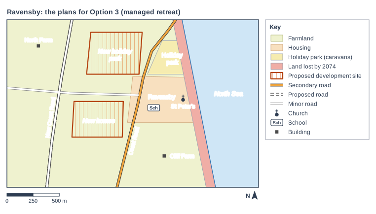
Option 3 for Ravensby, a village on the eroding Holderness coast, is managed retreat. No new defences would be built and the cliff would continue to retreat by about 1.8 m a year. The owners of the 42 homes at risk within 50 years would receive up to £60 000 each and could build new homes on council land west of the village; Coast Road would be moved more than 1 km inland; and the holiday park would receive a £1 million grant to move its caravans onto farmland further inland. The total cost would be about £7 million. Figure 1 shows the plans.

To what extent would Option 3 be a sustainable way of managing the coast at Ravensby?

Ravensby: the plans for Option 3 (managed retreat). Map of a local area, 2.4 km from west to east and 1.6 km from south to north, with north at the top. The sea (pale blue, named "North Sea") lies to the east; the coastline runs from the north edge to the south edge, passing through the east of the map. Areas: the farmland shown pale yellow-green, in the centre of the map; "Ravensby" (housing area) shown pale orange, in the centre of the map; "Holiday park" (holiday park (caravans)) shown yellow, in the north of the map; the land lost by 2074 shown red, in the east of the map; "New holiday park" (proposed development site) shown orange line shading with a solid orange-brown outline, in the north of the map; "New homes" (proposed development site) shown orange line shading with a solid orange-brown outline, in the centre of the map. Lines: Coast Road (secondary road) runs from the north edge to the south edge, passing through the centre of the map; a minor road runs from the centre of the map to the west edge, passing through the west of the map; New Coast Road (proposed road) runs from the north edge to the south edge, passing through the west of the map. Symbols: the church "St Peter's" in the east of the map (inside the farmland and "Ravensby" (housing area)); the school in the centre of the map (inside the farmland and "Ravensby" (housing area)); the building "Cliff Farm" in the south of the map (inside the farmland); the building "North Farm" in the north-west of the map (inside the farmland). The key (beside the map) shows: farmland, housing, holiday park (caravans), land lost by 2074, proposed development site, secondary road, proposed road, minor road, church, Sch = school, building. Below the map: a scale bar marked 0, 250 and 500 m and a north arrow pointing to the top.

Model answer

A sustainable solution meets the needs of people today without harming the ability of future generations to meet theirs, balancing social, economic and environmental needs.

Environmentally, Option 3 is very sustainable. It works with natural processes instead of against them. No concrete, imported rock or dredged sand is needed, and the eroding boulder clay cliffs would continue to supply sediment that longshore drift carries south to build beaches in other villages and Spurn Head nature reserve. Unlike groynes or a sea wall, it would not starve the coast further south of sediment.

Economically, it is also sustainable. At about £7 million it costs less than half as much as Options 1 and 2, and it has no maintenance costs. As sea level rises, hard defences would have to be raised or rebuilt, but managed retreat does not need upgrading, so it does not leave a bill for future generations. Figure 1 shows that the new holiday park site and the new homes would be on farmland west of the village, well away from the land that will be lost by 2074, so the park's 35 jobs and visitor spending could continue and the new homes would be safe for a long time. The new Coast Road would keep the village connected.

However, it is much less sustainable socially. The owners of 42 homes would receive at most £60 000, less than a third of what a home is worth, so many would lose most of their savings and suffer great stress, particularly elderly residents. Some families might leave, weakening the community, and in the long term St Peter's Church, the shop and the pub would be lost. Farmers would lose land to erosion without compensation and would also lose fields to the new road, homes and holiday park. At Happisburgh in Norfolk, where a similar approach was used, homes were bought and demolished and the caravan park was moved inland, but residents still lost their homes and their community changed.

Overall, Option 3 is sustainable to a large extent because it is the best option for the environment and the cheapest in the long term. However, it is only partly sustainable socially, so it would be more sustainable if the compensation were closer to the real value of people's homes.

Explanation

Level 3 answers define sustainability, assess all three strands (social, economic, environmental) and future generations, use evidence from the map and information (costs, compensation, the safe new sites), and reach a judgement on the extent rather than simply saying 'it is sustainable'. Recognising that an option can be environmentally sustainable but socially unfair shows the balance examiners look for.

Mark scheme
  1. 9 marks

    Levels of response (9 marks).
    Level 3 (7-9 marks): thorough assessment of the sustainability of Option 3, weighing its social, economic and environmental effects for present and future generations; detailed understanding of managed retreat and natural coastal processes; reaches a clear, substantiated judgement on the extent to which it is sustainable; makes effective use of evidence from Figure 1 and the information given, with accurate own knowledge.
    Level 2 (4-6 marks): clear discussion of some aspects of sustainability, which may be unbalanced (e.g. mainly environmental or mainly social); a judgement that is only partly supported; some use of Figure 1 or the information.
    Level 1 (1-3 marks): basic points about Option 3 with little reference to sustainability; little or no use of the resources; no clear judgement.
    0 marks: nothing worthy of credit.

    Indicative content (not a checklist; credit other valid points): sustainable means meeting the needs of people today without harming future generations, balancing social, economic and environmental aims; environmental: works with natural processes, the cliffs keep supplying sediment to beaches further south and to Spurn Head, no concrete or imported rock, no dredging, no starving of down-drift beaches; economic: cheapest option (£7 million against £14.8-16 million), no maintenance costs, no need to raise defences as sea level rises, so affordable for future generations; Figure 1 shows new homes and a new holiday park site on farmland west of the village, outside the land lost by 2074, so they should be safe for many decades; the holiday park keeps its 35 jobs and tourist spending if it moves successfully; the new road keeps the village connected; social: compensation of up to £60 000 is far below the value of a home (about £200 000), so residents lose wealth and may suffer stress; the community may break up; St Peter's Church and the village shop and pub will eventually be lost; farmers lose land without compensation and lose more land to the new homes, holiday park and road (greenfield land); the coast keeps retreating, so the problem moves inland and will need managing again in future; judgement, e.g. environmentally and economically sustainable but less socially sustainable unless compensation is fairer; real examples: Happisburgh in Norfolk, where homes were bought and demolished and the caravan park moved inland, and Medmerry in West Sussex, where managed realignment created new wetland habitat.

Ready to try the rest? Every answer you write is marked against the mark scheme, so you can see exactly where the marks are.

AI Tutor Hints first, answers after you try

Hi! Stuck? Ask me for a hint and I’ll help you work it out. Once you’ve checked your answer I can explain exactly where the marks are.