Level:
Correct: 0
Incorrect: 0
Marks: 0/0
Exam Practice
Subject:
Topics:
Avg
score:
–
Topics
done:
0/21

Issue: new housing on the edge of a city

Practise 23 exam-style questions on Issue: new housing on the edge of a city for AQA GCSE Geography (Paper 3). Write your answer as you would in the exam and get it marked in seconds against the mark scheme, point by point, with an AI tutor on hand if you get stuck.

  • 23 questions
  • 1–12 marks each
  • Instant marking
  • No sign-up needed
20 questions, marked as you go

Sample questions with model answers

Here are 4 of the questions in this topic, each with a model answer, an explanation of why it earns the marks and the mark scheme an examiner would use.

Question 1

1 mark

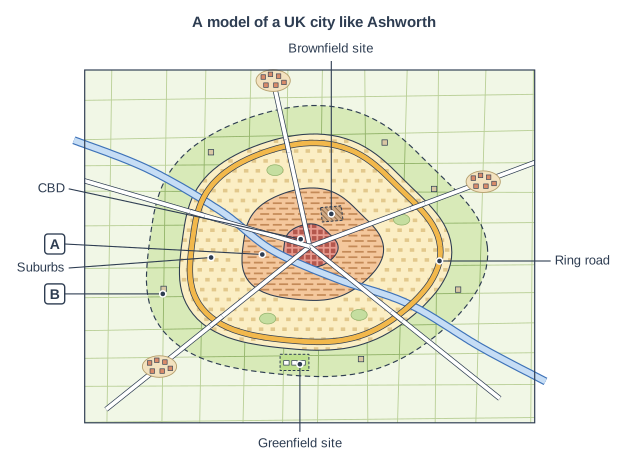
Figure 1 is a model of a UK city like Ashworth, a growing city in northern England that needs 10 000 new homes.

Name the zone labelled A, where brownfield sites such as old docks and factories are often found.

Land-use zones in a UK city (plan view). Heading: "A model of a UK city like Ashworth". A plan (map) of a city drawn as rings, one inside another. At the centre, where the main roads meet, is a small dark red zone of densely packed blocks. Round it is an orange ring with tight rows of small buildings, then a wide pale yellow ring with scattered houses and small parks, then a pale green ring of fields with a few scattered buildings, whose outer edge is a dashed line. Beyond that are open fields with three small villages on the roads. Five roads run out from the centre in all directions. Also: a thick orange road loops right round the city near the outer edge of the pale yellow ring; a blue river crosses the city from the top left to the bottom right, passing next to the centre; a small brown hatched plot with a dashed outline is in the orange ring, above and to the right of the centre; a bright green field with a dashed outline and three small white house outlines is in the pale green ring below the centre. The label "CBD" points to the small dark red zone at the centre, where the roads meet; label A points to the orange ring with rows of small buildings around the centre; the label "Suburbs" points to the wide pale yellow ring with scattered houses and small parks; label B points to the pale green ring of fields with a few buildings, at the edge of the built-up area (inside the dashed line); the label "Brownfield site" points to the small brown hatched plot with a dashed outline in the orange ring, above and to the right of the centre; the label "Greenfield site" points to the bright green field with a dashed outline and three white house outlines, in the pale green ring below the centre; the label "Ring road" points to the thick orange road that loops right round the city near the outer edge of the pale yellow ring.

Model answer

The inner city.

Explanation

The inner city surrounds the CBD and was where most factories, docks and terraced housing for workers were built in the nineteenth century. When industry declined, much of this land became derelict, creating brownfield sites that can be regenerated.

Mark scheme
  1. 1 mark

    Inner city

    Accept 'inner-city zone' or 'twilight zone'. Do not accept CBD or suburbs.

Question 2

2 marks

Option 1 for Ashworth, a growing city in northern England, is to build 10 000 houses at Thornley Fields, farmland in the green belt on the south-west edge of the city, next to a motorway.

Suggest two reasons why house-building companies prefer Option 1.

Model answer

Firstly, farmland is much cheaper to buy than land in the city, and there are no old buildings to demolish or contaminated land to clean up, so building is cheaper and quicker. Secondly, houses with gardens next to a motorway are popular with families who commute by car, so the company can sell them easily at good prices and make a larger profit.

Explanation

Developers are businesses, so they prefer sites where costs are low and profits high. Greenfield sites usually win on both counts, which is why planning rules such as the green belt are needed to steer development towards brownfield land.

Mark scheme
  1. 1 mark

    Farmland is cheaper to buy than land in the city

    max 2; 1 mark for each valid reason.

  2. 1 mark

    No need to demolish old buildings or clean up contaminated land, so building is cheaper and quicker

  3. 1 mark

    Easy access for construction traffic and future residents from the motorway

  4. 1 mark

    Houses with gardens on the edge of the city sell for higher prices / are popular with families, so profits are higher

  5. 1 mark

    A large, open, flat site allows standard house designs to be built quickly and efficiently

Question 3

4 marks

Figure 1 shows the unemployment rate in the wards of eastern Ashworth, a growing city in northern England, and the Eastgate Docks site, where Option 2 would build 10 000 new homes with new shops, offices and an extended tram line.

Using Figure 1, explain how Option 2 could benefit the people living in the wards around Eastgate Docks.

Unemployment rate by ward, eastern Ashworth. Map of a local area, 6 km from west to east and 4 km from south to north, with north at the top. Areas: the Eastgate Docks (Option 2 site) shown red cross-hatching with a dashed red outline, in the centre of the map. Lines: the River Ash (a river, blue, named) runs from the west edge to the east edge, passing through the centre of the map. Choropleth map of unemployment rate (%): zones are shaded in 4 classes, lighter for lower and darker for higher (key: 0–4 (the lightest orange-brown), 5–9 (light orange-brown), 10–14 (dark orange-brown), 15–20 (the darkest orange-brown)). Zones (names printed in them): "Central" in the west of the map: 5–9 (value 6 printed); "Eastgate" in the centre of the map: 15–20 (value 15 printed); "Dockside" in the east of the map: 15–20 (value 18 printed); "Riverside" in the south of the map: 10–14 (value 13 printed); "Northfield" in the north-west of the map: 5–9 (value 7 printed); "Kingsway" in the north of the map: 5–9 (value 9 printed); "Southbank" in the south-west of the map: 5–9 (value 8 printed); "Parkhill" in the north-east of the map: 5–9 (value 5 printed); "Moorside" in the south-east of the map: 0–4 (value 4 printed). The key (beside the map) shows: [Unemployment rate (%)], 0–4, 5–9, 10–14, 15–20, Eastgate Docks (Option 2 site), river. Below the map: a scale bar marked 0, 1 and 2 km and a north arrow pointing to the top.

Model answer

Figure 1 shows that Eastgate Docks lies in Eastgate and Dockside, the two wards with the highest unemployment in eastern Ashworth, at 15% and 18%, compared with between 4% and 9% in most other wards. Option 2 could reduce this. Building 10 000 homes would create construction jobs for local people, and the new shops and offices would provide permanent jobs. The new residents would spend money in local businesses, creating more jobs through a positive multiplier effect. The extended tram line would also make it easier for people in Eastgate and Dockside to reach jobs in other parts of the city. Cleaning up the derelict docks would improve the environment and the image of the area, encouraging further investment.

Explanation

Level 2 answers use the map's data to show that the site lies in the most deprived wards and then explain how regeneration could help those residents (jobs, multiplier effect, transport, environment). Good answers may also note that benefits only reach existing residents if they get the jobs and can afford to stay.

Mark scheme
  1. 4 marks

    Levels of response (4 marks).
    Level 2 (3-4 marks): clear, developed explanation of how regeneration could reduce deprivation and improve the area for existing residents, linked to evidence from Figure 1 (e.g. the high unemployment in Eastgate and Dockside).
    Level 1 (1-2 marks): basic statements, e.g. 'it would create jobs', with little development; little or no use of Figure 1.
    0 marks: nothing worthy of credit.

    Indicative content (not a checklist; credit other valid points): Figure 1 shows the docks lie in Eastgate (15%) and Dockside (18%), the wards with the highest unemployment, with Riverside (13%) nearby, compared with 4-9% in most other wards; construction would create jobs for local people; new shops, offices and services would provide permanent jobs; more residents with money to spend would support local businesses (positive multiplier effect); derelict, unsafe land would be cleaned up and made attractive, improving the environment and the area's image; the extended tram line would improve access to jobs elsewhere in the city; affordable homes could reduce overcrowding and the waiting list; new parks, riverside walks and community facilities; possible downside (credit if linked): rising house prices and rents could push existing residents out (gentrification), so benefits depend on local people getting the jobs and affordable homes.

Question 4

9 marks

Option 2 for Ashworth, a growing city in northern England, is to regenerate Eastgate Docks, derelict docks and old industrial land about 3 km from the city centre. It would provide 10 000 mostly high-density flats (25% affordable), new shops and offices, riverside parks and an extended tram line. The public cost would be about £320 million, including cleaning up contaminated land and building flood defences beside the River Ash, and the first homes would be ready in 2031. Unemployment in the surrounding wards is 15-18%.

To what extent would Option 2 be a sustainable way of providing new homes for Ashworth?

Model answer

A sustainable housing development meets people's needs today without harming the environment or the ability of future generations to meet their needs.

Environmentally, Option 2 is very sustainable. It reuses derelict land instead of building on countryside, so no green belt is lost and the city does not sprawl outwards. The contaminated land would be cleaned up, and high-density flats use land efficiently. Because the site is only about 3 km from the city centre and would have an extended tram line, many residents could walk, cycle or use public transport to reach jobs and services; in similar inner-city areas only about 30% of people drive to work. This would mean less congestion, air pollution and carbon emissions than building on the edge of the city. New riverside parks would also improve the environment.

Socially and economically, it would bring major benefits to one of the most deprived parts of the city. The surrounding wards have unemployment of 15-18%, and the construction work, new shops and offices would create jobs, while new residents spending money locally would start a positive multiplier effect. A quarter of the homes would be affordable, and regeneration would improve the area's image, as happened at Salford Quays, where derelict docks became MediaCityUK.

However, there are weaknesses. At £320 million it has the highest public cost, more than twice that of Thornley Fields, and the first homes would not be ready until 2031, while people need homes now. Developers are reluctant because of the clean-up costs and because many buyers want houses with gardens, so the scheme could stall. Mostly flats may not suit families with children. Rising prices could push existing residents out of the area, so the people it is meant to help might not benefit. The site is beside the River Ash, so flood risk must be managed, especially as climate change brings wetter winters.

Overall, Option 2 is sustainable to a large extent, because it protects the countryside, reduces car use and regenerates a deprived area. Its sustainability is reduced by its high cost, slow delivery and the risk of gentrification, so it would be most sustainable if it included more family homes and guaranteed affordable housing and jobs for local people.

Explanation

Level 3 answers define sustainability, assess social, economic and environmental strands with evidence from the information (unemployment, cost, timing, transport), use a real example such as Salford Quays or London Docklands, and reach a clear 'to what extent' judgement that recognises both strengths and weaknesses.

Mark scheme
  1. 9 marks

    Levels of response (9 marks).
    Level 3 (7-9 marks): thorough assessment of the sustainability of Option 2, weighing social, economic and environmental effects for present and future generations; detailed understanding of brownfield regeneration and sustainable urban living; reaches a clear, substantiated judgement on the extent to which it is sustainable; makes effective use of the information given and accurate own knowledge, e.g. a real regeneration scheme.
    Level 2 (4-6 marks): clear discussion of some aspects of sustainability, which may be unbalanced; a judgement that is only partly supported; some use of the information.
    Level 1 (1-3 marks): basic points about Option 2 with little reference to sustainability; no clear judgement.
    0 marks: nothing worthy of credit.

    Indicative content (not a checklist; credit other valid points): sustainable means meeting today's needs without harming future generations, balancing social, economic and environmental aims; environmental - reuses derelict land, so no countryside or green belt is lost and urban sprawl is avoided; cleans up contaminated land; high density uses land efficiently; residents close to jobs and services can walk, cycle or use the tram (in similar inner-city areas only about 30% drive), reducing congestion, pollution and carbon emissions; riverside parks improve the environment; social - regeneration brings homes, jobs and services to deprived wards with 15-18% unemployment; 25% affordable homes; improves the area's image and safety; but flats may not suit families with children, and rising prices may push out existing residents (gentrification); economic - creates jobs and attracts investment (multiplier effect); but the highest public cost (£320 million) and slowest to deliver (2031), and developers are reluctant, so the scheme may stall; flood risk beside the river must be managed, and climate change could increase it; real examples, e.g. Salford Quays (MediaCityUK), London Docklands or the Olympic Park at Stratford; judgement, e.g. the most sustainable option to a large extent environmentally and socially, but expensive and slow, so it needs strong public funding and a good mix of homes.

Ready to try the rest? Every answer you write is marked against the mark scheme, so you can see exactly where the marks are.

AI Tutor Hints first, answers after you try

Hi! Stuck? Ask me for a hint and I’ll help you work it out. Once you’ve checked your answer I can explain exactly where the marks are.