Level:
Correct: 0
Incorrect: 0
Marks: 0/0
Exam Practice
Subject:
Topics:
Avg
score:
–
Topics
done:
0/21

Atlas maps and distributions

Practise 28 exam-style questions on Atlas maps and distributions for AQA GCSE Geography (Paper 3). Write your answer as you would in the exam and get it marked in seconds against the mark scheme, point by point, with an AI tutor on hand if you get stuck.

  • 28 questions
  • 1–6 marks each
  • Instant marking
  • No sign-up needed
20 questions, marked as you go

Sample questions with model answers

Here are 4 of the questions in this topic, each with a model answer, an explanation of why it earns the marks and the mark scheme an examiner would use.

Question 1

1 mark

The approximate coordinates of four cities are given below.

A 51°N, 0°
B 34°S, 151°E
C 41°N, 74°W
D 1°N, 104°E

Which city is in the southern hemisphere and east of the Prime Meridian? Give the letter.

Model answer

B

Explanation

S means south of the Equator (the southern hemisphere) and E means east of the Prime Meridian, so only B fits; it is Sydney in Australia. D is east of the Prime Meridian but just north of the Equator (Singapore), A is London and C is New York.

Mark scheme
  1. 1 mark

    B (34°S, 151°E)

    Do not accept more than one answer. Naming the city (Sydney) is not required.
Question 2

2 marks

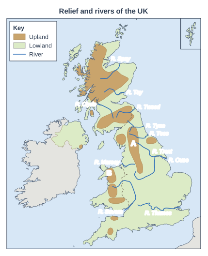
Figure 1 shows the relief and main rivers of the UK.

Using Figure 1, describe the direction in which most of the main rivers in England flow, and suggest one reason for this.

Map of the United Kingdom and Ireland, titled "Relief and rivers of the UK". The UK is drawn in green (lowland) with the uplands in brown. France and the Republic of Ireland are shown in grey. Dashed lines mark the borders between the countries of the UK. The Shetland Islands are shown in a separate box in the top right corner. Upland areas (brown): the Scottish Highlands (Grampian Mountains and North-West Highlands) in Scotland, the Southern Uplands in Scotland, the Lake District (Cumbrian Mountains) in England, the Pennines in England, the North York Moors in England, Snowdonia in Wales, the Cambrian Mountains in Wales, the Brecon Beacons in Wales, Dartmoor in England, Exmoor in England and the Mourne Mountains in Northern Ireland. The rest of the land is lowland (green); the uplands are mainly in the north and west of the UK and the lowlands in the south and east. Blue lines show rivers: the River Thames, the River Severn, the River Trent, the River Ouse (Yorkshire), the River Tyne, the River Tees, the River Tweed, the River Tay, the River Spey, the River Clyde and the River Mersey. Names printed (near each river mouth or beside the river) for the River Thames, the River Severn, the River Trent, the River Ouse (Yorkshire), the River Tyne, the River Tees, the River Tweed, the River Tay, the River Spey, the River Clyde and the River Mersey. Points: the letter A printed on the map near the centre of the map (about 65% of the way across from the left and 55% of the way down); the letter B printed on the map near the centre of the map (about 55% of the way across from the left and 65% of the way down). The key (in a box on the map) shows: "Upland", "Lowland" and "River".

Model answer

Most of the main rivers in England, such as the Thames, Tyne, Tees and Trent, flow eastwards into the North Sea. This is because the uplands, such as the Pennines, are in the west and north, so the rivers rise there and flow downhill towards the lowlands and the sea in the east.

Explanation

Rivers flow downhill from their source on high ground to their mouth at the sea, so the drainage pattern follows the relief. A few rivers, such as the Mersey and the Severn, flow west or south because they rise on the western side of the uplands.

Mark scheme
  1. 1 mark

    Most flow east / towards the east coast and the North Sea, e.g. the Thames, Tyne, Tees, Trent and Ouse (via the Humber)

    1 for the direction (with or without examples), 1 for a reason linked to relief. Accept south-east or north-east if linked to flowing to the North Sea.

  2. 1 mark

    The highest land (the Pennines, the Lake District, the Welsh uplands) is in the west and north, so rivers rise in the uplands and flow downhill to the lower land and the sea in the east

Question 3

3 marks

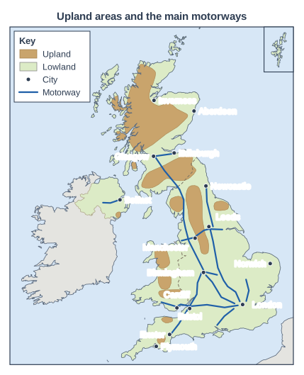
Figure 1 shows the upland areas and the main motorways in the UK.

Describe the pattern of the motorway network shown.

Map of the United Kingdom and Ireland, titled "Upland areas and the main motorways". The UK is drawn in green (lowland) with the uplands in brown. France and the Republic of Ireland are shown in grey. Dashed lines mark the borders between the countries of the UK. The Shetland Islands are shown in a separate box in the top right corner. Upland areas (brown): the Scottish Highlands (Grampian Mountains and North-West Highlands) in Scotland, the Southern Uplands in Scotland, the Lake District (Cumbrian Mountains) in England, the Pennines in England, the North York Moors in England, Snowdonia in Wales, the Cambrian Mountains in Wales, the Brecon Beacons in Wales, Dartmoor in England, Exmoor in England and the Mourne Mountains in Northern Ireland. The rest of the land is lowland (green); the uplands are mainly in the north and west of the UK and the lowlands in the south and east. Cities marked with dots and named: London, Birmingham, Manchester, Leeds, Bristol, Cardiff, Glasgow, Edinburgh, Newcastle, Exeter, Belfast, Aberdeen, Inverness, Norwich and Plymouth. Lines drawn: a line from England (about 15 km north-west of London) to England (about 5 km south-east of Leeds), heading generally north (key: "Motorway"); a line from England (about 15 km east of Leeds) to England (about 5 km south of Newcastle), heading generally north; a line from England (about 20 km east of Coventry) to England (at Carlisle), heading generally north; a line from England (at Carlisle) to Scotland (about 5 km south-east of Glasgow), heading generally north-west; a line from Scotland (at Glasgow) to Scotland (about 5 km west of Edinburgh), heading generally east; a line from England (about 5 km east of Liverpool) to England (about 30 km south-east of York), heading generally east; a line from England (about 15 km west of London) to Wales (at Swansea), heading generally west; a line from England (about 5 km west of Birmingham) to England (at Exeter), heading generally south-west; a line from England (about 25 km west of London) to England (about 10 km south-east of Birmingham), heading generally north-west; a line from England (about 15 km north-east of London) to England (at Cambridge), heading generally north; a line from England (about 30 km east of Reading) to England (about 5 km north-east of Southampton), heading generally south-west; a line from Northern Ireland (at Belfast) to Northern Ireland (about 55 km west of Belfast), heading generally west. The key (in a box on the map) shows: "Upland", "Lowland", "City" and "Motorway".

Model answer

Several motorways radiate out from London, linking it to Birmingham, Leeds, Bristol, South Wales and Southampton. The network links the largest cities, such as London, Birmingham, Manchester and Glasgow, and is densest in central England. Long routes run north on both sides of the Pennines, and the western route continues into Scotland to Glasgow. There are no motorways in northern Scotland, so none reach Aberdeen or Inverness, and none in Cornwall, East Anglia or most of Wales.

Explanation

Describe the overall shape of the network (radial from London, linking the big cities), where it is densest and where there are gaps. Naming cities and areas from the map turns a general statement into a creditworthy point.

Mark scheme
  1. 1 mark

    Many motorways radiate out from London (e.g. towards Leeds, Birmingham, Bristol and South Wales, Southampton and Cambridge)

    max 3; 1 mark per valid descriptive point. Credit named cities, motorways or areas as evidence.

  2. 1 mark

    Motorways link the largest cities, e.g. London, Birmingham, Manchester, Leeds and Glasgow

  3. 1 mark

    The network is densest in England, especially the Midlands, the North West and the south-east

  4. 1 mark

    Long north-south routes run through England to Scotland (e.g. the M6 and M74 to Glasgow, the M1 and A1(M) to Newcastle), with east-west links such as Liverpool-Manchester-Leeds

  5. 1 mark

    There are few or no motorways in northern Scotland (none to Aberdeen or Inverness), central and north Wales (only one along the south coast), Devon and Cornwall beyond Exeter, or East Anglia (none to Norwich)

  6. 1 mark

    Only one short motorway is shown in Northern Ireland, leading west from Belfast

Question 4

6 marks

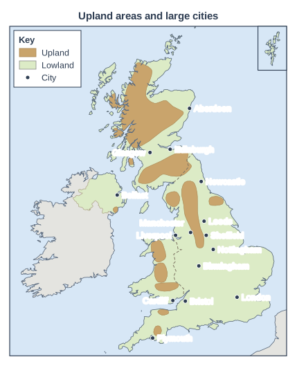
Figure 1 shows upland areas and some large cities in the UK.

Using Figure 1 and your own knowledge, explain the relationship between relief and the location of large cities in the UK.

Map of the United Kingdom and Ireland, titled "Upland areas and large cities". The UK is drawn in green (lowland) with the uplands in brown. France and the Republic of Ireland are shown in grey. Dashed lines mark the borders between the countries of the UK. The Shetland Islands are shown in a separate box in the top right corner. Upland areas (brown): the Scottish Highlands (Grampian Mountains and North-West Highlands) in Scotland, the Southern Uplands in Scotland, the Lake District (Cumbrian Mountains) in England, the Pennines in England, the North York Moors in England, Snowdonia in Wales, the Cambrian Mountains in Wales, the Brecon Beacons in Wales, Dartmoor in England, Exmoor in England and the Mourne Mountains in Northern Ireland. The rest of the land is lowland (green); the uplands are mainly in the north and west of the UK and the lowlands in the south and east. Cities marked with dots and named: London, Birmingham, Manchester, Liverpool, Leeds, Sheffield, Newcastle, Bristol, Cardiff, Glasgow, Edinburgh, Belfast, Nottingham, Aberdeen and Plymouth. The key (in a box on the map) shows: "Upland", "Lowland" and "City".

Model answer

Figure 1 shows that almost all of the large cities in the UK are in lowland areas. London, Birmingham, Nottingham and Bristol are all in the lowlands of southern and central England, and in Scotland, Glasgow and Edinburgh lie in the Central Lowlands between the Scottish Highlands and the Southern Uplands. There are no large cities in the Highlands or in the middle of the Welsh uplands; Cardiff is on the coastal lowland to the south of them.

This is because lowland areas are much better for building and growth. Flat land is easier and cheaper to build houses, factories, roads and railways on. Lowlands also have more fertile soils and a milder climate, which allowed farming to support large populations when towns first grew. Many cities also grew as ports on lowland rivers and estuaries, such as London on the Thames, Liverpool on the Mersey and Glasgow on the Clyde. Upland areas, by contrast, are steep, cold, wet and exposed, with thin soils and poor transport links, so they are thinly populated.

However, the relationship is not simple. Manchester, Leeds and Sheffield are right on the edges of the Pennines. They grew during the Industrial Revolution because fast-flowing streams from the uplands provided water power for mills and nearby coalfields provided fuel. This shows that relief influences the location of cities, but human factors such as industry and trade also matter.

Explanation

A Level 3 answer describes the relationship using named cities and upland areas from the figure, explains why lowlands attract cities (flat land, soils, climate, transport, ports) and why uplands do not, and notices exceptions such as the Pennine-edge cities. Answers that only describe the map, or that explain without using the map, stay in Level 2 or below.

Mark scheme
  1. 6 marks

    Levels of response (6 marks).
    Level 3 (5-6 marks): detailed, well-developed explanation of the relationship between relief and the location of cities, supported by specific evidence from Figure 1 (named cities and upland areas); recognises exceptions or other factors that complicate the relationship.
    Level 2 (3-4 marks): clear explanation of some reasons why most cities are in lowland areas, with some use of Figure 1.
    Level 1 (1-2 marks): basic statements (e.g. 'cities are in lowland areas') with little explanation or use of Figure 1.
    0 marks: nothing worthy of credit.

    Indicative content (not a checklist; credit other valid points): almost all the large cities shown are in lowland areas (London, Birmingham, Nottingham, Bristol, Newcastle, Liverpool, Belfast); none are in the Scottish Highlands or the middle of the Welsh uplands; Glasgow and Edinburgh lie in the Central Lowlands between the Highlands and the Southern Uplands; Cardiff is on the coastal lowland south of the Welsh uplands; Aberdeen is on coastal lowland east of the Highlands; reasons: flat land is easier and cheaper to build on; fertile soils and a milder climate supported farming and early settlements; roads, railways and canals are easier to build on flat land; lowland rivers and estuaries gave sites for ports (London on the Thames, Liverpool on the Mersey, Glasgow on the Clyde, Newcastle on the Tyne); uplands are steep, high, cold, wet and exposed with thin, poor soils, so few people live there; exceptions: Manchester, Leeds and Sheffield are on the edges of the Pennines, where fast-flowing streams gave water power and coalfields provided fuel during the Industrial Revolution; Plymouth is close to Dartmoor; other human factors such as trade, industry and London's role as the capital also matter.

Ready to try the rest? Every answer you write is marked against the mark scheme, so you can see exactly where the marks are.

AI Tutor Hints first, answers after you try

Hi! Stuck? Ask me for a hint and I’ll help you work it out. Once you’ve checked your answer I can explain exactly where the marks are.