Fieldwork: questions, hypotheses and site selection
Practise 28 exam-style questions on Fieldwork: questions, hypotheses and site selection for AQA GCSE Geography (Paper 3). Write your answer as you would in the exam and get it marked in seconds against the mark scheme, point by point, with an AI tutor on hand if you get stuck.
28 questions
1–12 marks each
Instant marking
No sign-up needed
20 questions, marked as you go
Sample questions with model answers
Here are 4 of the questions in this topic, each with a model answer, an explanation of why it earns the marks and the mark scheme an examiner would use.
Question 1
1 mark
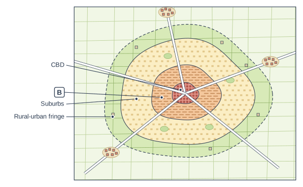
Figure 1 shows a model of land use in a UK city. Urban fieldwork enquiries often test whether a real town fits this model.
Name the zone labelled B.
Model answer
The inner city.
Explanation
In the concentric (Burgess-style) model of a UK city the CBD is surrounded by the inner city, with tightly packed terraced housing and old industry, then the suburbs and finally the rural-urban fringe. Enquiries often use this model to predict how land use, building age or environmental quality change with distance from the centre.
Mark scheme
1 mark
Inner city
accept zone of transition / twilight zone / the zone of terraced housing and old industry; do not accept CBD or suburbs
Question 2
2 marks
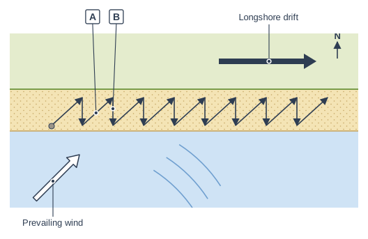
Figure 1 shows a process that students investigated in a coastal fieldwork enquiry.
Name the movements of water labelled A and B.
Model answer
A is the swash and B is the backwash.
Explanation
The swash carries sediment up the beach at an angle, in the direction of the prevailing wind, and the backwash carries it straight back down at right angles to the coast under gravity. Repeated many times, this zig-zag movement is longshore drift, the process behind many coastal enquiries.
Mark scheme
1 mark
A: swash
the letters must be matched correctly
1 mark
B: backwash
Question 3
4 marks
Students planned to test the hypothesis 'Environmental quality improves with distance from the centre of a town'.
Explain the geographical theory or concept behind this hypothesis.
Model answer
The hypothesis is based on urban land-use models, which show a town as zones around the CBD. The CBD is crowded with shops and offices, with heavy traffic, noise, litter and very little green space. Around it the inner city has old, high-density terraced housing and former industry, so there are few gardens or parks. Further out, the suburbs have newer, lower-density housing with gardens, parks and quieter roads. Bid-rent theory explains this pattern: land is most expensive in the centre, so it is built up densely, while cheaper land further out allows larger plots and more green space. So indicators of environmental quality, such as noise, litter, traffic and green space, are expected to improve with distance from the centre - although regeneration schemes can create exceptions.
Explanation
Every hypothesis should rest on geographical theory; here it is the model of urban zones and the bid-rent idea behind it. Level 2 answers explain why each zone has different environmental quality, rather than simply asserting that 'the edge of town is nicer'.
Mark scheme
4 marks
Levels of response (4 marks). Level 2 (3-4 marks): Clear explanation of a relevant theory or concept (e.g. an urban land-use model of zones around the CBD, or bid-rent theory), with developed links showing why environmental quality would be expected to improve from the centre outwards. Accurate use of terms such as CBD, inner city and suburbs. Level 1 (1-2 marks): Basic, simple statements (e.g. 'the suburbs are nicer'), little explanation of the theory. 0 marks: nothing worthy of credit.
Indicative content (not a checklist; credit other valid points): concentric land-use models (Burgess-style) show zones around the CBD - CBD, inner city, suburbs, rural-urban fringe; the CBD is crowded, with heavy traffic, noise, air pollution, litter and little green space; the inner city has old, high-density terraced housing, former industry and little green space; the suburbs have newer, lower-density housing with gardens, parks and less traffic; the rural-urban fringe is greener and quieter; bid-rent theory: land is most expensive in the centre, so it is built up densely and green space is rare; land is cheaper further out, so plots are bigger; environmental quality indicators such as litter, noise, traffic, green space and building condition are expected to improve outwards; credit awareness of exceptions, e.g. regenerated inner-city areas or run-down outer estates.
Question 4
6 marks
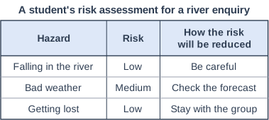
Figure 1 shows a student's risk assessment for a fieldwork enquiry measuring the width, depth and velocity of a small river.
Evaluate the student's risk assessment.
Model answer
The risk assessment has some strengths. It identifies real hazards - falling in the river, bad weather and getting lost - and checking the forecast and staying with the group are sensible precautions.
However, it has serious weaknesses. Falling in the river is rated as a low risk, but in a river with slippery rocks and uneven beds it is quite likely, so it should be rated medium or high. The control measure 'be careful' is far too vague: it should say exactly what students will do, such as only entering water below knee depth, wearing wellingtons with a good grip and working in pairs. 'Check the forecast' does not say what will happen if heavy rain is forecast - the visit should be postponed because the river would be deeper and faster. Important hazards are missing altogether, including slippery or steep banks, water-borne diseases such as Weil's disease (cuts should be covered and hands washed before eating), cold water, broken glass on the bed and traffic where roads cross the river. There is also no emergency plan, such as a first aid kit, a mobile phone and a named teacher to contact.
Overall, the risk assessment is inadequate. It is a starting point, but it misses several major hazards and gives vague measures that would not keep the students safe.
Explanation
A good risk assessment lists all likely hazards, rates each realistically and gives specific, practical control measures. Level 3 answers spot the missing hazards and vague measures, suggest improvements and make a judgement on whether it would keep students safe.
Mark scheme
6 marks
Levels of response (6 marks). Level 3 (5-6 marks): Detailed evaluation of the strengths and weaknesses of the risk assessment, identifying missing hazards, unrealistic risk ratings and vague control measures, with specific improvements. Reaches a clear, substantiated judgement on how adequate it is. Level 2 (3-4 marks): Clear evaluation of some weaknesses (or strengths) with some suggested improvements; may be unbalanced or the judgement simply stated. Level 1 (1-2 marks): Basic statements about the risk assessment, little evaluation, no judgement. 0 marks: nothing worthy of credit.
Indicative content (not a checklist; credit other valid points): strengths - identifies some real hazards (falling in, bad weather, getting lost); checking the forecast is sensible; staying with the group is a reasonable measure; weaknesses - falling in is rated low but is likely in a river with slippery rocks (should be medium or high); 'be careful' is too vague - specific measures are needed (depth limit such as below knee depth, wellingtons with good grip, working in pairs, no entry after heavy rain); 'check the forecast' does not say what will happen if the weather is bad (postpone, waterproof clothing); missing hazards - slippery rocks and steep banks, fast or deep water after rain, water-borne disease such as Weil's disease (cover cuts, wash hands, no eating near the water), cold water and hypothermia, broken glass or sharp objects, traffic on roads and bridges, medical conditions and allergies; no emergency plan (first aid kit, phone, teacher contact, meeting point); judgement, e.g. inadequate: too short and vague to keep students safe, although it is a starting point.
Ready to try the rest? Every answer you write is marked against the mark scheme, so you can see exactly where the marks are.
Ctrl + Enter to check
AI TutorHints first, answers after you try
Hi! Stuck? Ask me for a hint and I’ll help you work it out. Once you’ve checked your answer I can explain exactly where the marks are.