Level:
Correct: 0
Incorrect: 0
Marks: 0/0
Exam Practice
Subject:
Topics:
AQA GCSE Geography (Paper 2) Smart practice A mixed round aimed at your weak spots
Avg
score:
–
Topics
done:
0/23

Urban change in the UK: challenges and regeneration

Practise 36 exam-style questions on Urban change in the UK: challenges and regeneration for AQA GCSE Geography (Paper 2). Write your answer as you would in the exam and get it marked in seconds against the mark scheme, point by point, with an AI tutor on hand if you get stuck.

  • 36 questions
  • 1–12 marks each
  • Instant marking
  • No sign-up needed
20 questions, marked as you go

Sample questions with model answers

Here are 4 of the questions in this topic, each with a model answer, an explanation of why it earns the marks and the mark scheme an examiner would use.

Question 1

1 mark

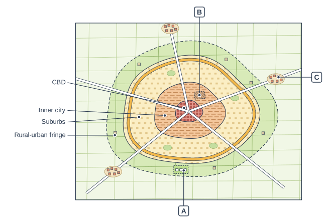
Figure 1 shows a model of land use in a UK city. Three places are labelled A, B and C.

Which letter shows a greenfield site?

Land-use zones in a UK city (plan view). A plan (map) of a city drawn as rings, one inside another. At the centre, where the main roads meet, is a small dark red zone of densely packed blocks. Round it is an orange ring with tight rows of small buildings, then a wide pale yellow ring with scattered houses and small parks, then a pale green ring of fields with a few scattered buildings, whose outer edge is a dashed line. Beyond that are open fields with three small villages on the roads. Five roads run out from the centre in all directions. Also: a thick orange road loops right round the city near the outer edge of the pale yellow ring; a small brown hatched plot with a dashed outline is in the orange ring, above and to the right of the centre; a bright green field with a dashed outline and three small white house outlines is in the pale green ring below the centre. The label "CBD" points to the small dark red zone at the centre, where the roads meet; the label "Inner city" points to the orange ring with rows of small buildings around the centre; the label "Suburbs" points to the wide pale yellow ring with scattered houses and small parks; the label "Rural-urban fringe" points to the pale green ring of fields with a few buildings, at the edge of the built-up area (inside the dashed line); label A points to the bright green field with a dashed outline and three white house outlines, in the pale green ring below the centre; label B points to the small brown hatched plot with a dashed outline in the orange ring, above and to the right of the centre; label C points to the small village on a main road in the countryside beyond the outer ring, on the right.

Model answer

A

Explanation

A is a field in the rural-urban fringe, land that has not been built on before, where new houses are being built - a greenfield site. B is a brownfield site in the inner city (land used before, for example by old industry) and C is a commuter village beyond the edge of the city.

Mark scheme
  1. 1 mark

    A

    do not accept more than one letter

Question 2

2 marks

Suggest two reasons why many urban regeneration projects are located on brownfield land close to city centres.

Model answer

When docks and factories closed, large areas of derelict land became available close to city centres. These sites already have roads, railways and utilities nearby and are close to jobs and services in the centre, so they are good places for new homes and offices.

Explanation

Inner-city brownfield land is where the decline happened, so it is where regeneration is most needed - and its central, often waterside location gives it potential. Examples include Salford Quays on the old Manchester Docks and Temple Quarter on railway land beside Bristol Temple Meads.

Mark scheme
  1. 1 mark

    Large areas of derelict land became available when industry, docks or railway yards closed

    max 2; 1 mark per different reason

  2. 1 mark

    Re-using brownfield land reduces urban sprawl and protects greenfield land

  3. 1 mark

    Infrastructure such as roads, railways and utilities is already in place

  4. 1 mark

    The sites are close to jobs, shops and services in the city centre

  5. 1 mark

    Waterfront sites (old docks, rivers, canals) are attractive for homes, offices and leisure

  6. 1 mark

    Government funding and enterprise zones target these run-down areas / regeneration improves the image of a city's gateway areas

Question 3

4 marks

Explain how dereliction can lead to further decline in an inner-city area.

Model answer

Derelict buildings and land make an area look run-down and give it a poor image. Empty buildings often attract vandalism, graffiti, fly-tipping and crime, so people feel unsafe. Because of this, businesses and developers are unwilling to invest in the area, so no new jobs are created. People who can afford to leave move away, so local shops lose customers and close, and even more buildings become empty. This creates a cycle of decline that is very hard to break without regeneration.

Explanation

The marks are for linking dereliction to its knock-on effects: poor image, crime, lack of investment, people leaving, shops closing - and back to more dereliction. A chain or cycle of reasoning reaches Level 2; a list of problems does not.

Mark scheme
  1. 4 marks

    Levels of response (4 marks).
    Level 2 (3-4 marks): clear explanation with linked, developed points showing how derelict land and buildings lead to further social, economic and/or environmental decline (a cycle of decline).
    Level 1 (1-2 marks): basic explanation with simple, unlinked points; may describe dereliction rather than explain its effects.
    0 marks: nothing worthy of credit.

    Indicative content (not a checklist; credit other valid points): derelict buildings and land look unattractive and give the area a poor image; they attract vandalism, graffiti, fly-tipping and crime, making people feel unsafe; firms and developers are unwilling to invest, so no new jobs are created; people who can afford to move away leave, so the population falls; local shops and services lose customers and close; the council receives less money from business rates and council tax, so services decline; contaminated land is expensive to clean, so it stays empty; the result is a downward spiral or negative multiplier (cycle of decline).

Question 4

6 marks

Using an example of an urban regeneration project, explain why the area needed regeneration.

Model answer

The Lower Lea Valley in Stratford, east London, where the Olympic Park was built, badly needed regeneration before the 2012 Olympic Games.

Environmentally, the area was one of the most run-down in London. The decline of industry had left large areas of derelict land, old factories, chemical works and scrapyards, and much of the ground was contaminated by industrial waste. The rivers and canals were polluted, rows of electricity pylons crossed the site and waste had been dumped on empty land. This gave the area a very poor image, so private developers were unwilling to invest.

Economically, the closure of industries meant there were few jobs. Newham, the borough where most of the park is, was one of the most deprived in England, with high unemployment and low incomes. Without investment, the area was stuck in a cycle of decline.

Socially, many residents lived in overcrowded and poor-quality housing, health was worse than the London average and educational attainment was low. There was little usable green space or sports facilities for local people.

The Olympic Games provided the opportunity and the government funding to clean up the land, improve transport and build homes, jobs and facilities, which is why the Lower Lea Valley was chosen.

Explanation

Explain the reasons under social, economic and environmental headings and link them - for example, industrial decline caused dereliction, which deterred investment and left high unemployment. Level 3 needs real place names and accurate details of your chosen project.

Mark scheme
  1. 6 marks

    Levels of response (6 marks).
    Level 3 (5-6 marks): detailed explanation of the social, economic and environmental reasons why the area needed regeneration, with well-developed points (e.g. linking the decline of industry to dereliction and deprivation); detailed place-specific knowledge of a named project.
    Level 2 (3-4 marks): clear explanation with some developed points; some place-specific detail.
    Level 1 (1-2 marks): basic explanation with simple statements; generic, not place-specific.
    0 marks: nothing worthy of credit.

    Indicative content (not a checklist; credit other valid points): Olympic Park (Lower Lea Valley, Stratford, Newham): the decline of industry left large areas of derelict and contaminated land (old factories, chemical works, scrapyards, waste tips); polluted rivers and canals; overhead power lines on rows of pylons and dumped waste gave the area a very poor image; Newham was one of the most deprived boroughs in England, with high unemployment, low incomes, poor health, low educational attainment and overcrowded, poor-quality housing; little usable green space; little private investment; the 2012 Olympic Games provided the opportunity and funding. Salford Quays: the Manchester Docks closed in 1982 because ships became too large for the Manchester Ship Canal and trade moved to container ports; thousands of jobs were lost; derelict docks, warehouses and polluted water; deprivation in neighbouring areas such as Ordsall. Temple Quarter, Bristol: derelict and under-used railway land, empty warehouses and industrial buildings around Temple Meads; poor road layout and access; a poor first impression of the city; deprived communities nearby (e.g. Lawrence Hill); credit any appropriate named project.

Ready to try the rest? Every answer you write is marked against the mark scheme, so you can see exactly where the marks are.

AI Tutor Hints first, answers after you try

Hi! Stuck? Ask me for a hint and I’ll help you work it out. Once you’ve checked your answer I can explain exactly where the marks are.